
Monday, December 26, 12022 HE
Yuletide Musings
Merry Christmas! And to the non-practicing christ-ians amongst us, I still hope your appropriated holy day holiday was merry and cheerful.
Perhaps a better acclamatory would have been Happy Boxing Day since this post is happening on the second day of Christmastide. I only recently learned the origin of Boxing Day as the second day of Christmastide. Historically, Boxing Day was a chance for the less well-to-do amongst us, the poor, servants, and sometimes slaves, to receive gifts from the well-to-do. Very much on par with the older traditions of Saturnalia which was the Roman winter welcoming festival in celebration of the god Saturn.
Historic festivals welcoming the Hibernal (December) Solstice like Saturnalia and the Germanic pagan tradition of Yule are the origins of our more modern rendition of the Christian celebration of Christ’s Mass (in Old English Crīstes mæsse). The once appropriated Christian celebration of the birth of Jesus, Crīstes mæsse, is now ironically appropriated for many as a more secular celebration, our modern Santa Claus-themed Christmas. Historic accounts of Jesus’ (or Christ’s) birth tend to trace it to the Vernal (March) Equinox. The pseudo-scholarly quip to the December 25th date is why would shepherds be herding in the middle of the winter? There is no birthdate provided in the bible. So one account is that needing a date for their founder, fourth-century Christians (i.e., Pope Julius I) coopted Christmas to coincide with the current pagan traditions of the time. The Romans celebrated Saturnalia, which spanned December 17th to 23rd, encompassing the northern hemisphere’s winter solstice as well as Sol Invictus (the rebirth of the Unconquered Sun) on December 25th. There is speculation that the Roman rulers of the time decided to choose December 25th as Christmas for political means, as an act to weaken the pagan celebrations. Constantine had recently declared Christianity the religion of Rome and as such was motivated to bolster its prominence.
Cosmologically relevant to this conversation is that Christmas currently closely coincides with the northern winter (hibernal) solstice around December 21st/22nd. Two weeks after the hibernal solstice, around January 2nd-4th, is perihelion when the Earth is closest to the Sun. This has nothing to do with New Year, which it turns out is just a random selection starting point and has even shifted in different cultures over time (e.g., the Romans used to start their calendar in March which is why September, October, November, and December’s calendar count is at odds with their Latin numeral prefixes of seven, eight, nine, ten. To find out why check out this video). Perihelion often coincides with exceptionally high tides as the Sun’s gravitational effect on the Earth’s tides is greatest. Around this time, the not officially defined King Tide can also occur. I did a post, “On Tides,” covering this in more detail.
Weather Conditions
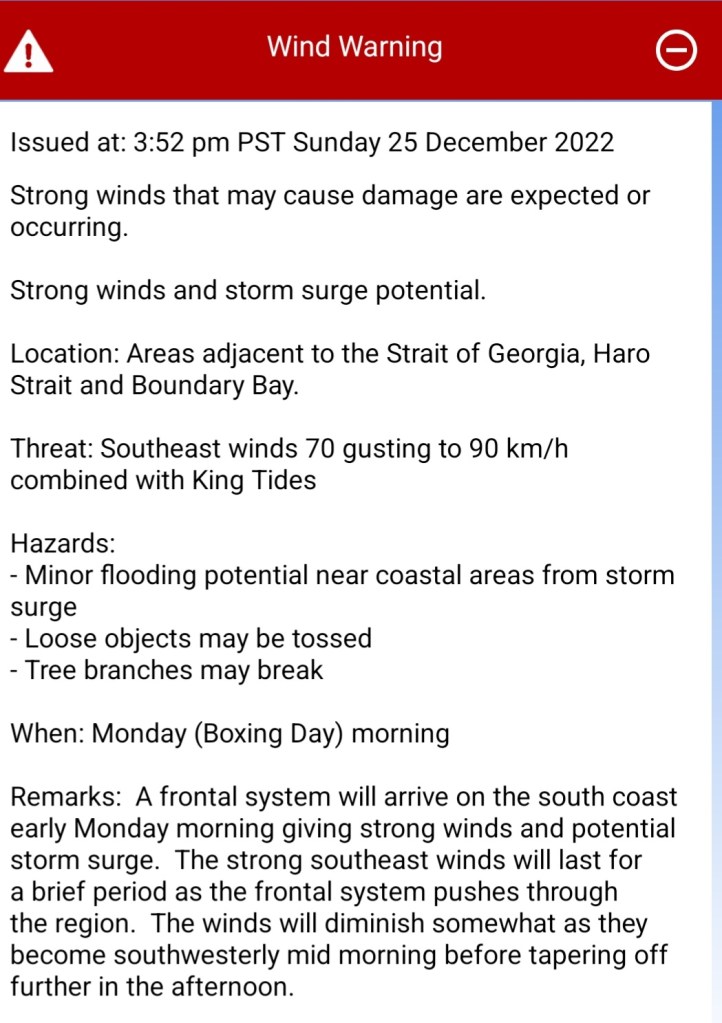
So, when my WeatherCAN app alerted me to “Southeast winds 70 gusting up to 90km/h combined with King Tides,” I was excited (see image below for details). I was already planning for a Boxing Day paddle. It is always enjoyable to get some physical activity after the gluttony of the Yuletide feast and festivities. The question was just where to paddle? We were staying in North Vancouver at my in-laws’ place so my close options were Səl̓ilw̓ət (Burrard Inlet), Səl̓ilw̓ət (Indian Arm), or Átl’ḵa7tsem (Howe Sound). I had been eyeing the easterly outflows forecasted in Səl̓ilw̓ət (Burrard Inlet) earlier in the week for a potential downwind run from Ambleside to Caulfeild Cove. But with the southeasterly winds forecasted to turn into southwesterly winds mid-morning, I wondered if I would be able to launch from Caulfeild Cove, round Point Atkinson, and downwind the Queen Charlotte Channel (click here for the boundaries), at the mouth of Átl’ḵa7tsem to Whyte Cove. The Səl̓ilw̓ət-Átl’ḵa7tsem run.
I checked the daylight. Sunrise was 0807 hours. I checked the tides. High tide at the Point Atkinson station was predicted to be five metres at 0845 hours. A departure around 0430 would set me up for the peak flood but with no light. The forecast factors were looking good, but I would have to settle on a 0800-ish departure for daylight. If I could round the point into the southeast/westerly, then I should have a tailwind and the tail end of the flooding King Tide to help me get to Whyte Cove. A weaker peak than at peak flood based on the rule of thirds, but a push in the right direction nonetheless. Paddleboarding a King Tide in the Queen’s Channel seemed SUPer serendipitous! Plus I couldn’t help but make the parallel to the recent regale events and given the approaching New Year, the inevitable monarchial mentions in the year-end in review. I’d be doing my own mini year in review with a queen passing and rising king (too soon😬…perhaps for the Brits). As such, I deemed the downwind was worth a shot provided things looked safe on a shoreline survey for a storm surge solo SUP.
Launch Site
On the drive down to Caulfeild Cove, the conditions looked good. I could see patches of blue sky on the distant horizon. It was the calm in between the storms since we were slated for another storm starting near sundown.
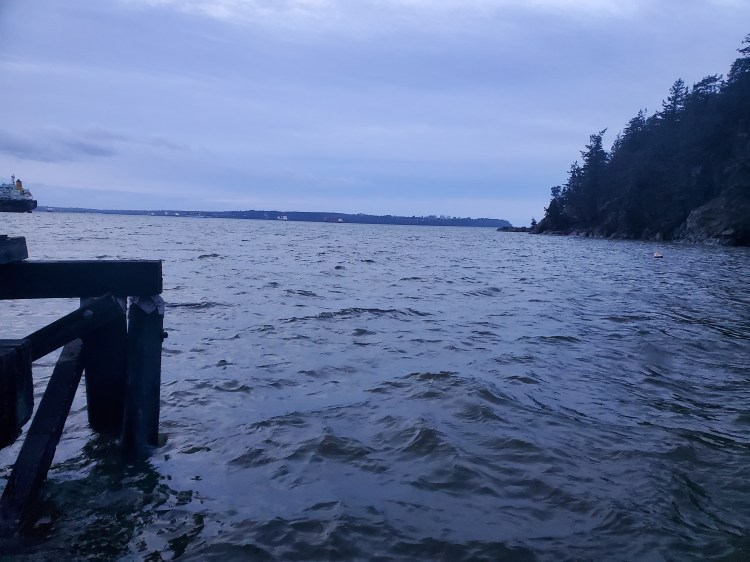
Once I arrived, I did a quick survey of the cove. The water levels were the highest I’ve ever seen them. The normally inclined ramp down to the dock was nearly horizontal. Below is the view from the ramp out into the bay with the bridge to the Point Atkinson Tide Gauge Station in the foreground. That bridge is fixed, but the normally sloped ramp that I was standing on was nearly straight.

To get a better view of the water before making my final call I went out to the small point next to the old pilot house. The video below is the view from there. The waters here looked calm enough to get around Eagle Point, at least for starters.
Below is the view from the dock just before launching. The water was textured.
Board Choice
Launching into the chop coming into the cove I immediately felt unsteady. I was on my hardboard and it had been a few weeks since I had been on a SUP. The last SUPing I had done was in Hawaii and it was on my bigger more stable inflatable board. Was it the chop? Me? My narrower board? Or all three?
I made my way out toward the moored ship heading straight into the main southeasterly swell. But further out southwesterly waves were joining the party plus perhaps some rebound off of the edge of Eagle Point. I put my paddle slaps and hip corrections to the test to stay on board.
My Kit
Within a few minutes of paddling, I knew that I was overdressed for the occasion. But, I was happy to be too warm than too cold as I figured there was a high chance of spying some nereids or mermaids later that would tempt me to take a plunge. I was in my semi-drysuit with Icebreaker merino wool 260 zone baselayers underneath. I also had a hood and gloves to protect my head and hands and was wearing my NRS Ninja PFD for insulation and floatation. Also for safety, I had my VHF Marine Radio and cell phone for communication.
As I passed Eagle Point and could view Starboat Cove to my starboard side the view westward was spectacular. The subdued blues from the morning twilight had brightened and there was a beautiful contrast between the stratus clouds overhead and the crisp blue winter sky on the horizon. But I wasn’t feeling steady enough to take a picture so you’ll have to take my word and imagine the scene.
I took a wide turn to get around Point Atkinson to manage the chop. I pulled my hood down to cool off. I was now fully exposed to the large southwesterly waves entering from the strait but still subject to the forces of the mixing waters between Queen Charlotte Channel and Səl̓ilw̓ət (Burrard Inlet) and the wind. Around the point, the wind changed to be purely a tailwind. This was my hope from my past experience when I SUP toured the Sound in the summer from Vancouver to Squamish. However, on my summer trip, the conditions were much cleaner with a few long runs despite being on a slower gear-laden board. So I was slightly disappointed that I was struggling to catch any runs of length on an unloaded performance board. The waters were a choppy mess of mixed-up waters and my fitness and footwork weren’t up to the feat.
I think it was somewhere around Juniper Point, but I ended up falling in so many times that I can’t quite recall. The rebounding waves from the shoreline along with a cross current in the chop knock me off balance. It was the cool-off that I needed and maybe I spied a mermaid too.
Back on board I collected myself and wondered how the wind would feel over my wet gloves. I was still warm. I got my bearings and aimed toward splitting the Grebe Islets. The waves were a bit cleaner through this section as they funneled in between the rocks. It wasn’t long before I was back in the water, though. The crossing outflow current from the embayment at Gulf Beach Park created by the southern waves was too much. Another dip of many more to come. It seemed that all the small bays along the coastline had strong cross currents exiting their southern shores that would shear me off my board. I found the diagram below which explains the phenomenon I was experiencing post-paddle. A series of mini-gyres cycling water through the various coves and bays.

Source: https://ozcoasts.org.au/conceptual-diagrams/science-models/geomorphic/emb/emb_hydro/
On the other side of the Grebe Islets, I could see the Nanaimo ferries come into view. I contemplated a Hạ Long Bay-style kissing chicken rock photo but the sea state wasn’t in my favour. Instead, I concentrated on keeping my balance. Though apparently, I wasn’t concentrating hard enough, as I found myself jumping off my board once again to clear its rails as I lost my balance. I quickly clambered back on board as I didn’t want the distant ferry ogling eyes or overly concerned citizens to worry about my wobbliness. However, it didn’t matter as moments later I found myself floundering for fresh mermaids in full view of the ferries.
The gyring bay currents became more challenging the closer I got to Whyte Cove. Fatigue, or lack of fitness, was becoming more of a factor in my mermaid forays. I was glad that we had settled on Whyte Cove for our pick-up location versus Horseshoe Bay as the cove came into sight.
The Landing
Along the shore, I saw a beach-goer out for a walk. I was pleased that someone else was out enjoying the morning. Then it dawned on me that it was likely my father-in-law. Moments later the gentleman on the distant shore was waving at me confirming my hypothesis. I waved back and then continued to paddle. He waved again. That’s odd, I thought, maybe he didn’t see me wave back? I waved back again. Next, he started to two-hand wave overhead. That’s odd‽ Can he not see me? I waved my paddle back in the air to confirm that I had seen him. His wave then shifted to a much more animated horizontal motion. He was waving me off‽ Then I realized why. The shoreline, or lack thereof, was submerged by the King Tide. The water was right up to the flat walking path at the top of the ramp that leads down to the beach. On top of that, the storm surge had lined the shore with driftwood logs and massive stumps. The high tide rocky shoreline landing I had envisioned was an impossibility. As a sinking sense of reality set in, I felt stupid that I hadn’t considered what a King Tide storm surge landing might look like. I snapped back into the present. What do I do now?
At this point, my father-in-law was sending aggressive shoreline traffic control signals to get my attention. I interpreted the first as what would have been the dance moves of Chic‘s “Le Freak” song if the original lyrics of “fuck off” had been used instead of “freak out.” The message was clear, you’re not landing here, freak out, and go to Horseshoe Bay. The problem was, my tired legs were singing freak out right back. Just not with such animation. The track changed or he felt my legs freak out response, and he then waved towards Batchelor Bay as an alternative. Batchelor Bay was close but unfamiliar to me as a landing site. He was too far away to hear me, and I wasn’t about to get on my phone to call him, so I decided to paddle into shore. That way I could survey the shoreline and then if there weren’t any options to land we could converse to come up with a plan.
I was worried as I approached. This would be my most challenging hardboard landing. The advantage of an inflatable board is I wouldn’t hesitate to smash up against the rocks to land. I was definitely hesitant about that approach on my hardboard. I decided to go to my knees. The local landing options were near the logs and clambering over or a rocky landing with a small surge pushing me into shore. In my imagined landing, the cove had more protection from the southerly waves. In reality, the waves were still entering the bay from the mouth as well as over the top of the tombolo that connects Whyte Islet to the mainland at low tide.
Thankfully, where my father-in-law was standing, at the northwest corner of the beach, appeared to be the best landing spot. There was one log floating next to a rocky outcrop. If I could get close enough, I could step over the log onto the rocks. I positioned my SUP parallel to the log so that it would protect my board from the rocky shore. Then with a few draw and push-away strokes, I was able to nudge my SUP and the log closer to shore so that I could step over the log to the rocks. Then it was just an awkward lift of my board over the log. Thankfully, it is quite light. And there I was safely onshore, downwind run complete!
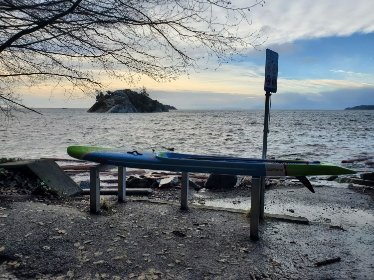
The image below is a gratuitous board pic looking out over Whyte Cove after making a safe landing. Whyte Islet is on the left, with the tip of Passage Island peering out on the right. The tip of Nex̱wlélex̱m (Bowen Island) is on the right.
Then conifer carnage along the shoreline can be seen below. A sea of logs blocking my would-be path to the shore.

The video below pans the view along the log-locked shoreline to where I landed at the far side of the cove.
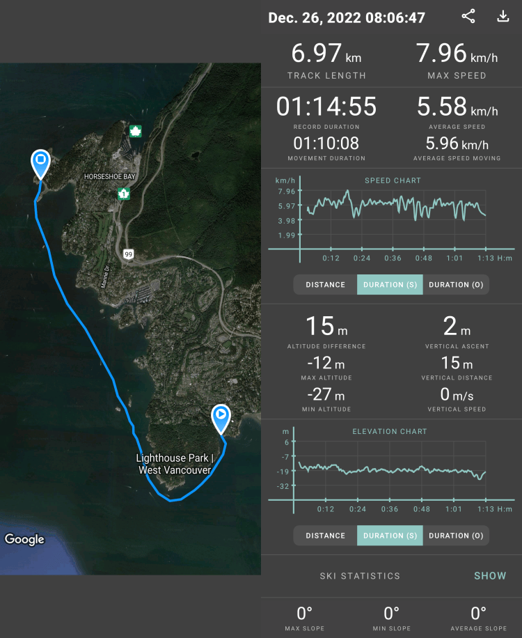
Lastly, here is the route that I took recorded with the Geo Tracker app.
The King Tide storm surge in the Queen Charlotte Channel proved to be a formidable challenge with a great lesson on high-water level landings. The beach might not be where/what it normally is with rex-level tides!
