Sunday, December 6, 2020
I grew up in Squamish, so paddling through the Squamish River Estuary has been on my paddle radar for some time now. I remember canoeing through the estuary with my best childhood friend, Jeff Kindree, and his aunt and uncle. So on Monday, when Annie asked me if I would be paddling in Squamish anytime soon so that I could drop off some books for her girlfriend, I said I could go on the coming weekend.
And then, on Tuesday, the topic of this blog came up with a client, David Riley. He suggested that from his experience, a 360-degree camera is a great way to give someone else a very real experience of being present. He graciously offered to lend me his Insta360 One X camera for a trial. There was a part of me that was reluctant initially. For the reason that I do not want to feel the pressure of needing to take the right photo/video for this blog to detract from being present in the moment when paddling (I wrote about this dilemma here). But at the same time, one part of writing this blog is that it could, serve as inspiration for someone else to go out and paddle (and another reason is to serve as a resource for other avid local paddlers for route ideas/details). I found other blogs and posts online to be valuable resources for helping to highlight details as well as serve as inspirations for paddles (e.g., the Urban Oarsman‘s site). And my brother Mwalu’s feedback after reading a post was “more pictures.” So given an opportunity to try out some cool new tech, how could I refuse.
Paddle Plan
DATE: Sunday, Dec. 6, 2020
ROUTE: Newport Beach, Squamish to Squamish River Estuary (round trip)
EST. DEP.: 0745
EST. ARR.: 1015
Details:
Sunrise
- 0753
Tides (Squamish)
- 0249 Low 1.1 m
- 1043 High 4.7 m
- 1701 Low 3.3 m
Wind
- Forecast: see windy.com app
- Northeasterly 2 kt (10-11 kt wind gusts)
Paddle Distance ~8 km
Paddle Time ~2-2.5 hrs
Drive time:
- Vancouver to Newport Beach: ~60 min
- Newport Beach to Vancouver: ~80 min
Personal Info
- TRAVELLERS: 1 (Mon Jef Peeters)
- VEHICLE: [Colour] [Year] [Make] [Model] [License Plate]
- PHONE: [xxx-xxx-xxxx]
Itemized Itinerary
- 0630 🚗 Departure
- 0730 🚗 Arrival at Newport Beach, Squamish
- 0745 🛶 Departure Newport Beach
- 0945 (1015) 🛶 Arrival Newport Beach
- 1005 (1035) 🚗 Departure Newport Beach
- 1125 (1155) 🚗 Arrival Home
David also had all the kit included with the camera: Venture Case (waterproof with 1/4″ action mount), selfie stick, extra batteries, soft case, etc. So after a quick crash course from him when I picked up the camera on Friday and some tinkering with the camera Saturday night, I was set to go for Sunday morning. The problem when I arrived at Newport Beach in Squamish was that my board and the Venture Case were both threaded holes and different sizes to boot. I had anticipated the double-threaded-hole scenario in my mind’s eye on the drive up. I figured could MacGyver the selfie stick into my PFD and then have an overhead aerial view.
After putting on my drysuit and PFD, I did a quick dry-land test to ensure my selfie stick setup worked. My drysuit was probably overkill. For such calm waters, I wasn’t likely to fall in. But as I have said before, I am a fairweather activity-ist. And, on a more serious note, you always want to dress for the water temperature, just in case. The setup worked. The stick fit in perfectly down along my spine between the PFD with the camera floating overhead. I mocked up a few paddle strokes to ensure the selfie stick would be comfortable as I moved my spine. I could feel it but was fine, so I grabbed my kit and headed down to the shoreline!
There is nothing scenic in the video below, but I just thought it was comical to see me try to set up the camera. I recently introduced my kids to Transformers: The Movie, the original cartoon from 1986, and we have been rocking out to the soundtrack. So I layered a few select tracks for the videos. I thought it was fitting to relive my childhood in multiple ways for this voyage. You can drag on the screen or tilt your device to change the orientation of your view. What is great about the Insta 360 One X camera software is there is built-in editing that makes the selfie stick invisible. If you aim the view down at the start of the video, you can see how it looks like I tuck nothing into my PFD, when in fact, it is the invisible selfie stick. Also, you can select a setting that recognises that the camera is in the Venture Case and will edit out the frame of the case. The result is quite amazing, but you can still see a slight blemish in the image where the seams of the case are.
If you are unable to scroll your view in the link above, you can view the video on YouTube.
The tide was high enough for an easy launch. Just after launching, I realized that I forgot to start up Google Fit to track my route. Too much attention was going to the 360-degree camera.
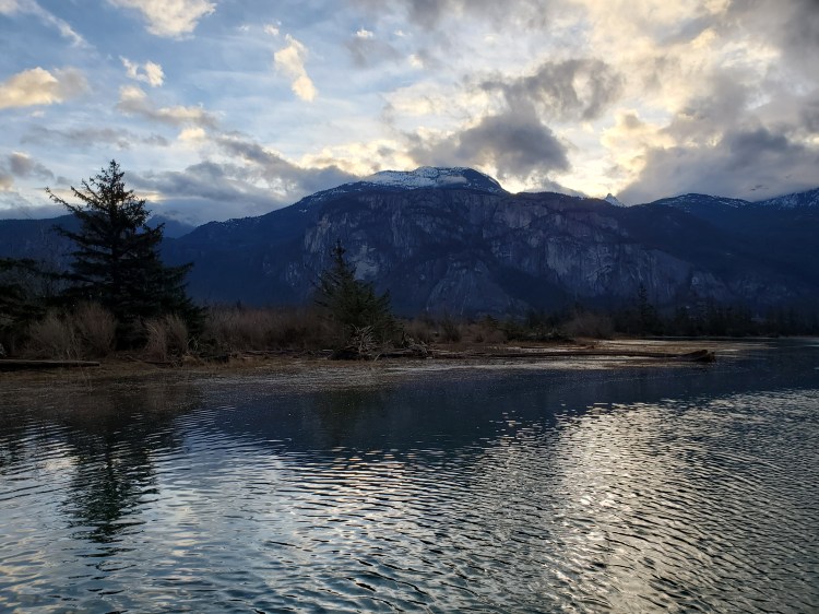
There is an incredible view of the Stawamus Chief from the Mamquam Blind Channel, and the weather looked like it would hold out for me as I made my way out south towards the end of the Newport Beach peninsula. Then I cut west across the north end of the sound toward the Squamish Terminals. The water was calm and glassy. I decided to stop recording from the Insta360 One X camera so that I would not have too much footage to sort through afterward. It was slightly awkward to access the camera from my setup but doable. There is an application that you can download to operate the camera from your phone. But, I was not able to successfully set it up in my brief home trial. At the end of the video, you can see that I can’t see if I successfully stop recording, so I then bring the camera around to turn it off.
If you are unable to scroll your view in the link above, you can view the video on YouTube.
I turn the camera back on as I cross in front of the Squamish Terminals before turning north into the Squamish River Estuary mouth. I was heading in with the rising tide but with a light headwind.
As I travelled further into the estuary, I was surprised that there was still a decent amount of current to go against, and the wind at times felt stronger (but it was nothing like Monday’s wind in Burrard Inlet). I stuck to the east bank and figured I would come back along the west side. I turned the camera off again to save editing time.
If you are unable to scroll your view in the link above, you can view the video on YouTube.
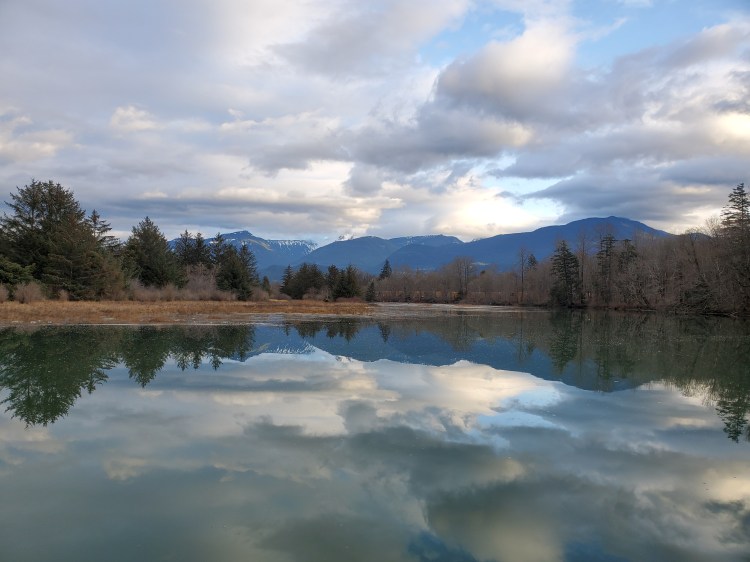
A bit further on, I turn the camera on again. I wanted to catch the beautiful morning light. It was breaking over the top of the mountains and through the clouds. I contemplate turning the camera back off but decide that I do not want to be fiddling back and forth with it. So I left it on. I did not bring the extra batteries with me on the water for fear of dropping them. I failed to realize how much power continuously recording was going to use.
A bit deeper into the estuary’s grasslands, the winds calmed, and I found a small channel that was heading back east towards the Chief. I decide to explore. I approached cautiously to ensure that the waters were deep enough. They were, so I ventured in.
If you are unable to scroll your view in the link above, you can view the video on YouTube.
There was a light current running into the channel. I followed the channel to a fork and decided to go straight. Eventually, it looked like I would be stopped by the train tracks ahead, so I stopped and turned around. I did not know it at the time, but this was where I had exhausted the battery for the Insta360 One X camera. I turned back and took the other arm of the fork. It forked again into two arms. But both were blocked by fallen trees. I turned to head back out of the channel.
Once out of the channel, I noticed that the green light to the Insta360 One X camera was no longer lit. I pulled the selfie stick out of my PFD set up and tried to turn it back on. It read “low Battery.” Realizing that my continuous filming had drained the battery, I decided to pack the camera up into my dry bag. At the time, I wondered when the camera had died. I would have to wait until I was home to examine the video.
From here, I continued further up the main channel. This led me toward the Skwelwil’em Squamish Estuary Wildlife Management Area. Further up, there was another interesting branch to my right that I considered exploring, but I decided against it. I wanted to get further up into the estuary, but I was unsure if my time would permit it.
I came to some dolphins (not the mammals but pilings). It was a stark reminder of the history behind the waters. Historically, it was an industrial work way, not a wildlife management area. The pilings had numbered letterboxes on them. I figured they had to be a coding system for moving log booms in the past.
On the bank to my right (east), I could see some dogwalkers traipsing through the trails along the eastern bank. Ahead of me, the channel continued north, bending westward out of sight. You can see the dyke to the railway tracks in the clearing between the coniferous foliage. My time was running out, so I decided it was time to turn around.
I stopped for a few more photographs on my way back out of the channel.

I spotted an eagle watching over the waters from its treetop perch. It is just below the white stripe of the waterfall in the centre of the image below.

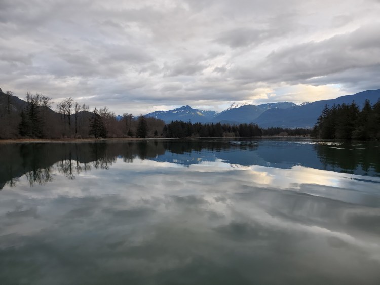
The clouds were starting to roll in thicker. The morning hint of sunshine had long passed. But the channel was still awe-inspiring.

I decided to cross to the western bank of the channel to get a different view of the Stawamus Chief. I have hiked the Chief countless times throughout my life and looked down on the Squamish River and surrounding area, so it was a fascinating experience to view it from the water.
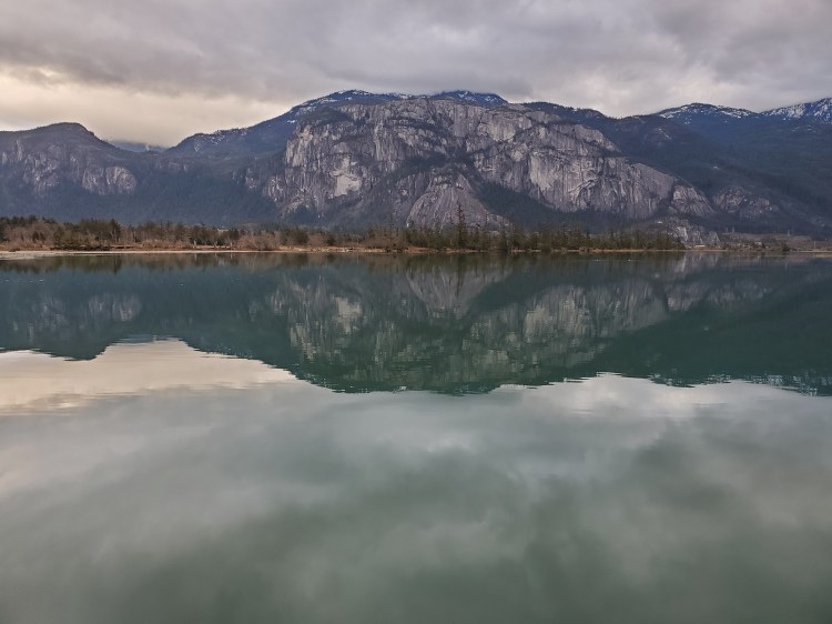
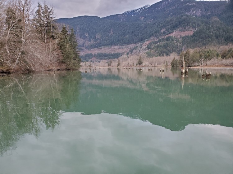
I continued along the western bank to just past the two small islands near the mouth of the estuary’s channel. Note that in the Google Maps satellite view, the islands are visible. But, they are absent in the map view. In real life, they are there, as you can see in the photo below. For this reason, you should always check out the satellite view or Google Earth to verify the terrain (or a map). I learned my lesson on this the hard way with my attempt to do the Serpentine Circuit, which looks like a circuit on a map view but is not in real life.

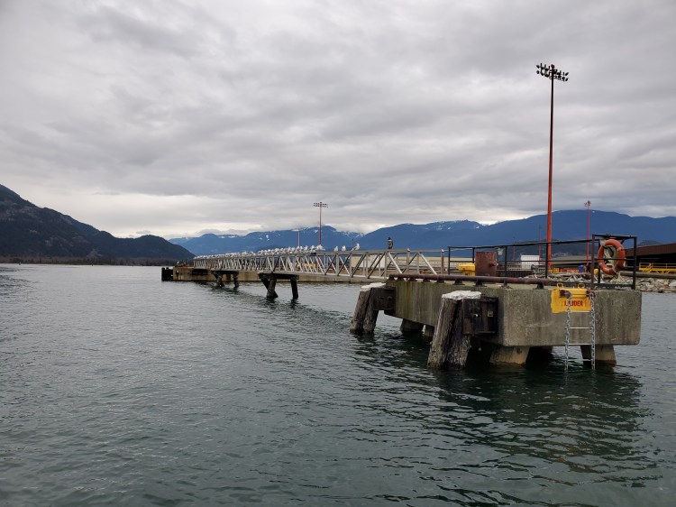
Exiting the channel, I paid more attention to the gulls resting on the terminal’s gangway. It seems that the owl at the end of the gangway is either not doing his job or has made friends with the seagulls.
Travelling eastward at the north end of the sound towards the Mamquam Blind Channel, you get a good view of Shannon Falls.

The watch owl at the southeast gangway of the Squamish Terminals deserves a raise or a promotion. No seagulls on its watch.

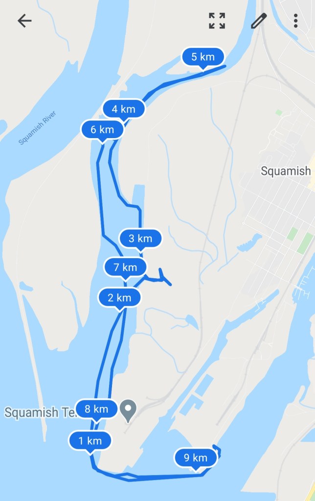
My Route