
Monday, October 25, 12021 HE
Weather bomb! Or as it is technically referred to, “explosive cyclogenesis.” I’m not totally sure how the phenomenon works. It seems to be defined by a rapid decline in barometric pressure over a specific time interval. In any case, it translated to a big storm offshore that was making for strong winds in the Vancouver area. I was intrigued by the forecast initially before I knew of the weather bomb. And only more so when I heard about the bomb and the possibility for record-breaking winds on CBC‘s weather report during the Early Edition.
In recent times I’ve come to grips with the reality that generally, I am a cautious person, as much as I would like to think that is not the case. So the idea of heading out on my board in record-breaking winds had me slightly concerned.
The image below is from Windy.com on Sunday and shows two offshore storms. All those brighter colours moving towards purple on the scale at the bottom had me excited and terrified.

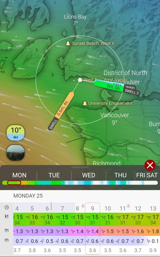
The image below is the forecast from Sunday for Monday. Fifteen knots of wind I felt I could handle, but it was the gusts up to 31 knots that had me intimidated.
I double-checked this Starboard web post that gives some guidelines for windspeeds to paddle in. The text below is a quote from the site.
The strength of the wind has a big impact on stand up paddling so as a ‘rule of thumb’:
SOUrce: https://sup.star-board.com/how-to-the-5-step-guide-to-planning-your-sup-paddle/
Less than 15 knots (less than 27km/h) is ideal flat water conditions
At 15 knots small waves and whitecaps start to form
At 20-25 knots (37-46km/h), more experienced paddlers may want to use the wind to surf downwind
Re-reading this gave me a bit of confidence that I am not completely crazy. Twenty to 25 knots? Check. I still wasn’t sure what to think about the gusts of wind ranging up to more than 30 knots and how that factored into the guideline?
The other intimidating factor was that I didn’t have a paddling partner. Monday is not the day for most people to have free time on their hands. The lack of a paddling partner was challenging both from a safety standpoint as well as logistically. The only way to really take advantage of these wind conditions was a one-way trip. That amount of wind over any longer distance would be impossible to paddle through. At least for me, it would.
Normally, I would default to doing a solo-SUP on my Span-Kit Run, riding westerly winds from Spanish Banks to Kitsilano Beach (X̱epx̱páy̓em) and then take an Evo Car Share back to my vehicle. But with easterly winds, and strong ones, the challenge becomes not being blown out to the Strait of Georgia in the Salish Sea. With winds from the east, I thought my safest option to take advantage of the winds would be to paddle from Ambleside in North Vancouver to Caulfeild Cove, near Point Atkinson. I lightheartedly joked that the point would serve as a safety net to prevent me from being blown out to sea. Instead, I would end up splattered across the rocks.
But, in all seriousness, the decision to embark on this trip was not taken lightly. I investigated the forecasts, which were intimidating, at the least. Below is a Special Weather Statement released by Environment Canada. I had been out in winds of a similar speed before, last fall. But those winds were westerly. And the threat of a mishap was that we would be blown in towards Vancouver, not away. And, I was with a partner. There is safety in numbers. I based my justification for this paddle solo on the fact that I would be close to shore if something went wrong. I wouldn’t go out in these conditions without that fact.

My first dilemma was figuring out how to shuttle myself if I was to do the paddle solo. I considered looking into public transit. But that seemed like it would be too difficult. I would likely be soaked at the end of my trip and didn’t feel comfortable travelling like that for me, let alone my fellow transiteers. Another option was to hire a car. I could Uber back from Caulfeild Cove to my vehicle. But, before exploring that option, I decided to reach out to my dad to see if he was free. My dad helps with drop-offs and pick-ups with my niece and nephew for school. And, as luck would have it, he was both available and willing to help me out on this adventure.
Problem one solved.
Initially, my dad was only going to pick me up at Caulfeild Cove. But then it turned out that my wife needed the car to run some errands. Thankfully, my dad was able to pick me up and drop me off. He would come over after dropping off my brother’s kids.
In the morning, I checked the forecasts and real-time weather/wind reports. Below is how the weather bomb now looked on Windy.com.

And the wind and wave forecast for the north side of Burrard Inlet (Səl̓ilw̓ət) near West Vancouver.

I also checked the Hollyburn Sailing Club webcam and current weather conditions. The conditions looked mild, and the wind was minimal, as per below. Though, I did take note of the high wind value of 26.1 knots. The current conditions would make for an easy launch. The sailing club is at the start of the wind fetch and shielded from an easterly wind. So the wind there was deceiving. My concern was how that wind would build over the fetch and what the wind would be like at Point Atkinson, near where my exit point would be.

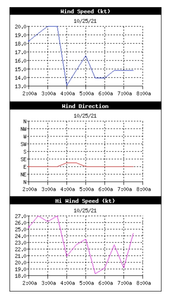
I decided to check the conditions at the Jericho Sailing Centre, on the south side of Burrard Inlet (Səl̓ilw̓ət). Here things were windier and more representative of the weather conditions I would likely encounter further into my planned paddle route. The 10-minute average wind speed was 18 knots, and the high was 29.6 knots.

The Jericho Sailing Centre’s current conditions page also provides graphs of the wind speed, direction, and high speed over the last six hours. Below are the trends from the early morning.
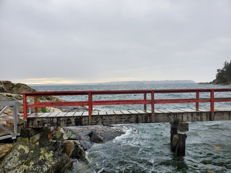
The traffic through downtown was pretty good, despite all the construction that I feel is happening around Vancouver. As such, we made it to West Vancouver with some time to spare. My dad and I decided to go check out Caulfeild Cove. That way, I could show him where to meet me after dropping me off at Ambleside, and I would be able to check out what the conditions were like at Point Atkinson. If the winds were too wild, I could always pull the plug on the paddle.
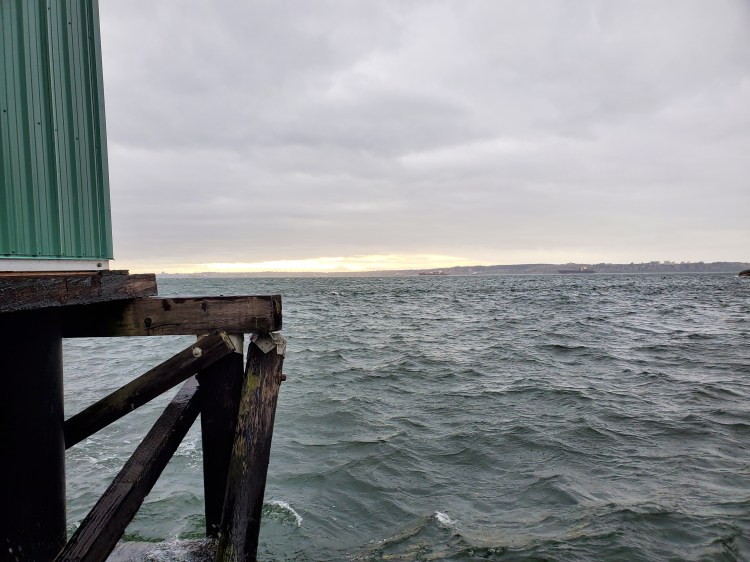
Here is the view from the public dock at Caulfeild Cove. The seas were not calm, but in my assessment, it was definitely paddleable.
And for a bit better feel of the conditions, here is a short video as I walk down the ramp to the dock to check out the situation.
We got back into my dad’s vehicle and made our way to Ambleside, near the Hollyburn Sailing Club. After getting my kit in order, I was ready to depart. I decided to go with my inflatable Onyx M-16 Belt pack PFD versus my traditional NRS Ninja PFD. I was going to be close to shore and was worried about overheating more than floatation. Obviously, the traditional non-inflatable PFD is safer, but I was confident in my board abilities and swimming if it came to it. And the shoreline was full of potential places to exit, something that one should always consider for safety on a downwinder.
I packed my cellphone with me in a Seal Line Seal Pak® Hip Pack. I would be able to call my dad for a pick-up in case things should go wrong. I also brought my Garmin inReach Mini satellite communicator. If I needed it for help, things would likely be too late, but it was worth having one other piece of backup telecommunication.
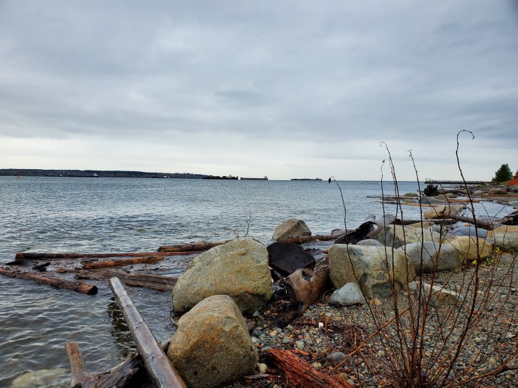
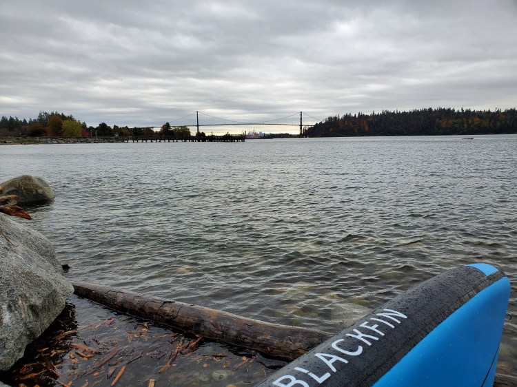
The conditions were very different along the shoreline at Ambleside. Aside from the overcast sky, you would hardly know that the weather bomb was going off. It is easy to see how an unwitting mariner could get caught up in bad weather over a relatively short distance. Caulfeild Cove was less than eight kilometres away.
Below was the view eastward back toward the Lion’s Gate Bridge.
And then I was off. I planned to get some video footage and had my camera mounted at the back of my board. Here is the launch.
I was hoping to shoot the video with a landscape view. But where I placed my camera turned out to be a problem unbeknownst to me. The conditions here were still very mild, and it just felt like a socked-in SUP.
It turns out the landscape orientation of my phone where the mount was, overhung the board too much. My paddle knocked the camera loose, and I ended up with an ample amount of blue video footage. It was the underside of my board. It turns out this was a harbinger of my video troubles.
Eventually, I realized that I had lost my camera overboard. Thankfully, I attached it to a lanyard for that reason. After a brief pause and reorientation of my camera to portrait view, I was ready to paddle again.
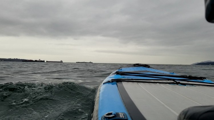
The wind was now starting to pick up. But it was battling against the current, with small waves starting to form. I set my sights on the tanker ships moored in the distance.
It was a little way after this that the paddling started to get good. At first, there were a few microcurrents that were leading out toward the strait. They created some faster-moving water. I strung together a series of small wind waves to pick up some speed and ride some runs.
Shortly before that, my camera must have gotten wet and tripped the touch screen to stop recording. So, I don’t have any footage.
Picture this, as I paddled onward the wind continued to get stronger. And along with that, so did the waves. I remember looking back to the shore and seeing the pink building in the Dundarave area when the conditions were getting good.
The waves got bigger and the runs longer as I passed West Bay
I stayed cognizant that while the wind may have been easterly, the waves were more southeasterly, ushering me out toward the Salish Sea. Riding the waves was fun, but I needed to watch Point Atkinson to not overshoot my exit point.
After riding a few runs directly out, I decided to change course to ensure that I’d make my exit point. I made a conscious effort to paddle across the bumps and get inside my line of sight toward Point Atkinson. I set my sight on the two moored tankers with the plan of going in between them to get to Caulfeild Cove.
It was when I was about in line with Sandy Cove that I had a petit panic attack. The wind had really picked up by this point. And when the gusts came, it was damn near terrifying. I struggled to paddle across the wind and chop. And as fatigue started to set in from paddling mainly on my port side, I began to question my decision.
The mind is a powerful thing. And mine was now beginning to wander toward the what-ifs I had considered beforehand, and the I told you so’s I was sure to hear if things went awry. Presuming, of course, that things only went slightly awry and I was rescued at sea. I looked back over my right shoulder to the succession of white caps chasing and overpassing me from behind. I looked back to front and left out toward the strait. I could see the headline, Solo Stand Up Paddleboarder Explodes in Weather Bomb.
I turned back to the gap in-between the two ships with a new resolve. Not me, baby! I’m not ending up on the news!
I buried my paddle blade into the water hard and drew it back. Then again, and again. Stroke after stroke, I pulled as my shoulders burned with effort. I was cutting across big bumps with some waves carrying me forward and others torquing me to my port side.
Then the waves settled. I was in the refuge on the leeward side of the first tanker. I straightened my legs momentarily and relaxed slightly on my paddling. But it wasn’t long before I was out of the wind shelter and back in the full force of the gusting winds.
And to my surprise and dismay, I was not quite in the clear of Point Atkinson. The wind was at its fiercest and trying its best to force me out past the point. And to boot, the rain had picked up. It was downright miserable with the rain angling down to the water. My mind raced again with doubts and fears, and a big wave caught me off guard, forcing me off my board into the water. I quickly clambered back onboard while noticing that my camera was off again. There would be no footage for posteriority. Oh, Vanity, you little b… The thought crossed my mind of trying to get my camera back up and recording. No! Get to shore, dumbass.
Back on my board, I renewed my frantic paddle across the chop aiming straight for Caulfeild Cove. Moments later, another large and chaotic wave knocked me off balance. I fell back into the water. Again I clambered back onto my board. I paddled on my knees for a moment, and it gave me some resolve to know that I could reduce my windage if needed. I had considered this earlier, but it was assuring to feel it in practice. It was the confidence that I needed. I hopped back up onto my feet.
There were a few more fleeting moments of fear, but as my blade met the water over and again and I drew closer to the shore, I realized that I was safe. The waves were still big, but I wasn’t going to blow out to sea. I relaxed as much as I could without being bucked from my board a third time.
I thought it would be nice to have footage of the finish, so I knelt and set my camera to record again. What is below is all the footage that I got. The wetness turned off my camera yet again. It was par for the course.
Riding the easing bumps into the cove, I dodged the wash-off debris of trees and sticks scattered about the shoreline waters. The dock was jostling about, which made for a less-than-graceful dismount.
As I walked my board up the ramp, I could see my dad parked and waiting.
I paused for a moment and went back down to the dock for one last picture and a short video from my cellphone. I made it.
I did check the historical weather data from Point Atkinson after my paddle. I was curious just how intense the winds were. It was in kilometres, with the peak speed around the time of my paddle being ~50 km/hr. Not as fast as I thought, but still respectable.
Below is the route that I took recorded with Strava.

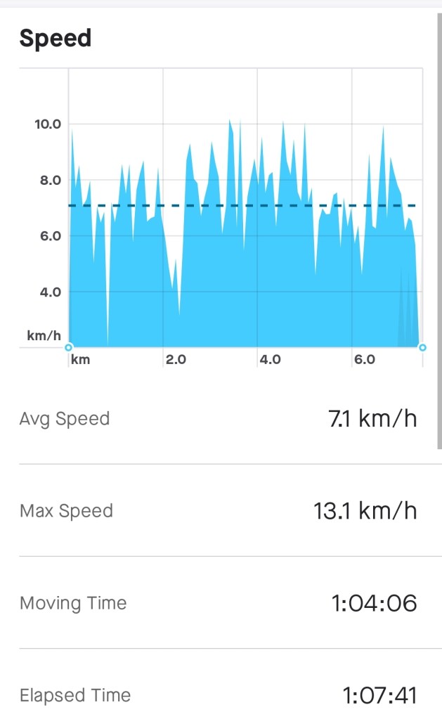
And a few more statistics of interest from Strava as well.
I have to give a big shout-out to my dad for helping to make this one happen! I hope one day that I will be around to lend a hand to my boys on one of their crazy adult adventures!
Merci beaucoup Papa!
