
The following is a list of different websites, applications, tools, and tutorials that I have found useful for my Stand Up Paddleboard (SUP) adventures. This page will be an ongoing project as I learn more.
- Trip Planning
- Weather Forecasts
- ‘Real-Time’ Weather on the Go
- Maps
- Ferry (Boat) Traffic
- Blogs
- Vlogs/Tutorials
- GPS Tracking
Trip Planning
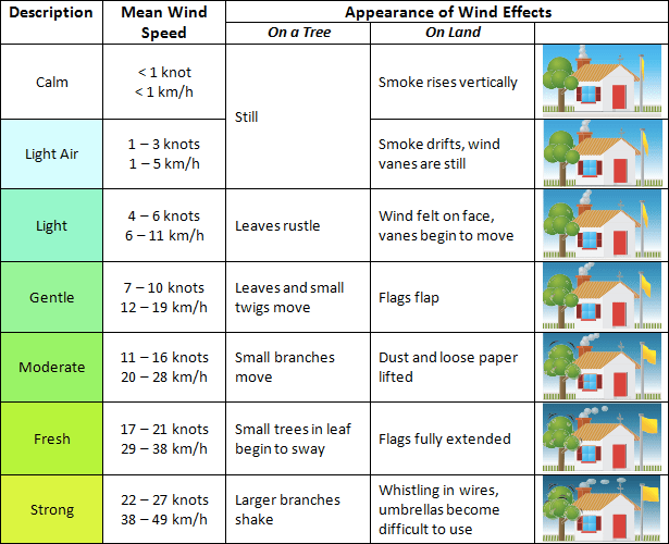
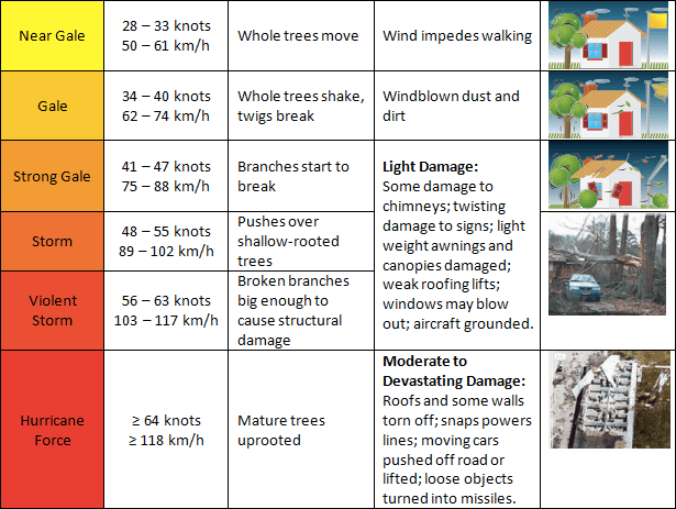
Starboard’s five-step guide. I used this web post as a heuristic for trip planning. It is an invaluable resource on things to consider when heading out on your SUP. The wind ‘rule of thumb‘ heuristic is a great way to determine what different wind speeds mean if you are new to wind-dependent watersports. I also came across this post, “How windy is too windy?” from The SUP Blog. The table below is a Beaufort Scale comparison chart from New Zealand‘s METservice blog site on “What is a fresh wind?” The beauty of the chart is it compares the actual Beaufort Wind Force Scale with quotidian windspeed events.
Another useful tool for local British Columbian paddlers venturing into the Átl’ka7tsem (Howe Sound) and/or the Salish Sea (Strait of Georgia) is this BC Ferries tracking site which shows where ferries are in real-time if you have access to mobile data or Wi-Fi. When on the water I use the app Marine Radar for real-time vessel vectors (I am an Android user, but I am sure there is an iPhone equivalent).
Float Plan. Always a good idea to leave one with someone when heading out on the water. Or at a bare minimum letting someone know where you are. Here is a template from the Canadian Safe Boating Council, or check out my post “Rules of Engagement” for my version of one and other safety tips.
Weather Forecasts
Environment Canada’s Marine Forecast. I often use this to check for specific weather warnings. I just Google the area that I am interested in. Though lately, I have been using Windy.com more to make my call on the weather. Just remember a forecast is a modelled prediction of what the weather will be. It does not always pan out and this can be for better or for worse.
Windy.com. I use the application on my phone but the website works well too. Initially I used to use it for rain generally and then wind specifically for SUP. Recently, I have discovered all the other weather capabilities available in the settings (e.g. swells, tidal currents, etc.). And best yet for my foray into downwinding is the weather alerts. You can set up an alert for specific weather parameters for specific days of the week and times of day.
Water Levels App. Lately, I have been using the Water Levels App from the Government of Canada’s Fisheries and Oceans site on Tides, currents, and water levels for tides. The downside is you need to separately look up sunrise and sunset times. I typically check these at timeanddate.com.
My Tide Times Pro. This is great for tides, sunrise and sunset, and currents (only for certain locations). It is a great app and was my go-to before changing to the Water Levels App.
‘Real-Time’ Weather on the Go
Experience has taught me that weather forecasts aren’t always accurate. They are models of reality. Imperfect attempts to represent and predict reality and is subject to whims of chaos theory (aka. butterfly effect). If you really want to know what is happening you need to put your boots on the ground. When that’s not possible or easy I have found that using webcams can be a useful supplement.
Webcams. This is a post that I did with links to local webcams giving you visuals for some local waterways.
Maps
Google Maps. Obviously. But I have discovered that it is very important to use the satellite view and not just the map view.
Google Earth. I started to use this as a way to sell trip ideas to paddling friends. And now it is my trip plan tool for sharing on this site. I use the “Projects” tool to do this.
i-boating. This is a free marine navigation chart and fishing map website and application. I tend to use the website and more often in retrospect to determine the names of different water bodies and marine locations.
Go Paddling. This application from paddling.com is a good one to find launch points near you. Or use it to find some ideas of where to paddle locally or when travelling.
BC Marine Trails. This website is a great resource for some of the coastal paddling routes with trail descriptions and other resources like events and articles. It also has a map tool that allows you to plan trips with things like launch sites, rest spots, and camping spots depicted. The site is freely accessible but it is recommended that you join for a nominal annual fee to help contribute to trail and site maintenance. I signed up and in my opinion, just the map alone is worth the membership.
Ferry (Boat) Traffic
Marine Radar. This app is great for tracking marine vessels. I use it to help with crossing ferry lines and have ambitions to use you to chase one of the local paddle wheelers to SUP surf their wake.
BC Ferries. BC Ferries has a ferry tracking site that lets you see the ferry’s position in real time for a select route. I prefer the marine radar app as I am able to see multiple vessels simultaneously, rather than just two vessels on a specific ferry route.
Blogs
Urban Oarsmen. This is a great blog for some local (Vancouver area) inspiration on where to paddle. This site introduced me to Still Creek and the Brunette River.
The Outdoor Family. This is a blog that covers outdoor family-friendly activities in the Lower Mainland Area. It has some great SUP-specific reviews of paddles to do.
Vlogs/Tutorials
Red Paddle Co. A great video resource for basic to more advanced skills. Check out the Nose 360 turn for a challenge!
StanduppaddlingTV. This is a SUP instructional video series by BIC Sport and it is a great introductory series covering basic water safety different paddle strokes to pivot turns.
Blue Planet. Great content in general and very detailed videos for all skill levels.
SUPboarder. Their “how-to” series are great and cover an array of topics (e.g. downwinding, touring, skills, etc.). It is one of the best sites for content that I have come across.
GPS Tracking
Because who doesn’t have a bit of ego and love seeing what they accomplished 😉.
Geo Tracker. This is what I use. I find it works well for me for SUP and it can track all types of activities too. Previously I was using Google Fit but I ran into technical difficulties with its recording accuracy.
Relive. This is a fun one to do what it says, relive your adventures. And for the little narcissist in all of us, a way to share your adventures with friends and family.
GEOSUP. This is a SUP-specific activity tracker. It is currently for Apple only so I have never used it. But the folks at SUPBoarder endorse it so I thought I would add it to the list. If they come out with an Android version I will give it a go.
