Sunday, September 13, 2020
This adventure was my second from the Surrey Blueways trio of waterways. The other two waterways that I have paddled are the Nicomekl River and The Fraser River Challenge. The Blueways Master Plan states that “The Serpentine Paddling Circuit provides a loop circuit for novice and exercise-oriented paddlers in the central Serpentine Valley”. I tried to find more information from first-hand accounts of people who had done the circuit but all the sites that I found simply reiterated the description from the City of Surrey site. I did find one post from a long time ago. It lamented about the odors, litter, and water levels for the paddling routes. But searching for the link again, I was not able to find it. However, given my previous experiences on the Nicomekl River, I was not too concerned. The smell I could deal with. The litter would probably be better since it was an old post, and the city is now actively promoting these waterways. And as for the water levels, that was left to be determined.
Here is a link to the Surrey Blueways Map PDF.
I scoured through the Blueways Master Plan document for a suitable launch site. There are proposals for future sites but nothing concrete for the present-day. The problem was finding a place that looked like it had a suitable place to enter/launch as well as adequate parking.
In the end, I decided I would try the bridge over the river at 168th Street in Surrey. The Coast/Meridian Greenway runs parallel to 168th Street here and I figured there would be a trail down to the river here. I reasoned that greenway cyclists are stop and check out river people. Plus, the Google Maps satellite view looked like there would be a place to park on either the north or south side of the river.
I was not able to secure a paddling partner. But since this adventure had been on my list for some time I did not want to let that stop me. The other foretelling warning was the Vancouver smog. But that was a risk I was willing to take since I did not anticipate the paddling to be very strenuous.
I had a meeting at 10:00 so I left early to be back in time. I knew I would arrive for my departure before daybreak so I packed my headlamp. The problem was that I did not anticipate the effect of the smog on my headlamp. The smoke reduced my visibility to several meters so exploring for a launch site was interesting. I parked on the north side of the bridge and initially checked out a trail heading down to the riverbank on the same side. I became a bit nervous walking down to the water’s edge with it still being the night, my poor visibility, and a few sounds of nature. I backtracked and tried my luck from the greenway bridge. No luck, the smog was too thick in the dark to see. I crossed to the other side and ventured out onto the dike. There was another trail down but no clear way to launch. I checked the east side off of the vehicle bridge but here there was fencing and thick brambles, no luck. I came back to the train bridge and with a little more light in the night sky I could make out the storm drains that I had seen on Google Maps satellite view. They were going to be my best bet.
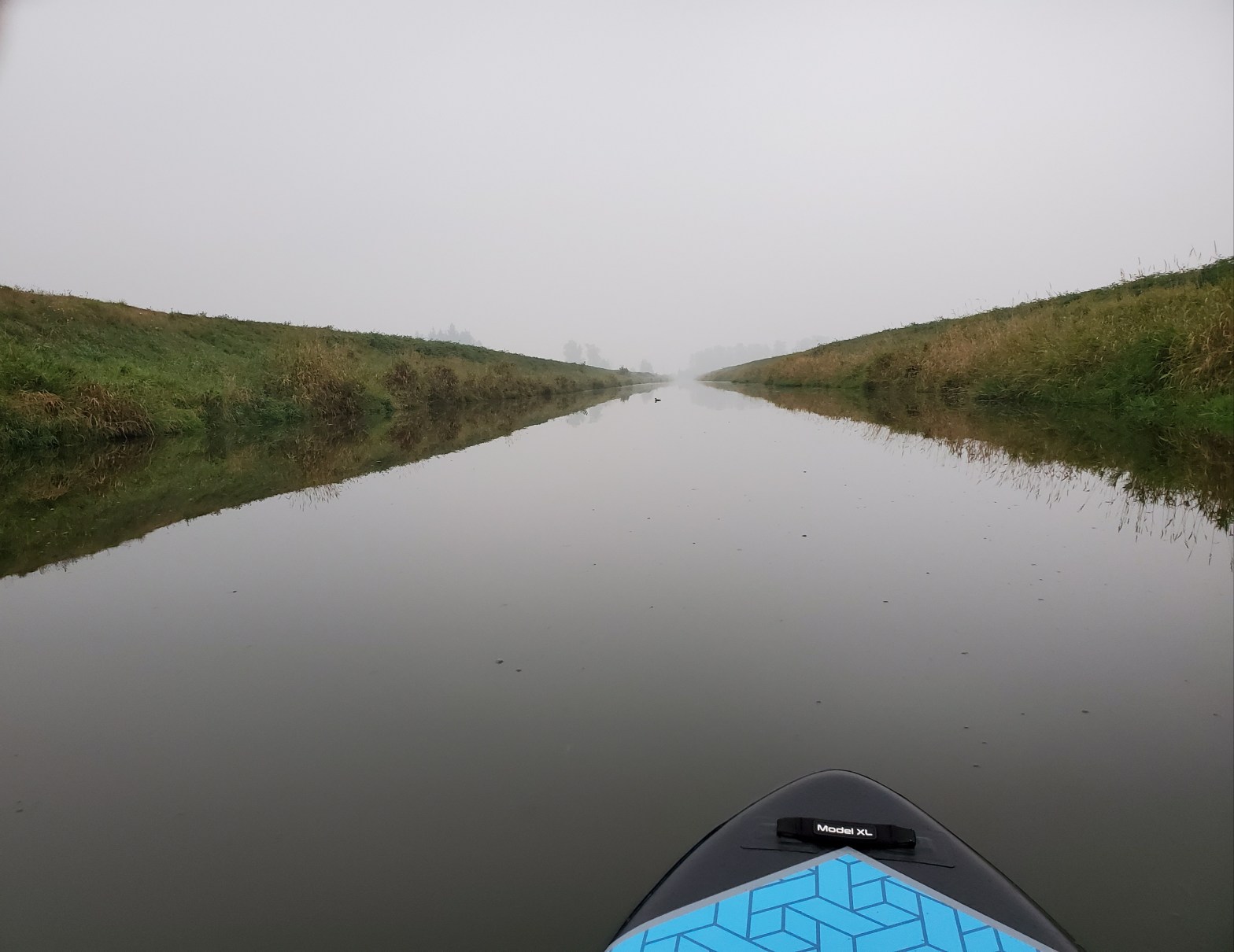
After pumping up my board and getting my kit in order the lighting was enough that I could see a clear path down to the water. The water was calm and the smog gave the waterway a mystic aura.


I have to be honest, paddling solo down the channel in the smog was a bit eery. It had the feeling I was in a post-apocalyptic film where I was left searching for signs of survivors.
When I reached the fork at the north end of Northview Golf and Country Club I decided to go left. The waters to the right looked shallow and less inviting. In hindsight had I tested out the right channel first I could have saved myself a lot of hassle.
It was a straight and easy paddle down the east arm of the circuit. There is not any scenery to speak of so save it for a clear your mind, serene, novelty of the exploration type of paddle.
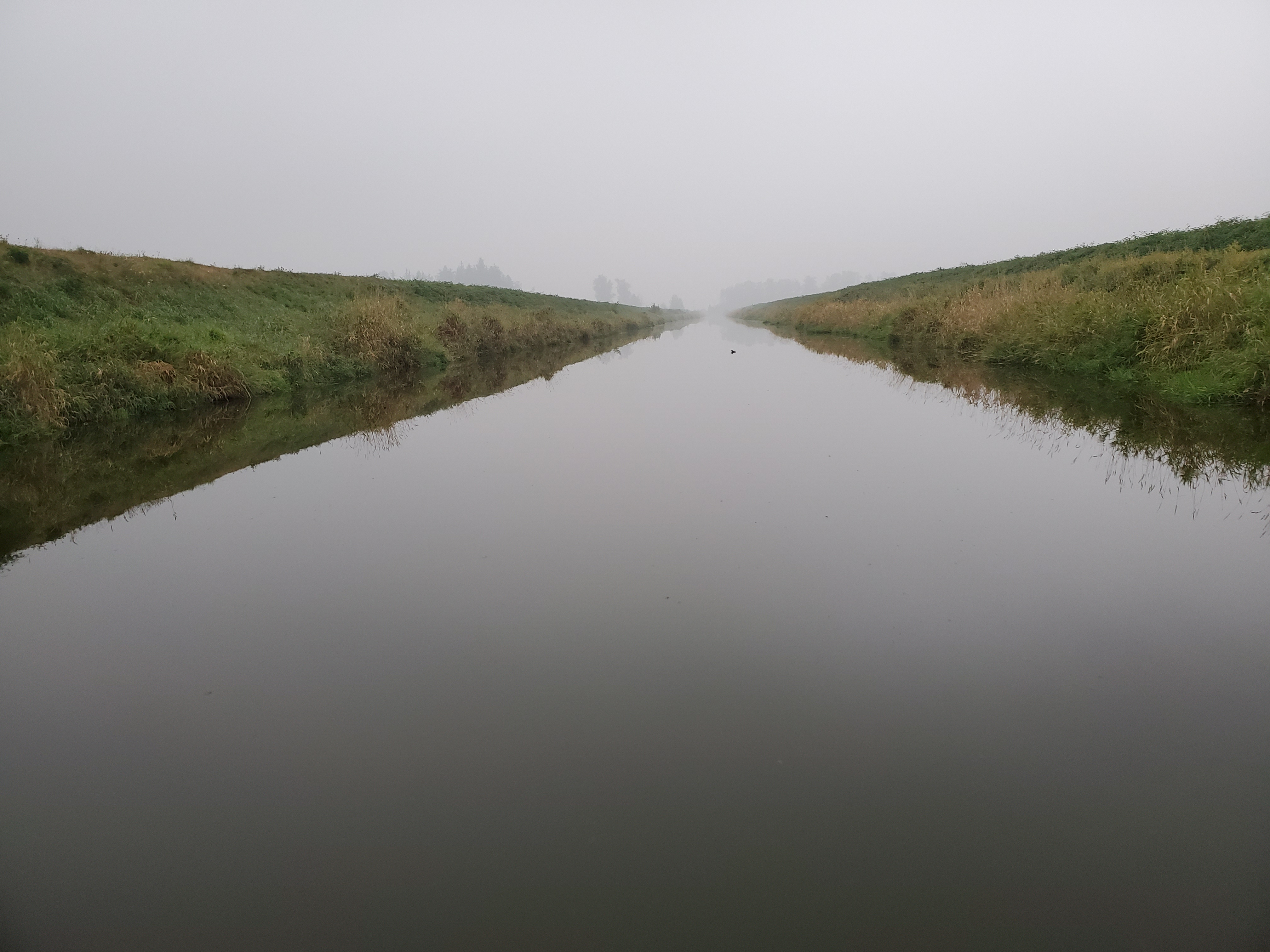
At the end of the straight arm, I made a right to head back north along the west arm of the circuit. Here the water seemed to be more stagnate with perhaps more farm run-off as there were a lot more surface algae.
Just after the bridge at 64 Avenue, the water gets visibly shallow. It may be that it is shallow throughout but this was the first section that I was paddling over that I could see the bottom.
I continued along the channel assuming that I would eventually be directed northeast when I reached the northwest corner of the triangular circuit. I passed a few artifacts that in hindsight should have alerted me (e.g. a row of pilings near the tributary of Bear Creek, the pump station (?) at the start of Bear Creek). These are all evident on the satellite version of Google Maps. But my naive navigating numero-uno did not know that the maps could be so inherently different. A lesson learned for future paddles!
Below is the map of the circuit that I thought I was completing.

The map below the classic ABC Challenge advertisement is the route that I actually took! I can see the difference. Can you see the difference?

And here is what went wrong that I discovered after the fact. Below is a comparison of the default and satellite views from Google Maps of the Serpentine River Circuit. Both views look relatively passable.
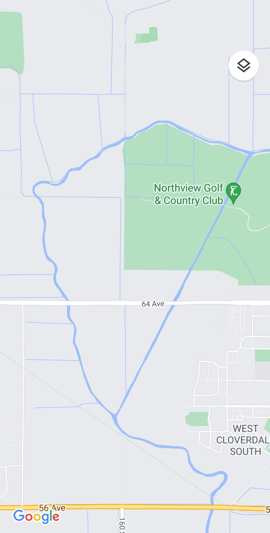
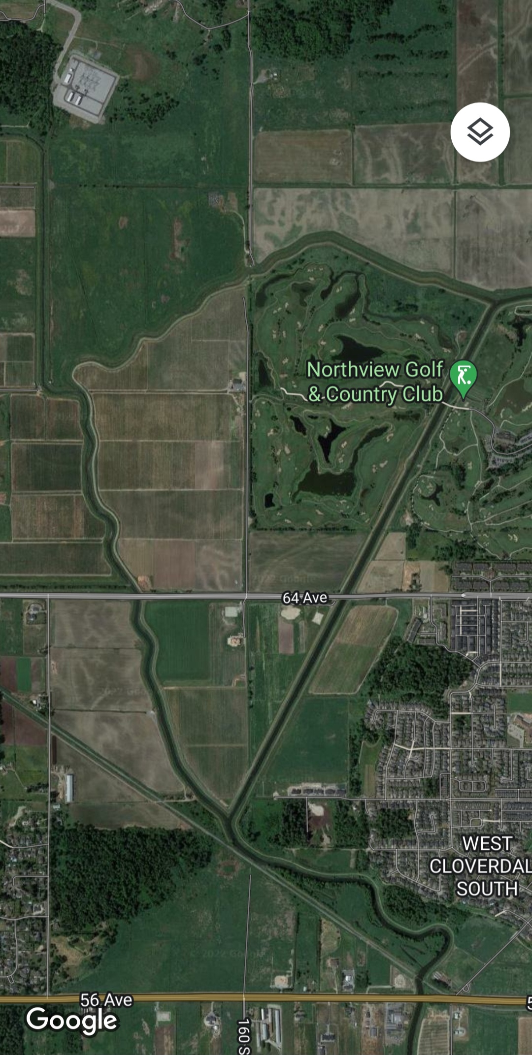
But, when you zoom into the northwestern corner of the map, things start to look different.


The satellite image above tells the real, slightly less welcoming story. No path to be found at all. And in real life, I did not even see an inkling of a creek. It was just trees which had me very confused at the time. And now that I had to travel all the way back, backtracking my route, I did not have the time to hang out and investigate.
It was a sprint paddle back to redo the majority of the circuit to make it home for a 10:00 Zoom meeting. I made it back home to my parking spot at 09:55 so no time to spare!
So, a valuable lesson of knowing to check the satellite view for Google Maps to get a better sense of the terrain was learned. The Serpentine River Circuit is a none scenic, peaceful, but slightly rank adventure paddle. But know that currently it is a not a circuit in the loop sense of the word.

3 thoughts on “Serpentine River Circuit‽”