
Ramillies Channel to Jericho Beach
Monday, September 5, 12022 HE
This post is the account of Day Three of my three-day, two-night stand up paddleboard (SUP) tour through Átl’ḵa7tsem (Howe Sound, click here for pronunciation). I launched from Locarno Beach and SUPed to Sxwan’shnm (Tantalus Landing Marine Recreation Site) on Day One (for details, see this post “SUP’in the Sound 2.0: Day One“). On Day Two, I started my return south, launching from Sxwan’shnm and paddling to ínaḵa Lhaxwm (Ramillies Channel Marine Recreation Site) on the east coast of Chá7elkwnech (Gambier Island, see here for pronunciation) (for details, see this post, “SUP’in the Sound 2.0: Day Two“). Day Three was the last leg of my return to Vancouver, launching from ínaḵa Lhaxwm and SUPing to iy’a’l’mexw (Jericho Beach). For details, keep reading.
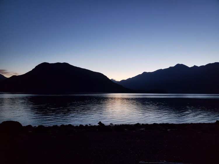
I was up early yet again to beat the inflow winds. I knew it would take longer to break camp with my tarp setup. The sea state was calm, and the tide was low. There had been no more rain since the late afternoon the previous day. I took down my tarp lines and packed up my wet gear. Twilight breakfast around 0600 hours on the beach was again Quaker Instant Oatmeal, this time Maple and Brown Sugar flavour, along with dried mangoes, an apple, and mixed nuts. See the pictures below for Helios heading to the horizon.

If your curiosity wasn’t piqued by my past post, perhaps I can persuade you to podcast at present. If you have ever wondered about the association of religious groups, particularly Protestants, to the breakfast cereal market (e.g., W.K. Kellogg, Quakers), check out this hot-take from The Blindboy Podcast titled, “Victorian Sex Communes and Breakfast Cereals.” And if you haven’t wondered, check it out anyways. The title alone piqued my interest after a client recommended the ‘cast.
But back to the paddle adventure…
I launched at 0640 hours on calm, flat waters. I was only 20 minutes ahead of schedule, compared to almost an hour the previous morning. The cloud cover was glorious as I made my way out into the Sound. I quickly checked Windy.com to see what the forecast for Səl̓ilw̓ət (Burrard Inlet) was, now that I had reception on the open water. The forecast called for westerly winds. But confusing the picture, the real-time wind reports at Jericho Sailing Centre, Point Atkinson, and Hollyburn Sailing Club, all showed easterly winds. I formed a few tentative plans in my mind that would be sea state dependent.
Below is my previously planned itinerary for Day Three. For the entire three-day plan, see here.
Original SUP FLOAT PLAN: Day Three
September 5, 2022
0700 🏄🏽♂️ ↗️ Ramillies Channel (7.5 km)
0840 🏄🏽♂️ ↔️ Halkett Point (3 km)
0920 🏄🏽♂️ ↔️ Finisterre Island (6 km)
1040 🏄🏽♂️ ↔️ Whytcliff Cove (5 km)
1140 🏄🏽♂️ ↘️ Point Atkinson
1210 🥘 ⏸ Point Atkinson
1240 🏄🏽♂️ ↗️ Point Atkinson (7 km)
1410 🏄🏽♂️ ↘️ Spanish Banks
1440 🚗 ↗️ Spanish Banks
1500 🚗 ↘️ Home
(~28.5 km)

The following are the real-time audible calls I was making in my head for a new float plan.
Option one, if the headwinds were too strong, I would shorten my paddle and get to Ch’ax̱áy (Horseshoe Bay, see here for pronunciation) or St’éx̱w’t’eḵw’s (Whytecliff Park, see here for pronunciation). Thankfully, I had both my father-in-law and friend on standby, with offers to rescue me if conditions called for it. Which option to contact would be more bruising to the ego was the real question.
Option two, if the winds at Ch’ax̱áy (Horseshoe Bay) or St’éx̱w’t’eḵw’s (Whytecliff Park) were manageable, I could continue up the coast towards Sḵ’íw̓itsut (Point Atkinson). From there, I would continue as planned, crossing Səl̓ilw̓ət (Burrard Inlet) to Ḵweḵw7úpay̓ (Spanish Banks) or iy’a’l’mexw (Jericho Beach).
Option three, if the winds were in fact westerly, I could hug the eastern shore of Nex̱wlélex̱m (Bowen Island) down the Queen Charlotte Channel and then cut across to Smelhmelhél̓ch (Passage Island), heading eastward into Səl̓ilw̓ət (Burrard Inlet). There would be a lot of unknowns with this option, particularly the sea state to the south, as the situation would be subject to shifting.
Option four, head to Nex̱wlélex̱m (Bowen Island) and try to use it as a wind shelter along the eastern shore. I could cross when convenient and continue to Sḵ’íw̓itsut (Point Atkinson) as per option two.
All of these possibilities were contingent on conditions, so onward ho!
The water was so peaceful and pleasant. Compared to Day One, it was flat and calm, with little to no wind. And compared to Day Two, there was no threat of rain and a promise of warmer weather. But along with the currently calm, no outflow wind, clear sky conditions came the threat of inflow wind when the weather warmed. Plus, leaving at low tide meant I would be working against the flooding current. But for the time being, I took in the sacred Sound surroundings.
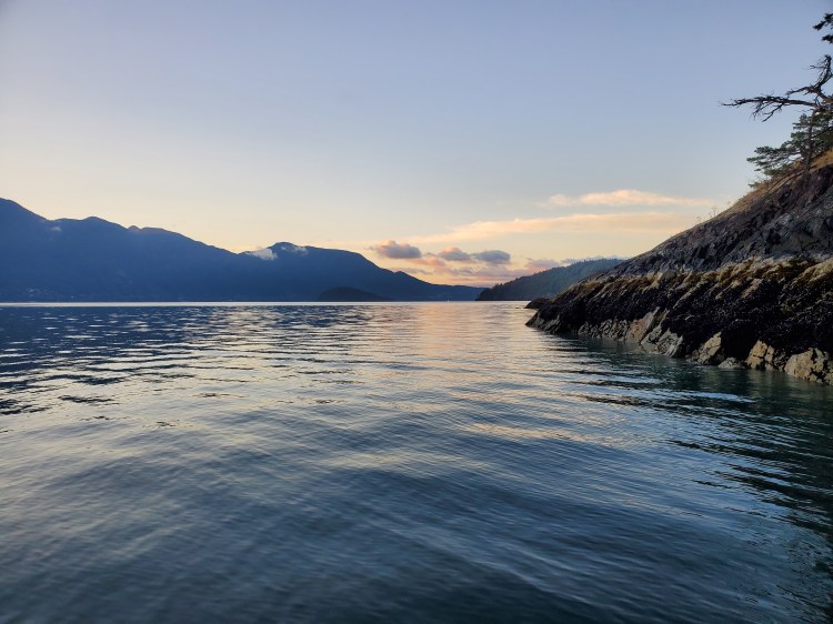
The image below is the view back towards Lhaxwm (Anvil Island, click here for pronunciation).

And some cool-looking clouds capping the view eastern shore over the Britannia range as the Sun ascents in the sky.

As I approached Halkett Point, I saw the Langdale ferry leaving Ch’ax̱áy (Horseshoe Bay). The ferry would be well out of the way, making my crossing toward Finisterre Island easier. I would also be able to see the ferry coming back from Langdale at a distance, or so I thought.
I saw a lone fishing boat out before reaching the point. The only vessel I had encountered so far, apart from the one moored at Ramillies Channel when I launched. Interestingly, at Halkett Point, I spotted a no-fishing sign on the cliffs. I wondered what the reasoning was and where exactly the area extended? A later search revealed that it was for glass sponge reef conservation and was just a small area directly off the point.
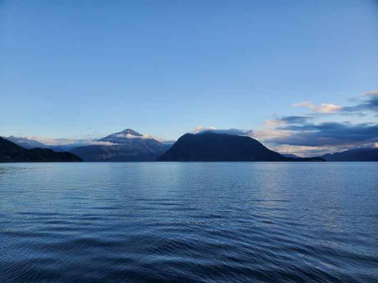
After seeing the Langdale ferry travelling westward, I wanted to get far enough past the point to see the ferry for its return route before taking a paddling break. But the point felt like it just kept getting further. The angle needed to see the Langdale Ferry Terminal was much further than I remembered. I eventually gave up, as I didn’t necessarily want to take my break in the travel line of the ferry. Reaching a point where I could view the terminal was starting to feel like it would put me right in the path. So, I stopped for a snack and my first on-board micturition mid-water. The image below is the view back toward Lhaxwm (Anvil Island) from my rest stop with Mount Wrottesley to the left, crowned by clouds.
Replenished and relieved, I started the crossing to Finisterre Island. I was well into the channel before seeing the Langdale Ferry Terminal, so my early, no line of sight, break proved to be a wise decision. The southeasterly winds started to pick up as I approached Finisterre Island. I took another brief break in the leeward shelter of the northern shore of the island. I decided I would start the section of the southerly leg heading down the east coast of Nex̱wlélex̱m (Bowen Island). As I rounded Finisterre Island and entered Cates Bay, I questioned my decision. The winds weren’t unmanageable, but it was going to be a slog with a strong headwind. I started to worry about whether the winds would be southwesterly further south?
Just off of eagle cliff I came across a galaxy of sea stars. I couldn’t find a credible source but there were sites that suggested a collective of sea stars is called a “constellation”. The sighting was a bit ironic since we had searched for sea stars on a recent holiday to Vancouver Island and had not seen any. Here they were, a whole lot of them! A constellation in fact.
In the bay between ‘eagle cliff’ and the point near Miller’s Landing, I spotted another SUPer heading north. We were on course to cross paths, but then I saw the Snug Cove ferry leaving from Snug Cove. The Nanaimo ferry had departed earlier, so it would be coming from Vancouver Island next, and I’d see it from a far rounding Point Cowan at the southeastern corner of Nex̱wlélex̱m (Bowen Island). With the winds coming from the southeast, I decided to seize the ferry window and cross toward Ch’ax̱áy (Horseshoe Bay) to try my luck on the eastern shore. I cut out into the channel. Thankfully, the winds seemed to ease some as I SUPed out.
There was no sign of the Nanaimo ferry as I made my way across the Queen Charlotte Channel. The conditions were quite calm. Much calmer than my most recent crossing. For the entire account of that crossing, see this post title, “All Gale the Queen.” Closer to the eastern shore, the waters were more turbulent, with the waves rebounding off the cliffs. I can’t say that the conditions were better on the eastern side, but I was closer to my destination. I continued to Whytecliff Cove, where I stopped for a snack break. Checking my phone to update my family with my ETA, I saw that my father-in-law had messaged saying he could come and meet me on his sailboat. He moors at the Thunderbird Marina in Fisherman’s Cove, so it was close. We met at the south side of Batchelor Cove and travelled together towards Sḵ’íw̓itsut (Point Atkinson). He left me to sail for a bit after Batchelor Point to be further out in the channel closer to Smelhmelhél̓ch (Passage Island). But not before capturing some footage of my float.
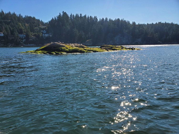
The two small southernmost rocks of the Grebe Islets were scattered with seals. I was going to paddle between the larger northern islet and the smaller southern islet but was worried that I would disturb the seals as I approached. I decided to turn back and pass on the eastern side of the smaller southern islet. As I backtracked and came around to the east side, I was dismayed with my decision as a double-pedal kayak that had just rounded the larger northern islet took the path I had avoided without disturbing the sleeping seals. I suspect the kayakers being lower to the water and not needing to move their upper extremities for propulsion played a part. At least that’s what I told myself at the time. The image below is the smaller southern islet before I turn back.
Once on the other side, I re-rendezvous‘d with my father-in-law, and we travelled up to Sḵ’íw̓itsut (Point Atkinson). There, we parted ways, and I stopped for lunch here, just west of the lighthouse. I was thankful for the escort as it gave me an extra energy boost when my reserves were waning. On shore, there was a family with two young children doing some seashore exploration. We chatted briefly. They were curious about where I was coming from with so much kit and were surprised by my response.
For lunch, I had Indian Red Lentil Stew by Nomad Nutrition. It was the curry fix that I was craving, topping the not-up-to-expectations Kathmandu Curry from yesterday. From there, it was the final leg across Səl̓ilw̓ət (Burrard Inlet). I confirmed my pick-up point before departing. Then I was off. I cleared the point and checked for any large vessels coming into the inlet. The coast was clear (pun intended), and I was off. I alternated between heading directly for the Jericho Sailing Centre and a more north-to-south route so that I could ride any westerly waves. Once I felt I was far enough through the deep-sea transit route for safety, I stopped for a quick photo. The cumulus clouds covering the city were a spectacular sight.

Knowing that the origins of Labour Day have a darker history than the happy-go-lucky holiday we’ve come to enjoy was a striking juxtaposition from my serene seafaring sanctuary. Here I was, enjoying a holiday at a time when work conditions are more than cushy in such beautiful surroundings. It was a moment to reflect and be grateful for my many good fortunes. Many lives less fortunate were lost in the labour struggle, some by accident and others by intention. Lives were lost in the development of, and movement for, our current vocational conditions. To hear an account of the labour movement struggle through an American lens, check out NPR‘s Throughline episode titled “American Socialist.” It tells the story of a labour movement conflict against the nineteenth-century railway industry’s benevolent capitalism communities. Coincidentally, the book I’m reading paralleled these thoughts as the section on sleep I had read the night before questioned where the myth of the eight-hour requirement originated. The original source of this sleep slogan is unknown, but there is speculation that it comes from the late nineteenth-century labor movement in which there was a shouting call at rallies for “Eight hours for work, eight hours for rest, and eight hours for what we will!” (Lieberman 80). But the lore is a lie. We have no basis in believing that eight hours of sleep for an adult Homo sapiens is necessary nor optimal. Lieberman references studies of hunter-gatherers averaging 5.7 to 7.1 hours with longer durations in winter months (81) and westerners ranging from 6.5 to 7.5 hours (80). The take-home message is don’t believe everything you hear without some supporting evidence, and don’t beat yourself up if you’re not getting eight hours of sleep. Chances are that’s normal and probably healthy.
While stopped, I even took a few short videos. The one below is a panoramic pan.
And this one was my attempt at a full 360-degree view.
In the end, the southerly winds felt more prevalent, so I trended toward the angular approach to iy’a’l’mexw (Jericho). It was only a seven-kilometre crossing, but at the end of my third day of paddling, it felt like it was dragging on forever. I finally made it to the other side of the moored freighters at the south side of the bay. The freighters are frighteningly large when crossing in front of the dormant beasts. Especially, when my imagination worried that my mere presence might rouse the monsters from their rest. Thankfully, no engines roared to wake. I was on the home stretch with the wind now at my back for the final push to iy’a’l’mexw.
I landed to an imagined fanfare. Normally, I am extremely cautious about leaving my SUP along the shore on touring trips as I am terrified that my vessel could be washed-out unsuspectingly. However, amid the confusion about where my pick-up place was, I walked some gear up to the parking lot, leaving my board behind on the shore. I thought I pulled my board up high enough, but it turned out, I didn’t. Perhaps I spent more time away from the rising tideline as the walk was far, and I conversated with my kids. In any case, I returned to the shore to find my board spun 180 degrees around, but thankfully onshore. Confused, I asked/thanked the representative from Windsure, who was setting up a pair of kayakers to head out if he had pulled my board up. He didn’t say it was him, but stated my board was swept out into the water, and someone had pulled it ashore. I looked around for that someone to thank, but no one appeared to be my Good Samaritan. Whoever they were, they saved me an embarrassing swim, and it is a lesson that I won’t soon forget. My previous vessel parking paranoia was not misplaced and, thankfully, I was only partly punished in possibly the least painful way to never permit such a puerile pretermission.
All-in-all, my three-day touring adventure in Átl’ka7tsem (Howe Sound) was an incredible experience. I had a beautiful blend of weather conditions and sea states. I was fortunate and grateful for the help and good luck I received in the preparation, execution, support, and weather. SUP’in the Sound is now one SUP bucket-list item checked off. But, I’ll be sure to do more adventures through the fjord in the future.
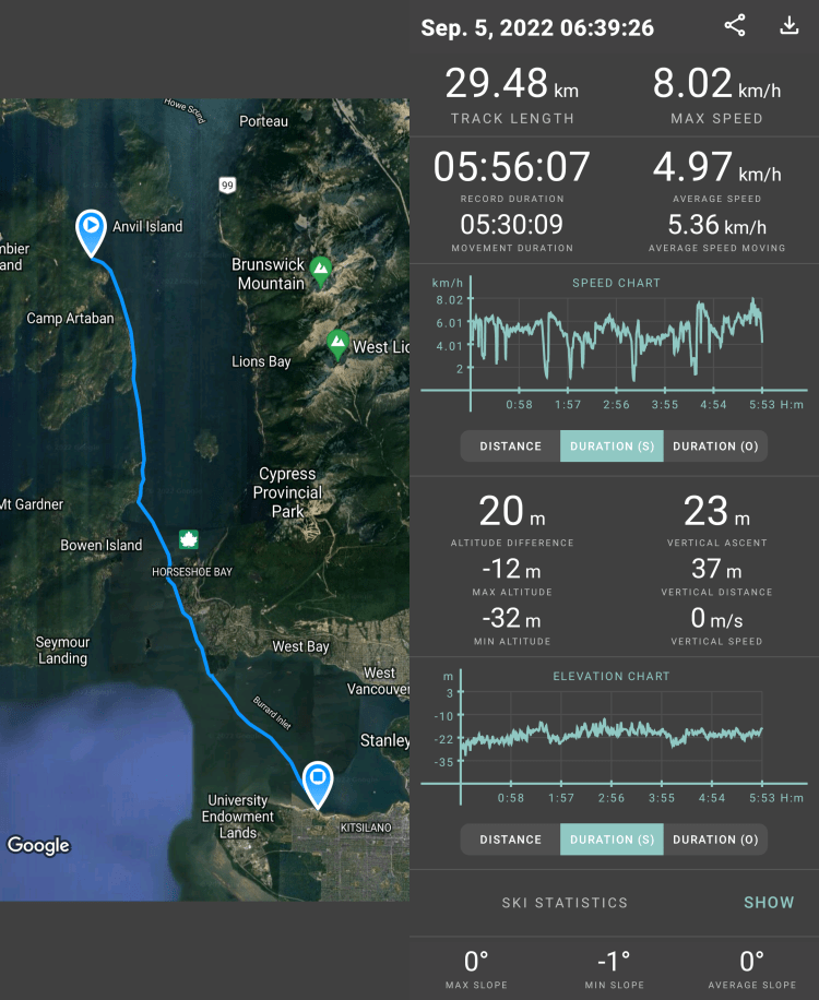
The image below is my route for Day Three and statistics recorded with Geo Tracker.
The video below recaps my route created on Relive from the Geo Tracker data, and gives the images throughout the post more context. If the video below doesn’t work, here is a link to the video on Relive’s site.
Until the next adventure…
Citations
Lieberman, Daniel E. Exercised: Why Something We Never Evolved to Do Is Healthy and Rewarding. Vintage Books, a Division of Penguin Random House LLC, 2021.

One thought on “SUP’in the Sound 2.0: Day Three”