
Saturday, June 25, 12022 HE
This paddle has been on my to-do list for a long time. I first read about the possibility on Norm Hann’s website. Somewhere in my searches of his material, I came across a post about crossing from Ch’xay (pronounced Chai-hai, Horseshoe Bay) to Xwlíl’xhwm (meaning “Fast Drumming Ground”, a.k.a. Snug Cove) on Nex̱wlélex̱m (Bowen Island) for breakfast and coffee at the Snug Cove Cafe. The idea of paddling to Nex̱wlélex̱m one morning for coffee and breakfast was thus born. That was almost two years ago.
A recent conversation brought up the mouth of the Sound, and the idea of a coffee run to Xwlíl’xhwm (Snug Cove) was resurrected. After polling my paddle posse for interest and potential dates, Trevor suggested June 18. It was the day before Father’s Day, and he reasoned there was a high probability our wives would be willing to accommodate. Now we just needed to settle on the details (departure time and location) and hope the weather would work in our favour. But as the date approached, we made a scheduling change to the weekend after Father’s Day. The switch turned out to be a great call as Junuary was still in full force for the Father’s Day weekend. And lo and behold, summer arrived just in time for our paddle after the passing of the summer solstice!
The forecast was calling for a warm sunny day. Naturally, I assumed that would mean a morning outflow and an afternoon inflow (I’ve been learning about the along-channel winds in the Sound for a post). But prior to my deep dive into getting “Down with the Sound” I had assumed the morning outflow would be relatively light. In hindsight, it was no surprise that the initial forecast was for “strong” outflow winds. Leaving in the morning meant that the temperature and pressure gradient that drives the fjordal wind system was in favour of outflow. But for some reason, my mind was set on getting an inflow, especially with the change to warmer weather. Wishful thinking, I suppose.
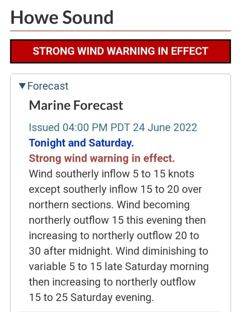
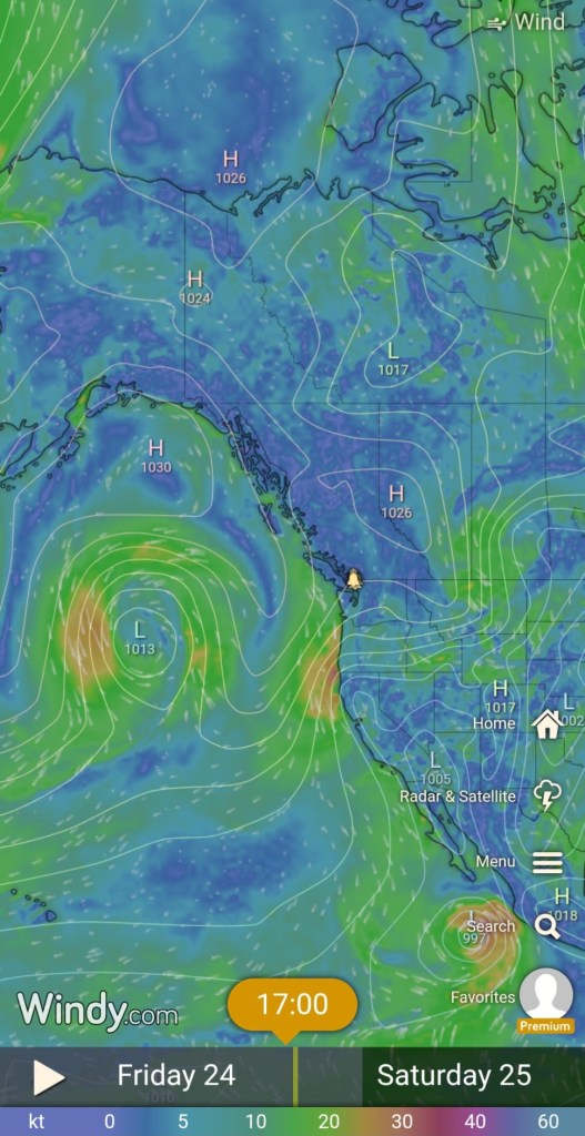
Upon reflection, I doubted the forecast because it was calling for outflow winds all day on Saturday, despite clear skies and warm weather. In my mind, those conditions meant an afternoon inflow for sure. I surmised that the stronger and longer outflows were a result of the wider synoptic wind patterns. When I looked at the wider picture on Windy.com, my hypothesis was confirmed. At least that’s what I am saying, knowing full well that it could be a case of the false cause fallacy. The British Columbian coastline had a low-pressure system offshore and a high-pressure system inland. I guessed that the pressure gradient was causing the stronger outflow and possibly going to maintain it despite the local thermal effects. 🤔
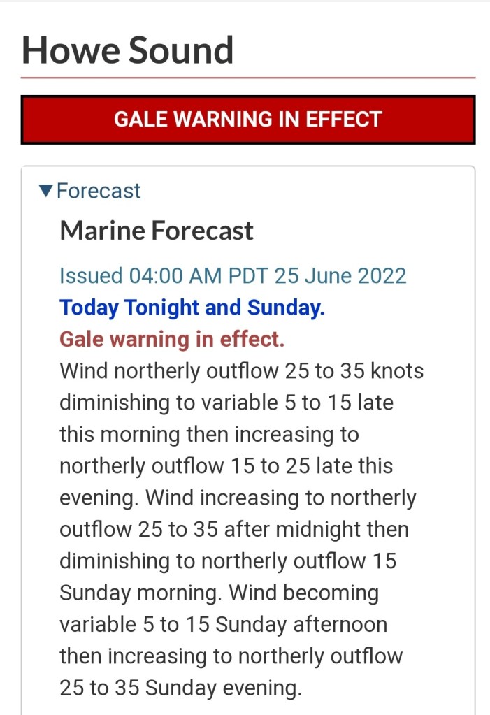
In the morning, I was surprised to see that the “STRONG WIND WARNING” had been upgraded to a “GALE WARNING”.
Our original plan was to cross the Queen Charlotte Channel, launching from Whyte Cove and landing at Xwlíl’xhwm (Snug Cove). However, with the strong outflow forecast from the Friday evening, Trevor and I had a backup plan of launching from further north, Ansell Point or Lions Bay, to take advantage of the outflow wind. But if the wind didn’t change direction, or at least ease, by the late morning/early afternoon, that would make for a tough northerly leg. Not exactly the ideal setup for the second half of your paddle. Another option was to scrap the crossing altogether and do a downwinder either in the morning north to south or in the afternoon south to north further up Átl’ḵa7tsem (Howe Sound). But that option still carried the unknown of the forecast being in opposition to what I assumed the local wind patterns would be. I’ve noticed that Windy.com tends to predict the wind speeds in Átl’ḵa7tsem as lower than what is reported at weather stations (e.g., Point Atkinson, Pam Rocks, Squamish Windsports Society). That was part of the reason that I didn’t trust the forecast. The rest was wishful thinking and stubbornness to complete our plan, sprinkled with a touch of meteorological insight. In any case, we decided to check out Whytecliff Park and decide what to do from there. Below is the float plan I set up pre-paddle that our loved ones had.
SUP FLOAT PLAN: Whytecliff Park to Nex̱wlélex̱m (Bowen Island)
DATE: Saturday, Jun. 25, 2022
ROUTE: Whytecliff Park to Bowen Island (Snug Cove)
VESSELS: Green/Blue (white/orange trim) NSP Carolina SUP, White/Red AirSUP iSUP
EST. DEP.: 0715
EST. ARR.: 0800
Details:
Tides (Point Atkinson)
•0241 High 4.2 m
•1015 Low 1.1 m
•1754 Low 4.1 m
Wind
•Forecast: see Windy App
•Northerly (NNE, NNW) 2-5 kt (10 kt wind gusts) changing to westerly 3-5 kt (10 kt wind gusts)
*Howe Sound GALE WARNING
Daylight: 0508 – 2122
Drive Time: ~32 minutes (one-way)
Paddle Distance: ~3.5 km (one-way)
Paddle Time: ~0.8 – 1.5 hr
Personal Info
TRAVELLER(S): 2 (Mon Jef Peeters, Trevor Mazurek)
VEHICLE: [Colour] [Year] [Make] [Model] [ABC 123]
PHONE: [xxx-xxx-xxxx]
Itemized Itinerary
•0600 🚗 ↗️ Home
•0645 🚗 ↘️ Whytecliff Park
•0715 🏄🏽♂️ ↗️ Whytecliff Park (3.5 km)
•0800 🏄🏽♂️ ↘️ Snug Cove
•0830 ☕️🍳⏸️ Snug Cafe
•0930 🏄🏽♂️ ↗️ Snug Cove (3.5 km)
•1015 🏄🏽♂️ ↘️ Whytecliff Park
•1045 🚗 ↗️ Whytecliff Park
•1115 🚗 ↘️ Home
I had rechecked the weather in the morning, and when I saw the upgraded “Gale” warning, I checked the Howe Sound Living webcam. It looked wavy, but it wasn’t a deterrent. Before the wind speed upgrade, I had been more concerned about the tide. We would be crossing the channel around the maximum ebb, and I knew that meant we needed to be aware of the current. I had crossed Queen Charlotte Channel before under similar conditions, and the water was fast-moving. Now we would have the wind working against us too.
As we drove into Whytecliff Park, we surveyed the waters in and around Batchelor Cove. The cove was calm, but you could see the water was moving south with some speed out in the channel. A quick check on the trees further into the park confirmed they were moving, a sign of gale-like conditions on the Beaufort wind scale. We decided to survey the seas from the Whytecliff Lookout Point. Walking up to the lookout, we could hear and feel the wind. The view from the point gave us a straight shot of the water conditions over to Xwlíl’xhwm (Snug Cove). As I expected, the waves looked bigger in real life than they had on the Howe Sound Living webcam in the morning. We discussed our options. The winds looked strong, but we figured we could make the crossing. At least we would try, and if the wind and current proved too strong, we could turn around and get pushed back to our launch site. Had the wind been in the other direction, I don’t think we would have been as comfortable or cavalier. The northerly winds gave us a safety net with a northbound route that we wouldn’t have had in a downwind scenario.
As we walked back to the car to relocate to the main parking lot we were both chilly. The gale winds in the shade were cold. We decided to go with extra layers. I wore 1.5 mm neoprene pants with two synthetic tops, one long-sleeve and one short, plus a hat. I topped my outfit off with my PFD instead of my inflatable waistbelt PFD for an added layer of insulation. I was anticipating a submersion somewhere along our route. Trevor went with running tights, board shorts, a synthetic long-sleeve, topped with a windbreaker, PFD, and toque.
It was calm in the confines of the cove as we set out.
Outside of the shelter of Whytecliff Point, the conditions were manageable. It was choppy with a strong wind, but we were making headway. And now that we were in the sun, it was pleasantly warm. We had dressed appropriately. We knew the 0625 Nanaimo ferry (Nanaimo Harbour to Horseshoe Bay) would be near us around 0745 (the sailing duration is 1h 40m). With our 0730 launch, we needed to be wary of our crossing as we would pass directly through the ferry line. Before pushing into the channel, I quickly checked where the ferry was on my Marine Radar application. It was far enough that we would be able to cross.
The winds became stronger as we made our way out into the channel. They became more of a crosswind blowing from the northeast, making navigation challenging. It was harder but more stable to paddle upwind, yet easier but tippy paddling with the crosswind. There was also the business of getting out of the ferry lane, which had me willing to take the tippiness to cover more distance. The gusts were fierce in the middle of the channel, and I alternated between paddling directions. I veered upwind when the winds gusted and crosswind when they eased.
I tried to keep a watch over my left shoulder for the ferry. Eventually, it appeared from around Cowan’s Point. From a distance seeing the ferry messes with you. To me, it always seems that it is heading right for you. I called out to Trevor over the wind, “Ferry!”
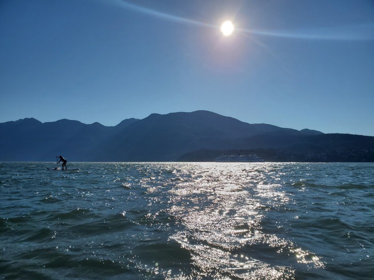
Thankfully we had made enough progress already that we didn’t need to fret. We kept up our pace, changing to a more direct line toward Nex̱wlélex̱m (Bowen Island) until certain we were out of harm’s way. I paused to take the picture below. Initially, I had tried to capture Trevor’s silhouette backed by the ferry. But while fumbling for my phone, I was blown off course. The picture still turned out okay.
The wind remained relentless. For some reason, in my mind, I kept thinking (perhaps wishing) that it would die down with the heat. If anything, it was the opposite. It was stronger.
A short time after the ferry passed, the first of the mermaids came out. It could have been the ferry wake mixed with the wind chop and tidal turbulence or the mythical aquatic creature, but soon enough, Trevor and I had both plunged into the water in pixie pursuit. The water was refreshing. It was a bit cool when remounted, wet in the wind, but the work of waging our way onward into the wind was warming.
I forged forward for the photo below. Trevor is centre image, Nex̱wlélex̱m (Bowen Island) is on the right, with Passage Island, Point Grey, and Point Atkinson lying to the left.

The image below is the view to the north. Bowyer Island is in the centre. The snow-speckled peak rising above Bowyer is Brunswick Mountain, with Mount Harvey to the right. The Lions are obscurely visible to the right of the valley off of Mount Harvey.

The water near Dorman Bay looked calmer, so I made my way over. I rode the small wind waves into the bay. The southeastern tip of Dorman Point provided a windshield. I took advantage, paddling up along the sheltered coastline. On the other side of the point, the wind waves were a bit less chaotic than in the open water. I took advantage of the cleaner conditions to do a few short “surf” runs back into the bay.
Then it was back into the wind to get around Dorman Point to Xwlíl’xhwm (Snug Cove). There were more mermaids in these waters, and again, the sea nymphs managed to coax me into the water. Or perhaps they were Nereids?
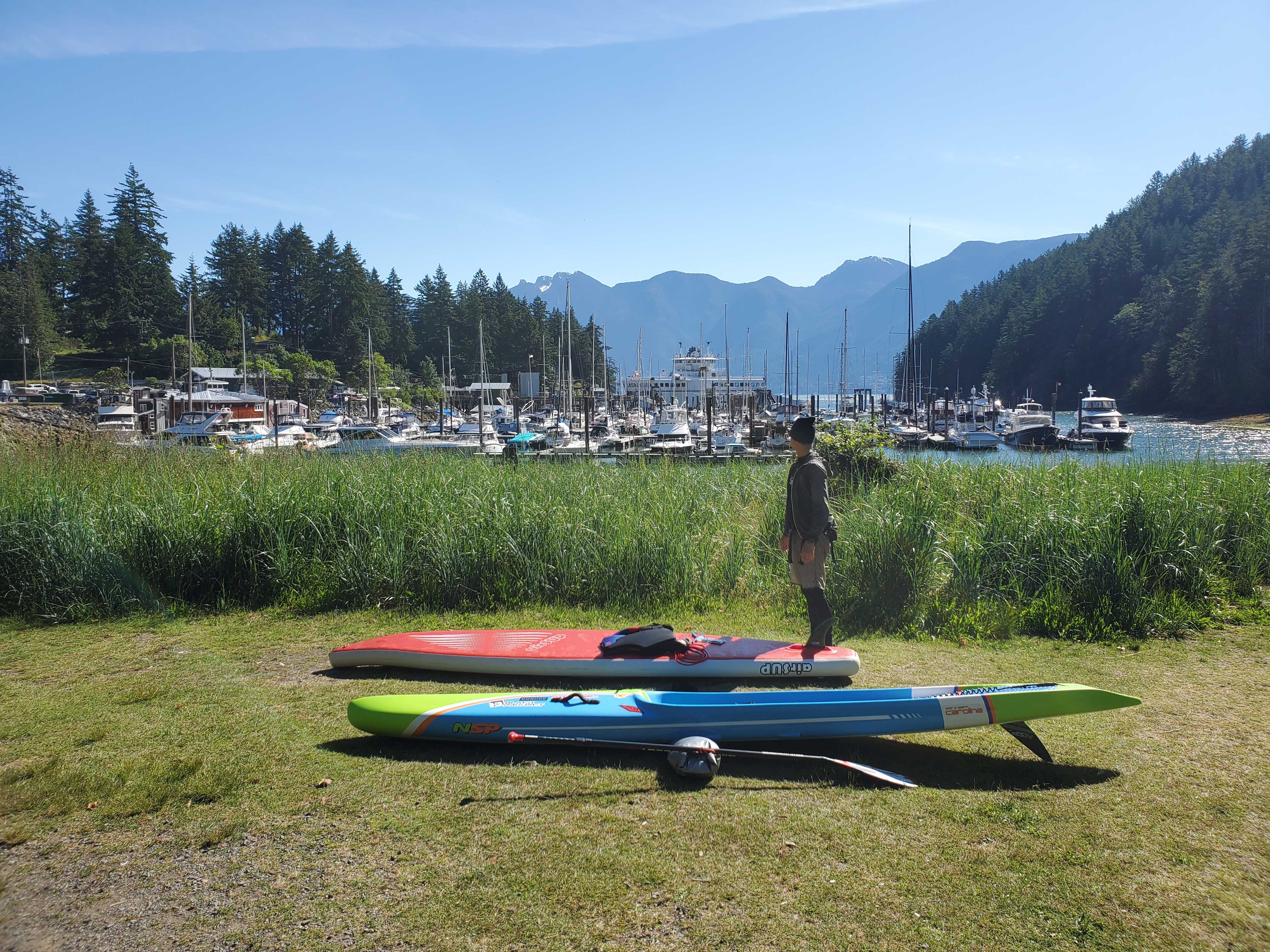
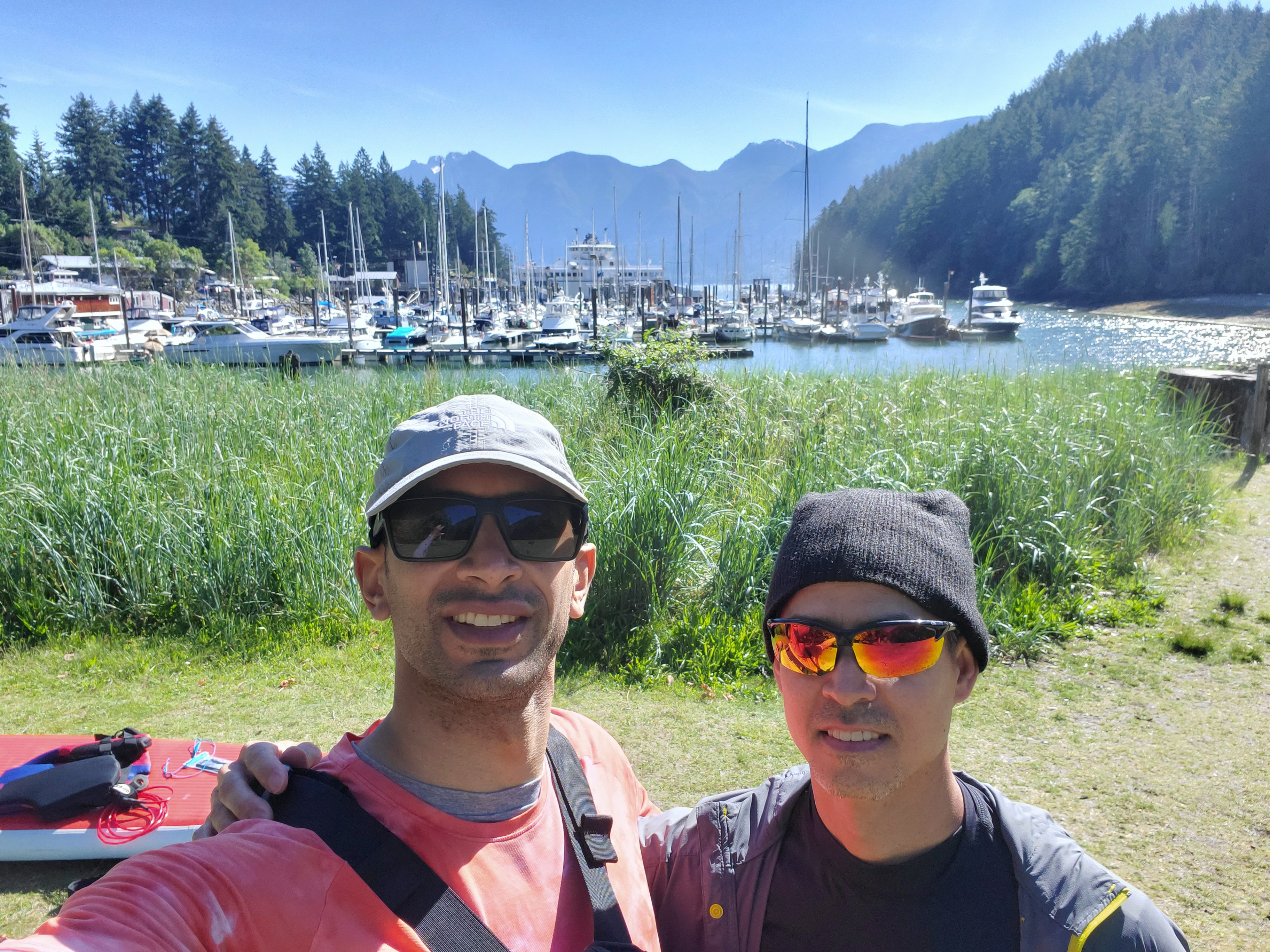
The rebounding waves coupled with strong northeasterly winds on the east side of Dorman Point made for the most challenging paddling yet. The waters were a turbulent mess. We managed to get around the point and then make our way leisurely into Xwlíl’xhwm (Snug Cove) with the wind at our back. We landed at the beach at the shore of Bowfest Field in Crippen Park and brought our boards up to the grassy area at the end of the seaside boardwalk. We paused for a celebratory photo op before making our way up to the Snug Cove Cafe.

We stashed our boards across the street from the cafe in the grass and got in line. We were much later than anticipated. My original trip itinerary didn’t account for gale winds. As we waited in line, I checked out our route. I had estimated 3.5 km to cross, so I was surprised that our journey had taken nearly 7.2 km. That was a lot of water treadmill and only a touch of water play!
As we were still wet from our last maritime maiden submersion, we found a sunny spot to stand while we used a dry bag as a placeholder. After a long-deserved wait for breakfast and coffee, we enjoyed a well-earned meal. Trevor had the breakfast bowl, and I had the Snug Cafe breakfast. Apparently, we were ravenous as we didn’t even consider food porn pics.
We basked in the sun. Man, was it nice to have done this paddle in the warm weather, we mused! Sitting around under overcast skies the weekend before would have been horrible.
Then it was high time to get out of there. We checked the current conditions at Pam Rocks. The winds were still northerly but much lighter. As we made our way down to the water, we joked more about our weather luck paddling together in Átl’ḵa7tsem (Howe Sound). Last summer, we had tried to SUP from Horseshoe Bay to Squamish on a multiday trip only to be stymied by strong northerly outflows mid-voyage. Today’s leisurely breakfast paddle had turned into an upwind battle.
Back at the shoreline of Bowfest Field, the water was calm. The view of the Britannia Range over the Union Steamship Marina was spectacular. Initially I thought it was the Lions rising up in the background. But as Trevor and I discussed their proximity and I recalled that you can easily cross from the West Lion to the East Lion, I realized that it couldn’t be them. Later, looking at a map post paddle, I realized I mistook Mount Harvey for the West Lion. As we left Xwlíl’xhwm (Snug Cove) we checked for ferries. The coast was clear.

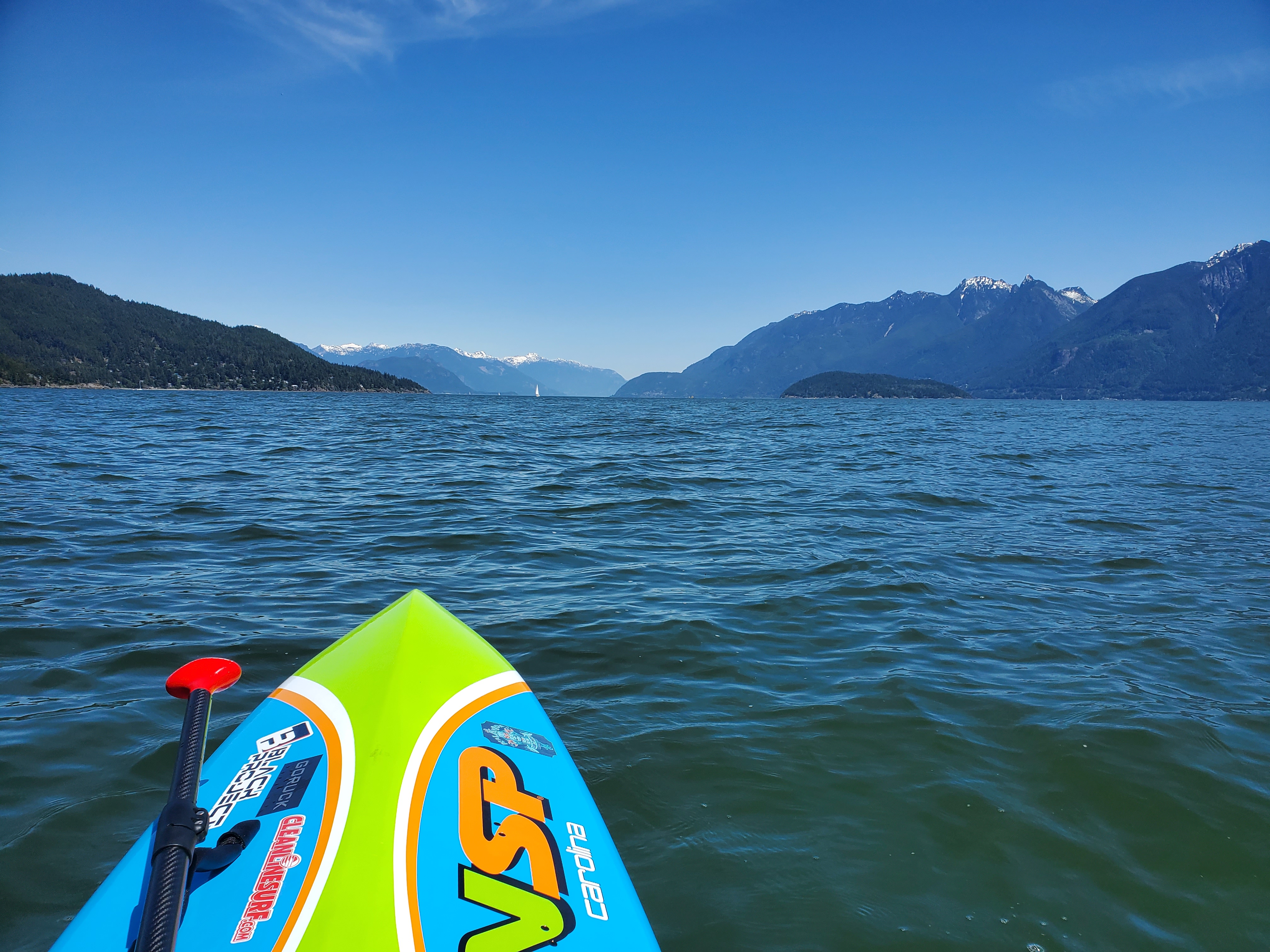
It was a much more pleasant return paddle. The winds had shifted. We were still getting a crosswind, but they were now from the southeast but much more mild. The waters were still active but much more manageable. The photo below is Trevor in the Sound with the Britannia Range of the North Shore Mountains in the background that runs along the eastern flank of Átl’ḵa7tsem (Howe Sound).

The images below are views slightly more westward, looking up Átl’ḵa7tsem (Howe Sound) with the Pacific Ranges in the skyline.

Near the middle of the channel, there was a section of rolling waves. I was able to string a few bumps together for some fun rides. I backtracked, hoping the area was something to do with the current or seafloor, but the waves were gone. The butterfly had flown.
We landed at Whyte Cove on a busy beach bustling with scuba divers, sunbathers, beach goers, and paddleboarders. Trevor and I ditched our extra gear on shore. I was keen to give Trevor a try of my new board and try to catch some boat wakes in the bay. Selfishly, I was hoping that him trying my board would be an inspiration for him to get a longer performance hardboard. We caught some wakes from a few smaller vessels that passed by closer to the mouth of the cove while waiting for the Nanaimo ferry to get closer. We traded back to our respective boards and did a final run for the ferry wake. Unfortunately, it was a bit of a letdown. There was too much noise in the waves from the wind chop. But hey! It was sunny, we were on the water, and we had just completed our first Snug Cove Coffee run. Not a bad little Saturday. Life was good!
Below is a comparison of our outbound and return journeys recorded with Geo Tracker. It was a 4.1 km return trip compared to the 7.2 km it took us to get there.


And below are recaps of our routes created on Relive from the Geo Tracker recordings. Click these links if the video below doesn’t work for the outbound and return routes.

2 thoughts on “All Gale the Queen: Bowen Island Coffee Run”