
Saturday, September 4, 12021 HE
The Sea to Sky Marine Trail

- The Sea to Sky Marine Trail
- Introduction/Inspiration
- Preparations
- The Plan
- What About the Weather?
- Timing the Tides
- Our Kit
- Ferdinand’s Sailor Lore
- Launch Time
- Ferry Tales (Not Fairytales)
- A Welcoming Start
- Sea to Sky Waterway
- Lunch Time
- The Squamish squamish
- Audible Around Anvil
- Ramillies Channel Rerouting
- Camp Mazu-pee
Introduction/Inspiration
This trip was the culmination of many separate but intertwined threads. Here are some of those distinct but related experiences. A childhood growing up in Squamish. My parents’ passion for nature and taking us on summer hiking and camping trips. Canoeing in the Squamish Estuary as a kid with my childhood best friend and his family. A canoe trip around Bowron Lakes (see here for the BC Parks webpage) with my future wife, which opened my eyes to watercraft touring/camping. My brother getting an inflatable SUP that I borrowed on several summer trips. My wife giving me the same SUP for my 38th birthday. Bringing that SUP to Hawaii for a family vacation and developing an interest in the activity (warm water helps!). A pandemic providing the opportunity to foster a passion for a new pastime. An inspiration to try SUP touring. A childhood friend’s goal to one day cycle from Squamish to Vancouver permeating into the plan to paddle the path in place. A one-night trial SUP tour around Nex̱wlélex̱m (Bowen Island, click here for a great video on the pronunciation) departing from Ḵweḵw7úpay̓ (Spanish Banks). All of these and many more experiences built up to this trip. All that, along with stumbling across the Sea to Sky Marine Trail on the BC Marine Trails website, while searching for interesting places to paddle culminated in the plan to paddle to Squamish.
Preparations
My goal through the winter and spring was to attempt this trip for the end of the summer. My preparation through the winter and spring included getting comfortable and proficient in downwind conditions. In the spring, I did a trial paddle with my board loaded with all my camping gear. And then it was time for the wet run, a circumnavigation of Nex̱wlélex̱m (Bowen Island), which fortunately was a dry run without any capsizes or mishaps. That trip was a solo, single-night trip, where I camped on Little Flower Islet, next to Hutt Island. That trip was originally going to be to Gambier Island (Cha7élkwnech), but the province-wide fire ban made me reconsider my options (see here for details).
Communication Connectivity
While planning, I looked into the cellphone reception for my provider, Telus, on Gambier Island. There was no reception at the Ramillies Channel (ínaḵa Lhaxwm) campsite at that time. However, now the Telus site shows coverage at the site. Always being a skeptic, I wasn’t going to rely on the accuracy of the Telus site to inform my safety plan. I would pack my VHF Marine Radio for this trip and paddle with a partner. Somehow, three days on the Sound solo seemed slightly less safety secure. I also received an early 40th birthday present from my family, a Garmin inReach Mini satellite communicator. So, I had backups on communication for safety.
Of note, I had a terrible time getting cellphone reception outside of a few select places on the beach. Trevor, whose provider is Fido, had a much better reception with his cell phone. Even satellite communication with the inReach seemed to be challenging. I attributed the difficulty of getting a signal to the cloud cover and forest canopy. Though, it may have been more my preconceptions regarding the speed of satellite communication. Which, it turns out, is much slower than I had imagined.
The Plan
I had contemplated completing the trip as a one-way voyage with a pick-up for assistance. But after my successful circumnavigation of Bowen Island (Nex̱wlélex̱m) and securing a paddling partner, I concluded that we could complete the round-trip journey. We set our sights on the September long weekend, and I started a deep dive into the planning details. With the greatest unknown being how challenging the Átl’ḵa7tsem (Howe Sound) anabatic winds would be? I’ve paddled in Átl’ḵa7tsem before (Bowyer Island, Porteau Cove, Squamish to Britannia Beach, Squamish River Estuary), but never at the northern tip with the winds at their peak. To get a sense of how strong the winds would be and their diurnal pattern leading up to our trip, I kept an eye on the Squamish Windsports Society weather page, which provides real-time data on the weather conditions at the Squamish Spit, and the weather data from Pam Rocks. The Squamish Windsports Society page is great because you can get real-time as well as historical data. For Pam Rocks the Past 24 Hour Conditions of weather data is easily accessible (as well as historic data here). I was curious to see if there were any discernable trends in the wind patterns diurnally. At first, it seemed that there was a consistent reduction in the wind speed around 19:00. But as I tracked the data more, it appeared that this was an anomaly. The observable trend that I could see was that the wind was strong and southwesterly. That would be great for our arrival, but not so great for our return trip.
I also planned to reward the first day of our trip with a celebratory beer at the Howe Sound Brewpub. The plan was to set up camp at Tantalus Landing Marine Recreation Site (Sxwan’shnm) before continuing for dinner and a pint at the Brewpub. If the winds died down in the evening, we could time our trip to take advantage of the temperature and wind change in the evening. If not, it would be a challenging end to an already mammoth day of paddling. My research pre-trip left me with the conclusion that the final leg of Day One to the Brewpub would be a weather-dependent game-time decision.
I set up a float plan, including an itinerary. I made the itemized itinerary quite detailed. That way, I could get a sense of how long each leg would be. In addition, my wife would have some waypoints for the trip in case something went wrong. Plan for the worst and hope for the best, as the adage goes. I did the same thing for my Bowen Island trip, and it seemed to work well. I estimated a paddling speed of approximately six kilometres per hour, which I had found as an estimate of a relaxed paddling pace from this post from the SUP Ready website. In addition, I estimated my speeds from past paddles, reasoning that a casual pace estimate would offset the decrease in pace from the loaded board. I used the same estimated speed to determine the timeline based on estimated distances from Google Maps.
I was discussing my plan with Behrad, a friend and work colleague, the day before leaving. I had suggested that he should come to meet us for a beer in Squamish. At some point in our conversation, he asked how fast we would be travelling and how long it would take us to get there. I replied that I was estimating a six-kilometer per hour pace. To which he replied, “So, you’re going to walk to Squamish.” I hadn’t thought of it that way, but yes, that was our plan.
So, you’re going to walk to Squamish.
-Behrad H.
Throughout the post, I have used both the Western names, for convenience and familiarity, and the Indigenous names, where possible, as a sign of acknowledgement that we are on unceded territories. I found many Indigenous place names on the BC Marine Trail site’s map available on the members’ website for a nominal annual fee.
On day one the plan was to paddle from the Horseshoe Bay Public Dock to the Zorro Bay Marine Recreation Site (Ts’itpsm) before resting and having lunch. The next leg would be from Zorro Bay (Ts’itpsm) to Tantalus Landing (Sxwan’shnm) to set up camp for the night. After setting up camp, the plan, weather permitting, was to paddle to Squamish and have dinner and a pint at the Howe Sound Brewpub.
On day two we would launch from Tantalus Landing (Sxwan’shnm) en route for Islet View Maine Recreation Site (Lhemlhemḵwús). After a short rest there, we would continue to Ramillies Channel (ínaḵa Lhaxwm) site to set up camp, braving the winds coming through Ramillies Channel into the body of the sound. I was anticipating the possibility of a strong headwind for this leg of the trip. Depending on our energy levels after arriving at the Ramillies Channel site, we would have the option to visit Christie Islet and Pam Rock to see the wildlife.
For day three we would do the final leg from Ramillies Channel (ínaḵa Lhaxwm) back to Horseshoe Bay. Below are the details from my float plan, including the itemized itinerary.
Float Plan: An Itemized Itinerary
SUP FLOAT PLAN: Horseshoe Bay to Squamish (Round-trip)
DATE: Saturday, September 4-6, 2021
ROUTE: Horseshoe Bay to Squamish
VESSELS: Teal Blackfin Model XL iSUP, White/Blue Blackfin Model XL iSUP
Day 1
EST. DEP. From Horseshoe Bay: 06:30
EST. ARR. @ Tantalus Landing: 14:00
Day 2
EST. DEP. From Tantalus Landing: 07:00
EST. ARR. @ Ramillies Channel: 13:15
Day 3
EST. DEP. From Ramillies Channel: 07:00
EST. ARR. @ Horseshoe Bay: 10:00
Details:
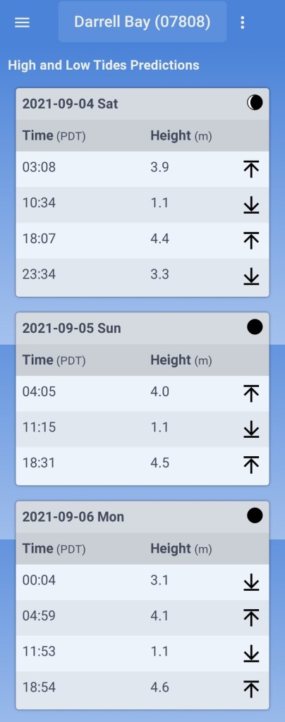
Tides (Darrell Bay)
Saturday, September 4
•0308 High 3.9 m
•1034 Low 1.1 m
•1807 High 4.4 m
•2334 Low 3.3 m
Sunday, September 5
•0405 High 4.0 m
•1115 Low 1.1 m
•1831 High 4.5 m
Monday, September 6
•0004 Low 3.1 m
•0459 High 4.1 m
•1153 Low 1.1 m
•1854 High 4.6 m
Wind
•Forecast: see Windy App for real-time
September 4
Morning (Horseshoe Bay)
•West-northerly to west-southerly (WNW to W to WSW) 2 kt (7-9 kt wind gusts)
Afternoon (Zorro Bay)
•West-northerly to southwesterly (WNW to SW to SWS) 1-2 kt (12-14 kt wind gusts)
Evening (Squamish)
•Southeasterly to northwesterly (SE to W to E to NW) 1-2 kt (15-16 kt wind gusts)
Daylight: 06:33 – 19:48
Civil Twilight: 06:00 – 06:30, 19:48 – 20:21
Nautical Twilight: 05:19 – 06:00, 20:21 -21:01
Paddle Distance ~90 km
Paddle Time ~17 hrs
Personal Info
TRAVELLERS: 2 (Mon Jef Peeters, Trevor Mazurek)
VEHICLE: n/a
PHONE: xxx-xxx-xxxx, xxx-xxx-xxxx
Itemized Itinerary
September 4, 2021 (Day 1)
0600 🚐 ↗️ Home
0620 🚐 ↔️ 🚗
0630 🚗 ↗️ Horseshoe Bay
0645 🚗 ↘️ Horseshoe Bay
0700 🏄🏽♂️ ↗️ Horseshoe Bay (6 km)
0730 🏄🏽♂️ ↔️ Finisterre Island (8-9 km)
0900 🏄🏽♂️ ↔️ Pam Rocks (Christie Islet) (4 km)
0945 🏄🏽♂️ ↔️ Anvil Island (9.5 km)
1115 🏄🏽♂️ ↘️ Zorro Bay Ts’itpsm
1145 🥘 ⏸ Zorro Bay
1215 🏄🏽♂️ ↗️ Zorro Bay (6 km)
1315 🏄🏽♂️ ↔️ Watts Point (4 km)
1400 🏄🏽♂️ ↘️ Tantalus Landing Sxwan’shnm
1500 ⛺ ⏸ Tantalus Landing
1630 🏄🏽♂️ ↗️ Tantalus Landing (6 km)
1730 🏄🏽♂️ ↘️ Squamish Xwu’nekw
1750 🍻 ⏸ Squamish
1920 🏄🏽♂️ ↗️ Squamish (6 km)
2020 🏄🏽♂️ ↘️ Tantalus Landing
(~49 km)
September 5, 2021 (Day 2)
0700 🏄🏽♂️ ↗️ Tantalus Landing (9.75 km)
0845 🏄🏽♂️ ↔️ Zorro Bay Ts’itpsm (4.5 km)
0945 🏄🏽♂️ ↘️ Islet View Marine Recreation Site
1015 🥘 ⏸ Islet View
1045 🏄🏽♂️ ↗️ Islet View (11.5 km)
1315 🏄🏽♂️ ↘️ Ramillies Channel MRS
1345 ⛺ ⏸ Ramillies Channel
(~26 km)
[Christie Islet/Pam Rocks – Round Trip ~10 km]
September 6, 2021 (Day 3)
0700 🏄🏽♂️ ↗️ Ramillies Channel (7.5 km)
0815 🏄🏽♂️ ↔️ Halkett Point (3 km)
0845 🏄🏽♂️ ↔️ Finisterre Island (6 km)
1000 🏄🏽♂️ ↘️ Horseshoe Bay
1045 🚗 ↗️ Horseshoe Bay
1105 🚗 ↔️ 🚐
1125 🚐 ↗️ Home
1155 🚐 ↘️ Home
What About the Weather?
Despite all the planning, preparation, and ideal weather we had leading up to the Labour Day weekend, the weather decided not to cooperate in true Murphy’s Law fashion. There was rain in the forecast that shifted its arrival from Monday to Sunday to Saturday. The change in weather front brought a shift in wind direction, which now meant that we would be leaving on Saturday with a northerly headwind rather than the anticipated southerly tailwind. Below are screenshots of the forecast from Windy.com for the various areas we would be in throughout the first day.

It was going to be a wet paddle at some point. And possibly a windy one.
Timing the Tides
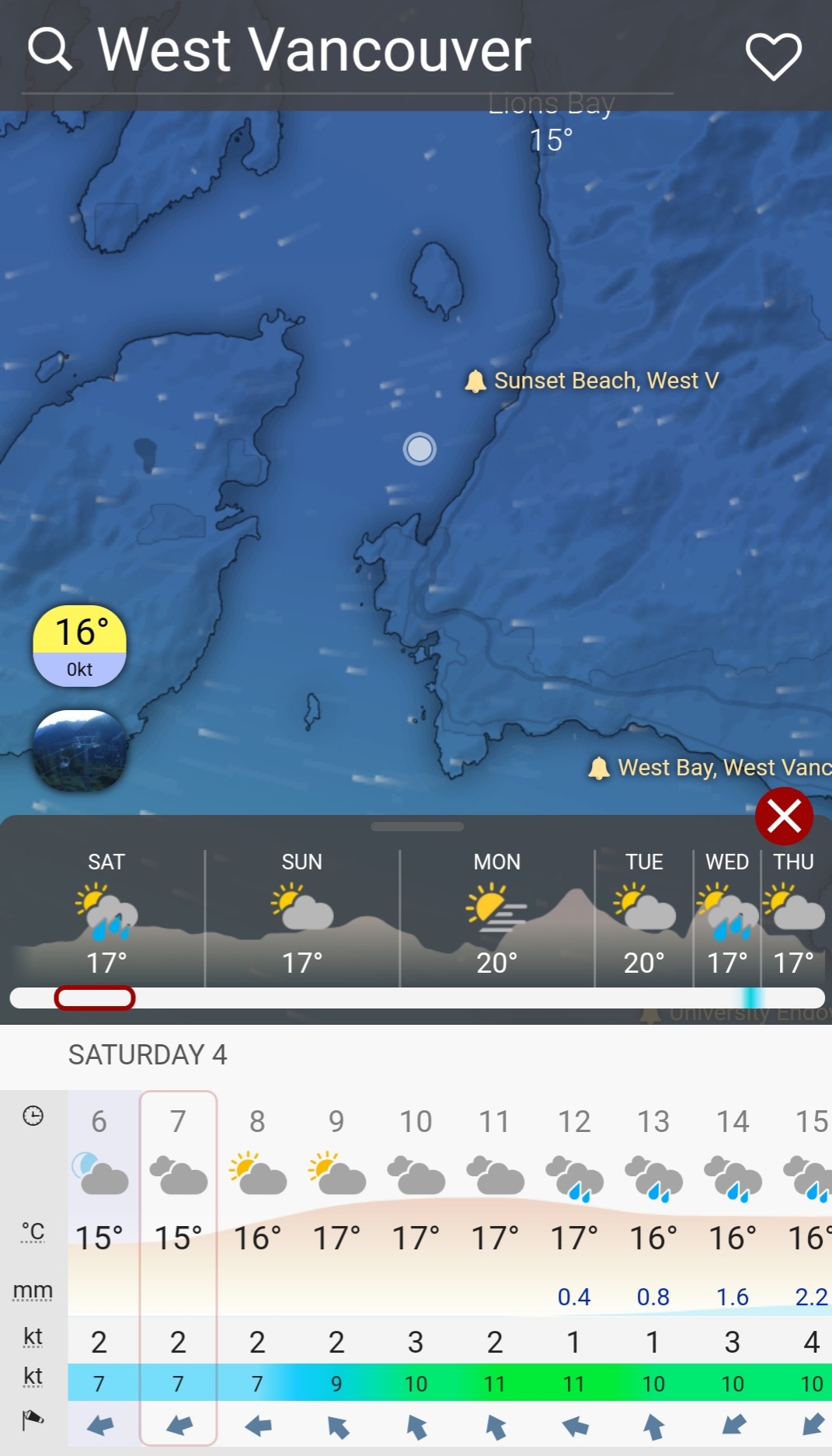
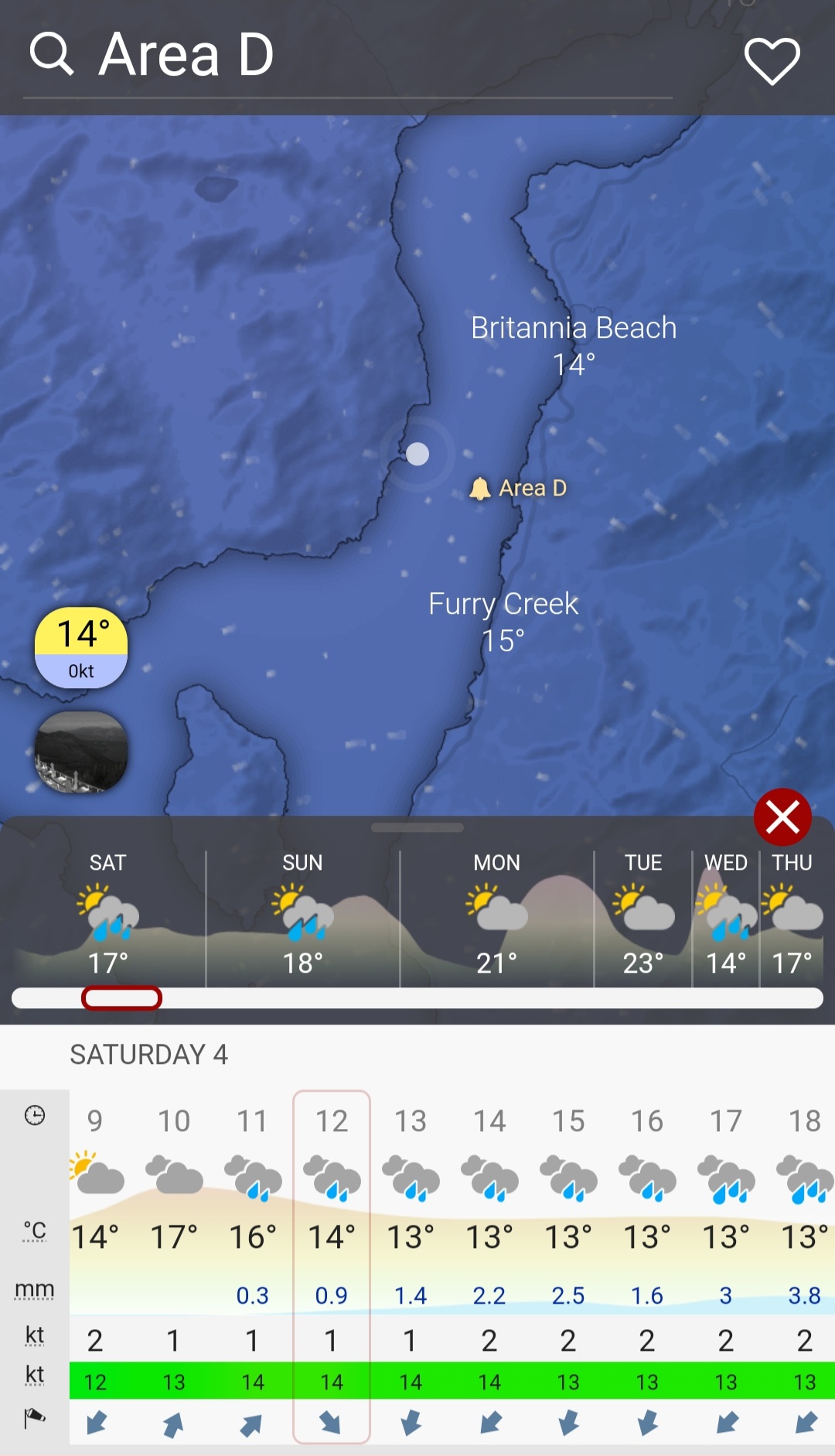
This time, I was again sure to have the tides on hand and gave them more consideration in advance of my trip. The challenging thing about tides with a long day of paddling is even if you know what they are, you are limited in your ability to accommodate them. There are only so many hours in the day to paddle. Below is a graph of the tide prediction for Darrell Bay from the Water-Level App.

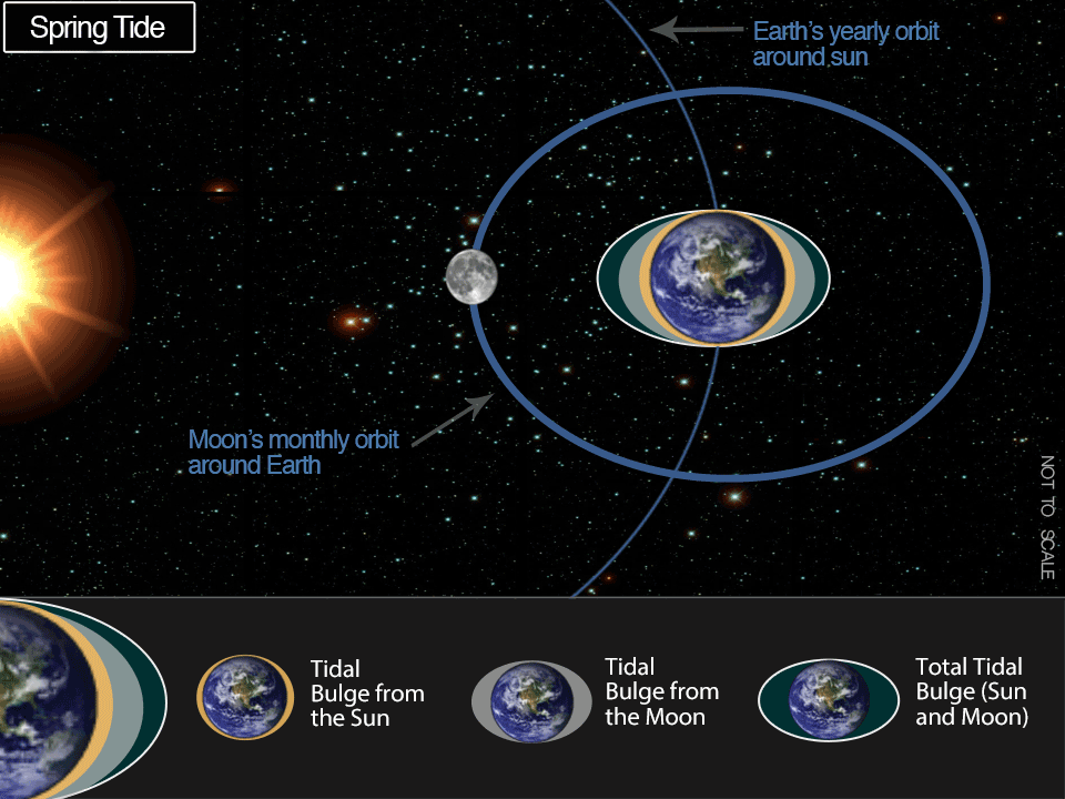
A few days before our trip, while checking out some of the campsite pictures on the BC Marine Trails map webpage, I noticed a warning to watch out for spring tides (or “King Tides”) for the Ramillies Channel Marine Recreation Site (ínaḵa Lhaxwm). The beach is prone to flood under these conditions. I wasn’t specifically aware of the pending spring tide. I looked it up and found out it was going to be Monday, September 6. While I was aware that the tide would be high over our trip, I didn’t realize that we were on the brink of a spring tide. Now, I would be sure to pay extra attention to the high water marks for all our overnight stays and make sure that our gear was well above the tide line. The image below from the USA’s National Oceanic and Atmospheric Administration website displays how the gravitational forces of the Sun and Moon work together to create spring and neap tides.
Guesstimations
And for the mathematically anxious, here is the argument for the practical application of mathematics. It never dawned on me before, but after my experience crossing the Queen Charlotte Channel en route to Bowen Island (Nex̱wlélex̱m) from the southern tip of Passage Island (Mi’tlmetle’lte), I made the connection between the tidal graph (see above) and the current. Somewhere between the high and low tide, the maximum flow rate of water must occur. With memories of my high school calculus and university biomechanics classes flashing through my head, I realized that where the slope of the curve is greatest you would have the fastest speed of water movement. I remember my university biomechanics professor, Dr. Sanderson, admonishing the class that the first derivative of displacement (i.e., linear motion) is the velocity (i.e., speed). Though I am sure that he added the caveat that velocity is a vector, in that it has both a magnitude and direction. In the graph above, the speed or rate of change (i.e., the tide) of the water is fastest where the slope of the curve is steepest. To visualize the slope of the graph, imagine drawing a tangent line at a specific point. The slope of that tangent line (i.e., rise over run) reveals the rate of change or the velocity of the movement of the water (and denotes a direction).
A small caveat must be pointed out here. The tide, simply defined, is the vertical motion of the ocean resulting from the gravitational pull of the Sun, Moon, and Earth (yup, the Earth is so massive it affects its own tides). Whereas, the current is the movement of water from place to place (and generally, more on a horizontal level). They are related, in that tide is a major driver of currents, but they are separate phenomena.
So, the speed of water change referenced above is for a vertical change (i.e., tide). But, my observation (and minor epiphany) is the rate of change in tidal water can estimate the current. The current is likely to be fastest where the slope of the curve is steepest (i.e., between the peaks and troughs of high and low tide, respectively). And the beauty of this, or the practical application, is that you can determine where these points are without doing any calculations, just simply by visual inspection. You won’t know the actual speed in terms of a numerical value, but you can see when the velocity, or current, should be close to its maximum (or minimum). On the Water-Level App, you can scroll along the graph line to see the specific data point.
Note, however, that this is only a rough calculation as it fails to consider the other factors that would determine the current. The video below describes how tide, wind, and thermohaline circulation are the main factors that cause ocean currents. In different settings, for example, a narrow passage, as my father-in-law is quick to emphasize, geography affects the currents. And here, you’re better off trusting in the pre-calculated values available from the Government of Canada.
Tide Chart: The Highs and Lows
All that said, the main points of interest to me out on the water were the high and low tides. The fastest currents were likely to be around the mid-point between those times, as we would be paddling in open water settings. I had a digital copy of the table below saved on my phone, just in case there was no cellular service, and planned to bring a paper copy. However, I forgot to print my tide chart beforehand and only realized it in the waning hours of my packing, when the rest of my household was asleep. I would have to do without the paper copy. But that also, unfortunately, meant that I wouldn’t have a paper copy of the ferry schedules on hand. Though, I would be able to check for ferries in real-time through the Marine Radar app.
Our Kit
Initially, I wasn’t going to bring my semi-drysuit, but as the date approached and with the forecast not looking as hospitable as hoped, I started to reconsider. And then, after coming across this article regarding drowning in the Howe Sound (Átl’ḵa7tsem), I decided it was better to prepare for the worst. After reading the article, I looked up the water temperature for Átl’ḵa7tsem (here are two sources: Sea Temperature Info and the Government of Canada) and some information on hypothermia. I came across various tables, like this one, that gives an overview of water temperatures and the anticipated effects from different immersion times and recommendations for what paddling clothing you should wear. With the temperature in Átl’ḵa7tsem around 16-17 degrees Celsius and the chance for a dip off of the board higher with the predicted winds, I reasoned it would be better to be too hot than too cold.
For my Nex̱wlélex̱m (Bowen Island) SUP trip, I created a camping checklist. You can see it here. It is an all-encompassing list for any SUP camping trip that I use as a template I can tailor to the conditions/trip. I forwarded it on to Trevor to help with his packing. He was more organised than me for this trip and forwarded the image below of his packing preparations on Thursday. I only started packing on Friday night but had the buffer from my past paddle packing practice.
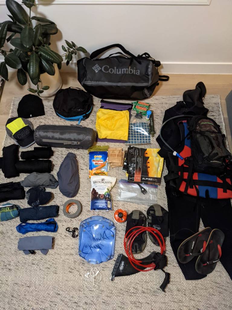
The image below is what I took for this trip, packed and almost ready to go. My paddle and spare paddle are missing from the photo but are with my board bag out of view. And my 20-litre roll-down bags still need to be sealed.

Packing Resources
Two excellent resources that I found helpful to plan and prepare for SUP touring/camping are this four-part SUP Touring series by SUPBoarder. And this video tutorial on Sup Touring: Equipment for Overnight Trips & Expeditions from Norm Hann with Norm Hann Expeditions and James Retty with Escape Route.
Ferdinand’s Sailor Lore
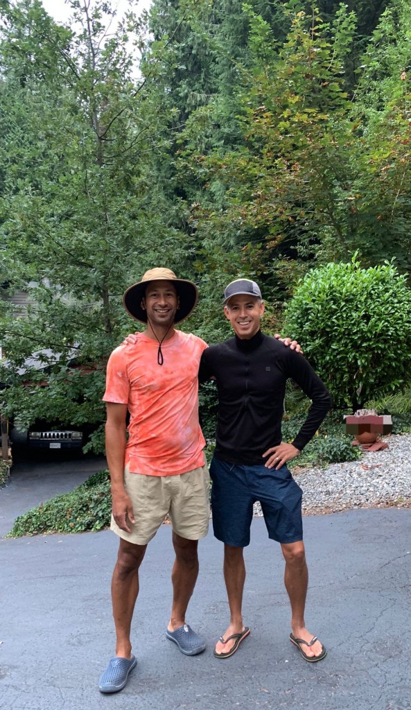
In the morning, Trevor came by to pick me up in his Westfalia, Ferdinand. We loaded up my gear then we were off to North Vancouver to my in-laws’ place. We would drop off Ferdinand there and exchange our gear into my father-in-law, Michael’s, vehicle. He would then drop us off at Horseshoe Bay for our departure. As we made our way across the Lions Gate Bridge, the skies looked spectacular. You could see Mount Baker off in the distance. The skies looked clear to the east, and I was hopeful that the weather forecast would prove to be wrong. Though where we were, the skies were cloudy. Trevor would only recall his sailors’ adage later at the end of our trip.
Red sky at night,
sailors delight.
Red sky in the morning,
sailors take warning.

Here we are ready to depart the Jekyll residence en route to Horseshoe Bay.
Launch Time
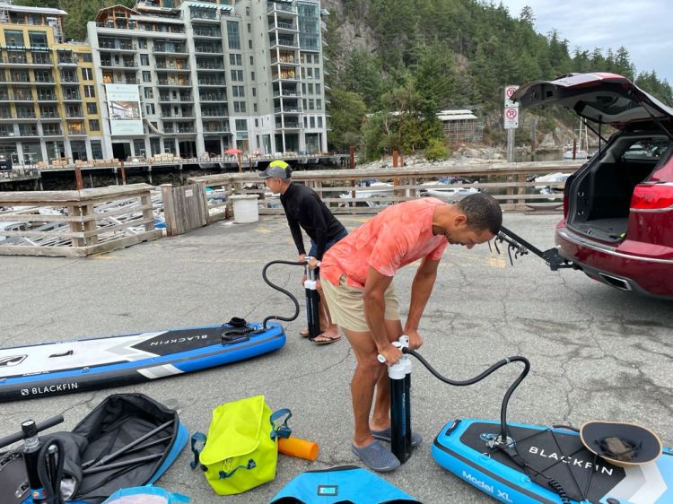
We were able to drive right down to the public dock at Horseshoe Bay to unload our gear. The dock has a three-car limit. But, on a socked-in Saturday morning, there weren’t many other boaters, so there was no risk of surpassing the limit.
It was great to have Michael’s assistance as we had very little distance to portage our gear. Plus, we had the added benefit of using double-chamber pumps to inflate our boards. A luxury I missed on my solo SUP around Nex̱wlélex̱m (Bowen Island). Below are a few images of us getting ready to depart (courtesy of my father-in-law).


It seems I was guilty of some desirability/optimism bias in my planning. For more information on the history of the word bias and the various meanings it has taken on, listen to this podcast, B is for Bias. A fitting podcast for the times.
It took much longer to assemble our gear and get on the water than I had allotted. We were on the water slightly before 08:00. The clips below are our departure from Horseshoe Bay. Don’t worry we were more organized than we sounded. And yes, I am wearing a semi-drysuit in a compromising position with it only half on. But my rationale was that I would need it on eventually when it rained, and I was confident in my ability to not fall into the water at the start of our voyage.
And we are off.
Ferry Tales (Not Fairytales)
We set out to some salty skies, with our first major challenge being navigating the ferry lanes coming out of Horseshoe Bay around Tyee Point. One option was to cross all three ferry lanes simultaneously as we exited the bay heading toward the east shore of the sound. This route required the shortest crossing distance and carried the appeal of finishing all the crossings at once. The risk and challenge was the uncertainty of knowing exactly when the ferry would leave as we would only have a limited window of time to cross and next to no time to adjust our plan once it was in motion. If a ferry was delayed at departure, we would know when it would be leaving and how much time we had to cross.
The photo below, taken by Michael from here on Horseshoe Bay Drive, shows us just exiting Horseshoe Bay. Tyee Point is the leftmost landmass, and Nex̱wlélex̱m (Bowen Island) is the backdrop.

The other option was to cross from Tyee Point toward Nex̱wlélex̱m (Bowen Island). This way would start by crossing the ferry lanes for Vancouver (Horseshoe Bay) to Nanaimo (Departure Bay) as well as Vancouver (Horseshoe Bay) to Bowen Island (Snug Cove). We could then paddle north toward Finisterre Island and then cross the ferry lane for Vancouver (Horseshoe Bay) to Sunshine Coast (Langdale). As it turned out, the Nanaimo ferry arrived as we were assessing our options at Tyee Point, and we had a window of time before the next sailing of the Langdale ferry. We decided to B-line toward Bowyer Island, hugging slightly east to get out of the path of the Langdale ferry. After an expeditious paddle and checking my GPS coordinates to confirm we were out of harm’s way, we settled into a comfortable paddle. The weather was pleasant, and the winds were mild.
Here we are setting out with the Sea to Sky Highway and overcast as a backdrop.

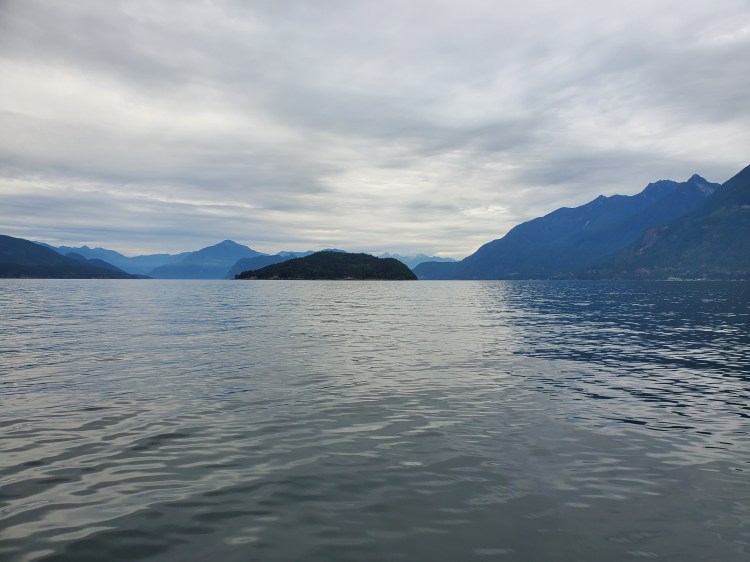
Below is the view back toward Horseshoe Bay, now that we were outside of the ferry lane.

And the view north up Átl’ḵa7tsem (Howe Sound) with Bowyer Island in the centre.
A Welcoming Start
The first part of the trip was quite pleasant. The water was calm, there was minimal wind, and it was fairly warm. Muggy in fact. I was glad that my semi-drysuit was only half on, as with wearing a PFD, I was already feeling warm.

Off toward the west, we could see the north end of Nex̱wlélex̱m (Bowen Island). Hutt Island is the small island to the right of Nex̱wlélex̱m, which is leftmost in the photo below. Cha7élkwnech (Gambier Island) is the rightmost.

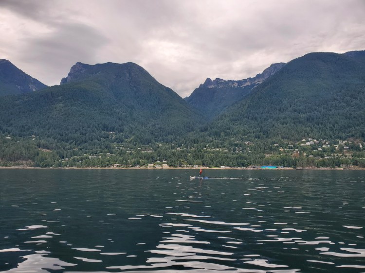
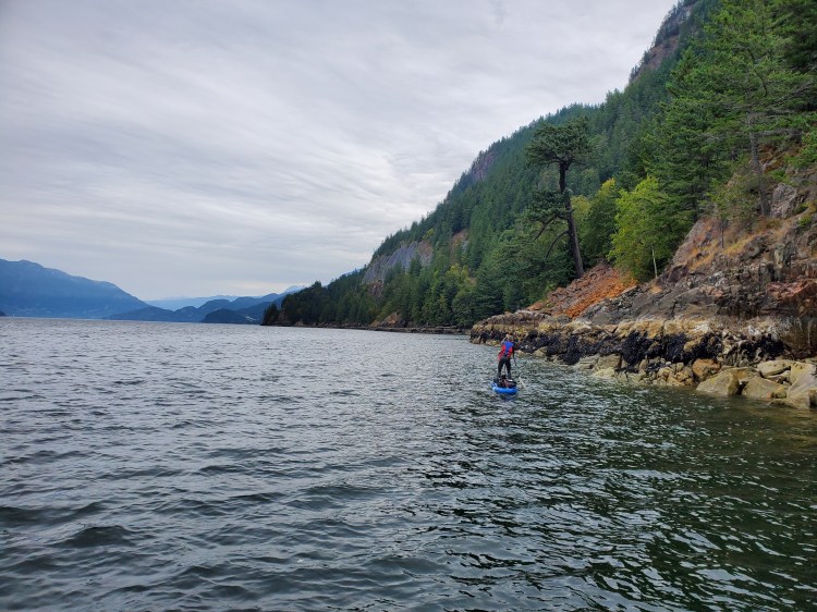
As we made our way more northward, the northerly wind became stronger. We had to decide if we would cross to the west side of the fjord or stay to the east side. My original plan had been to ride the southerly tailwind down the middle of the sound. The northerly headwind was an organization oversight obstacle. We convinced ourselves that we would (possibly) have less headwind on the east side of the sound if we followed the shoreline up along the Sea to Sky Highway. Below is the view of Anvil Island (Lhaxwm) after passing by Bowyer Island.

We also got a good view of Brunswick Beach from the water. I was curious about the beach as it could be a solid downwinding launch/landing site. However, it seems that parking could be the bottleneck on such an adventure. In any case, the geography of the beach lent itself to launches and landings. I catalogued the idea away as a possible future adventure. In the photograph below, Brunswick Mountain is to the left of the valley, behind the visible peak. Mount Harvey is to the right of the valley. The European names of the mountain peaks and the name of Howe Sound stem from the Battle of the Glorious First of June and the associated captains and ships that took part in the battle that was part of the French Revolutionary Wars.
Sea to Sky Waterway
While staying close to the Sea to Sky Highway was less of a novelty experience, it still was a new perspective on the sound. Interestingly, we passed by a couple of intriguing structures along our way, two cabin-like dwellings, as well as a stowed-away canoe buried underneath what appeared to be some landscaping fabric. We concluded that it was someone’s Anvil Island crossing secret stash away. The image below is the first of two covert cabins that we spotted from our mariner vantage point. It is tricky to see, but it is slightly right of the centre of the image and looks like an old-school VW Bus.
The image below is the view out over Archer Point toward Anvil Island.

And a closer look at the first of the mystery cabins. As we approached, we couldn’t tell if it was a bus or a train car. As we got closer, it appeared to be a tarp structure with windows, making it appear like a bus.

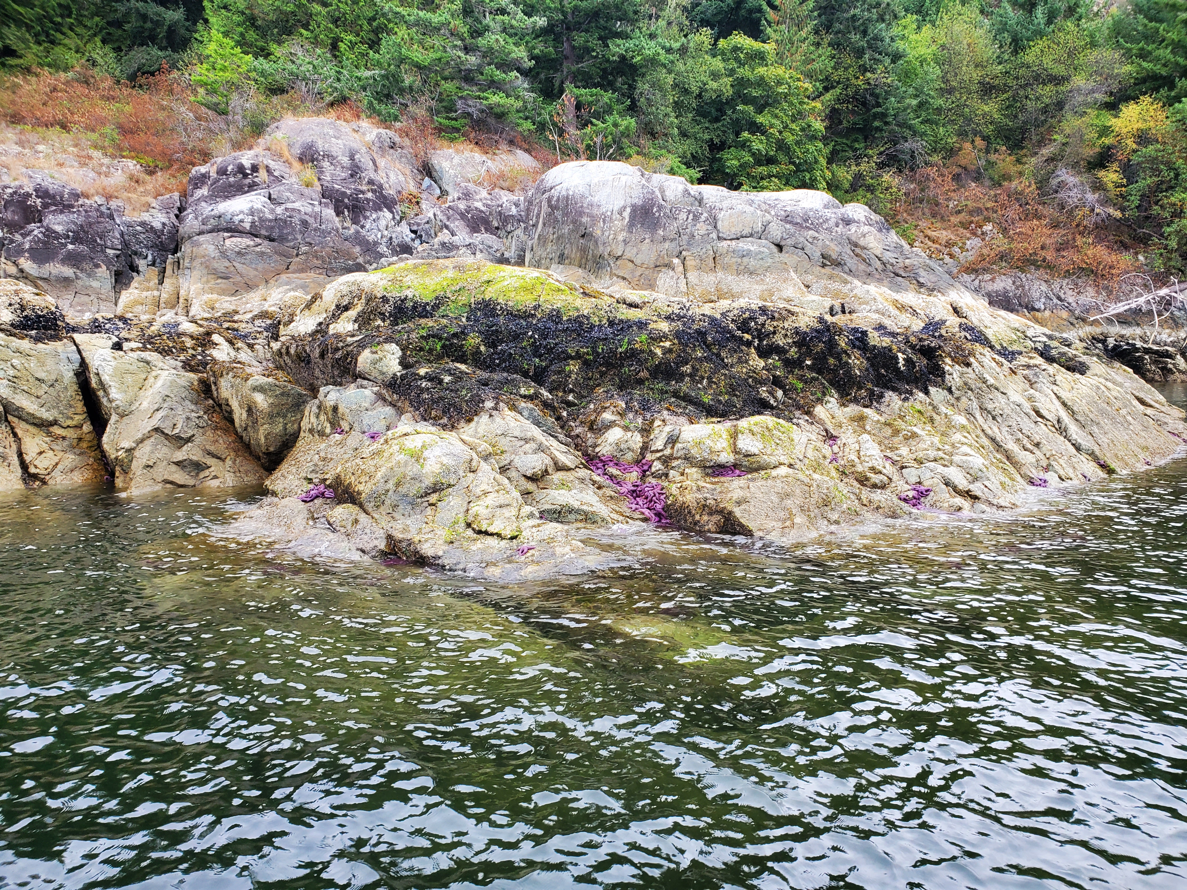
A little way later, we came across a galaxy of sea stars. I had to take some photos for my boys since we had quite the conversation about purple ochre sea stars on our Wildlife Exploration SUP trip on Vancouver Island. Our exchange stems from a book we have, Nuptse and Lhotse Go to the West Coast, where two venturesome cats go on an adventure to return a lost sea star to its home.

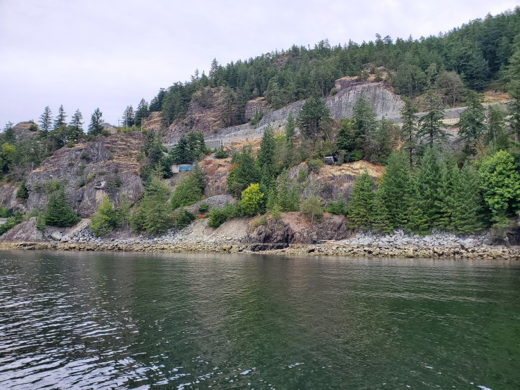
Around this time, Trevor made the heads-up call to get into our rain gear. We did an on the water change in preparation for the approaching precipitation. I also took a moment to marvel at the highway engineering that we are mostly oblivious to as we zoom down the Sea to Sky roadway.

Below is the view as we make our way into Montagu Channel.

I thought the tree in the image below was a worthwhile stand-out compared to his more branched brethren.
We then came across our second curious cabin. This one appeared to be deliberately camouflaged from the water by trees, except for the white window frame. This cabin seems to be close to the railway, and I wondered if it had an associated history or if that was just a coincidence. The slideshow below shows the cabin from our vantage point on the water, and the same photo zoomed in. The log cabin is right of centre in the image and nestled into the shorter trees on the small bluff.


As noon approached, we were getting tired and hungry. Our planned lunch destination of Zorro Bay was proving to be too far to reach at a reasonable time. We would still need to cross the fjord to the western shore and travel over 6 kilometres northward into headwinds. So, we decided to stop at Porteau Cove Provincial Park for lunch. I was somewhat disappointed, as I was looking forward to seeing the other side of the fjord. But it had been years since I had been to Porteau Cove, so that was consoling. I read after our trip that the origin of the name of “Porteau” is from the French porte d’eau, meaning “water’s gate” when translated to English. I grew up speaking French in our household, so it is slightly embarrassing that the connection had not dawned on me until now.
Lunch Time
We landed at the small cove just south of the main camping area. According to the Canadian Geographical Names Database, this cove is Porteau Cove, whereas, on other maps, it is labelled as the larger bay. The tide was low so, after landing, we used some of the shoreline features to suspend paddleboard fins.

The rain was coming down now, so we took shelter under the tree canopy to prepare lunch. Lunch was Caribbean Curry from Nomad Nutrition as a starter with AlpineAire Sweet & Sour Pork as our entrée. We took advantage of the waste management facilities at the park to lighten our load, as we knew the other sites along the BC Marine Trail were less equipped.
With the tide rising, we did need to relocate our boards. Below is the water level on our departure. It was still raining.
The Squamish squamish
We paddled out of Porteau Cove, anticipating headwinds as we rounded the point. We were both pleasantly surprised that the wind wasn’t too strong. We even commented on such. However, the sea gods would soon spite our satisfaction with our good fortune. As we made our way toward the boat ramp and diving area, the weather changed. A rapid buildup of wind and rain forced us onto an un-advancing water treadmill. With white caps forming in the sound, my mind couldn’t help but think of the article I had read about the kayakers running into trouble in these waters. Were we in over our heads? No. We could handle this. We were prepared for our circumstances with appropriate clothing and milder conditions.
There were two boats in the bay. One was a fishing boat with a group of gentlemen that cheered on our bravado. It was shortly afterward that my hat blew off. Fortunately, it had a chin strap so, it only fell to my back. But it was a clear sign that the winds were too strong. As I came to this realization, the other boat, a motorized inflatable that had passed by on our port side, pulled up on my starboard side. They were concerned for our safety, a kind gesture. The young gentlemen piloting the craft asked me my destination. Knowing that our hopes to reach Squamish had been dashed and not wanting to sound like a complete lunatic, I hedge my response. I told him we were attempting to get to Zorro Bay. Crazy, but not as crazy as Tantalus Landing. I then suggested that we were likely to turn back to Ramillies Channel (ínaḵa Lhaxwm). He seemed to confer that was the best option.
Trevor and I discussed our options and concluded that heading to the Ramillies Channel (ínaḵa Lhaxwm) campsite was our best option. I could feel the disappointment of the admission that our hopes of completing the trip on this attempt were over.
Know When to Fold Them
As I have written in my Rules of Engagement post, quitting is an option. Here was a case of putting my paddling principles into practice. There will be another time to complete this trip in the future to satisfy my ego.
Audible Around Anvil
The remaining question was how to get to the Ramillies Channel (ínaḵa Lhaxwm) campsite. Should we cross the north or south side of Anvil Island? A crossing at the north end meant an almost perpendicular path across the wind and chop. If we crossed at the south end, we could ride downwind and then cross the first section toward Cha7élkwnech (Gambier Island) in the leeward waters of Anvil Island. From memory, I was picturing the campsite more toward the north end of Ramillies Channel (see here for the geographical boundaries of the channel). With that assumption, I was worried that if we headed to the south side of Anvil Island, we would have to backtrack up the waterway against a headwind.
As we made our way toward Anvil Island, the cross chop proved formidable, and the ease and allure of downwinding were too enticing. We changed course and set our sights on the peninsula at the southeast aspect of Anvil Island.
It was a welcomed break and fun to change direction and ride the bumps downwind. We rode the bumps into the rising tide en route to the south side of Anvil Island. Once there, we paddled into the wind-sheltered waters making our way toward Irby Point. It was just after Irby Point that we encountered two hawks resting perched in a tree. I took it as a good omen for our route.
And it turned out to be. There was next to no wind coming through Ramillies Channel (ínaḵa Lhaxwm). In hindsight, this makes sense, given the bend that occurs in Átl’ḵa7tsem (Howe Sound) near the Defence Islands (Kwum Kwum). And, after checking my map, I realized that the Ramillies Channel Marine Recreation Site was much farther south than I had remembered and was essentially straight in front of us after we rounded Irby Point.
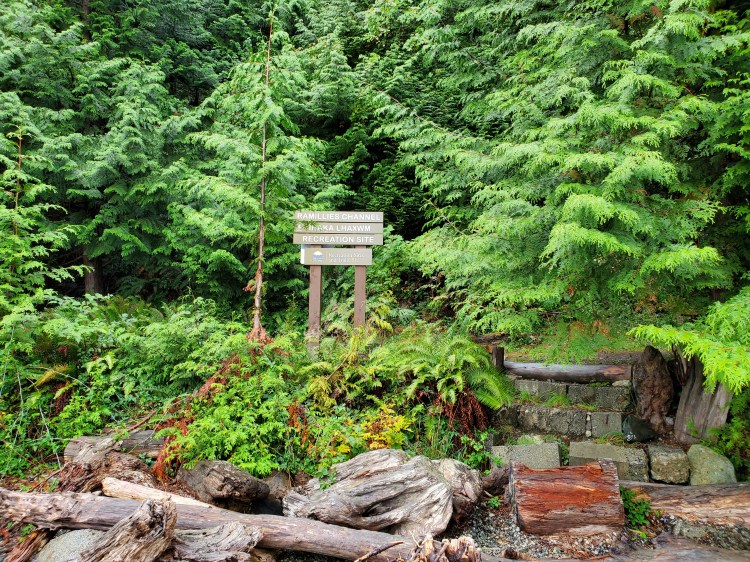
Ramillies Channel Rerouting
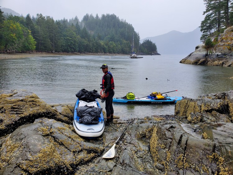
We landed at the Ramillies Channel (ínaḵa Lhaxwm) campsite under socked-in skies. But the site’s natural beauty was still evident. The site is well-marked with signage from the water and also has a full-scale map of the marine trail onshore. The photos below are from Saturday morning hence the better natural light.

The image below was the view of Anvil Island when we landed at the Ramillies Channel (ínaḵa Lhaxwm) campsite.
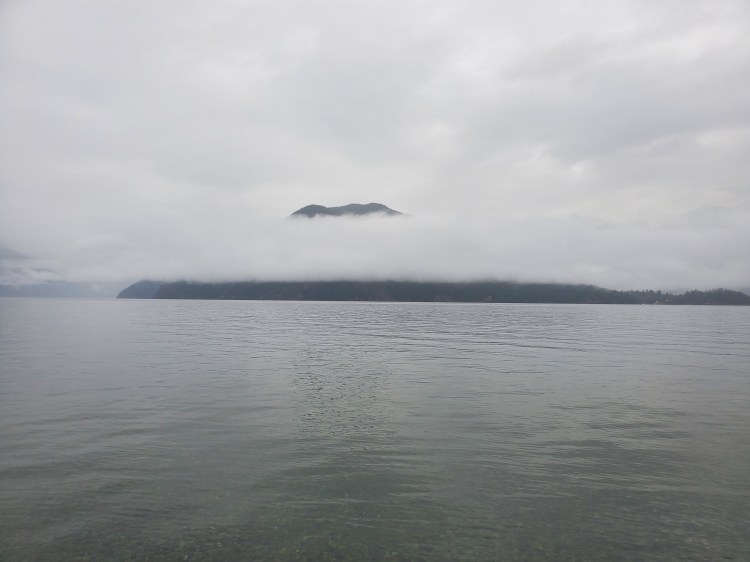
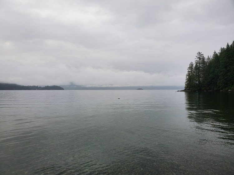
And below is the view southward back toward Vancouver. Christie Islet is a small piece of land just right from the centre of the photo.
Camp Mazu-pee
We set up camp on the tent clearing that looked like it would remain mostly dry and with the best configuration for setting up a tarp. Thankfully, Trevor had recently upped his tarp game on some recent trips, so we were in fine form. Below is a shot of Camp Mazurek/Peeters. The tree canopy provided some excellent rain shelter for our dinner, which we ate standing beneath it.

After a meal of Nomad Nutrition Irish Shephard’s Pie, which for the record is my favourite meal by them thus far, and AlpineAire Kung Pao Chicken washed down with some beer, we were ready to call it a night. We fell asleep to the pitter-patter of rain as we slowly slipped down the gradual slope in our sleep bags.
Below is a virtual recreation of the route we took, created using Google Maps, Google Earth Studio, and OpenShot Video Editor.
And here is the Google Map version of our paddle route for day one.
Stay tuned for day two’s adventure…

5 thoughts on “SUP’in the Sound”