
Saturday, July 24, 12021 HE
Shhh….hush, this one is an insider secret.
A lot of thought and preparation went into this trip. A bit ironic because it was only one night, but it is something that I have wanted to do for a while, with a long-term goal of doing a multi-day trip (e.g., the Sea to Sky Marine Trail).
I originally planned to do a trip similar to this one at the end of May. At the time I planned to go to the Ramillies Channel Marine Recreation Site on Cha7élkwnech (Gambier Island).
Note, that I will use both the Western and Indigenous names throughout the post as I am more familiar with the Western names but acknowledge the indigenous history of the territory.
Selecting the Ramillies Channel site came after lots of consideration between doing a solo trip without a pick-up or drop-off or with assistance for pick-up/drop-off. In the former case, I planned to leave from Spanish Banks so that I would be able to drop myself off with Evo Car Share. For the latter, the plan would be to depart from the Horseshoe Bay public dock.
Initially, I had looked into Halkett Bay Marine Provincial Park on Gambier Island as it was the closest legal campsite. But after reading that campfires were not permitted inside the park (see the “Know Before You Go” section) I needed another destination. To me, camping means a campfire. Especially, at the end of what was supposed to be a long spring paddle. A campfire at the end of that was a necessity in my eyes (remember the initial goal was to do this in May!). So the next option was the Ramillies Channel Marine Recreation Site. Which did not have a campfire restriction (at the time) as far as I could tell. And as luck would have it, in the lead-up to my May trip I was sent this link to a virtual tour of the Ramillies site in the BC Marine Trails newsletter. I took it as a sign from the sea gods that this was my destination. Ramillies Channel from my research was the closest legal campsite accessible by the water where you could legally have a campfire.
So in the lead-up to the last weekend in May, the weather was looking good, I had my kit in order, and a green light from my wife. But a few days out two things came up that would change my plans. I was going to be doing a solo trip, which was already a bit nerve-racking. But as the date approached I started to reevaluate my emergency communication system, especially after my recent kayak encounter. I was for sure going to pack a cell phone. But after rechecking the Telus cellphone reception area and speaking with my father-in-law, who as an avid sailor confirmed that there would be no cellphone reception on the northeast coast of Gambier Island, I decided I wanted some form of backup communication. Or perhaps better stated a primary communication device. I recently received my VHF radio certification but I had yet to purchase a radio. I bought one impromptu online, the ICOM IC-M25 11. So that was the first hang-up.
The other thing that came up was that my wife was scheduled to receive the second dose of her severe acute respiratory syndrome coronavirus 2 (SARS-CoV-2) vaccine on the Friday before. With reports of the side effects of the second dose of the mRNA platform vaccines being worse than the first, we decided to err on the side of caution and not have me galavant off into the sunny waters as she warded off the ill-effects a functioning psycho-neuro-immunological system response.
So in the extra planning time that I now had available, I decided to look at some alternative route options and revisit the Ferry schedule. It turns out that a suitable weekend for weather and family would not present itself for nearly two months.
With my original route, departing from the Horseshoe Bay public dock, I would be crossing three ferry lines, two as I crossed from Tyee Point in West Vancouver to Finisterre Island off of Nex̱wlélex̱m (Bowen Island), and one more as I crossed from Finisterre Island to Gambier Island. Some options to avoid the ferry traffic would be to depart from Ansell Point, Sunset Marina, or the Lions Bay area. Initially, I had not considered those options as my original plan was to leave from Spanish Banks. But, I decided against that for my first overnight SUP tour since I planned to only stay for one night, and it would be a really long trip to get to Gambier from Spanish Banks. If I was going to be dropped off, the other launch spots became a lot more convenient.
So I set my sights on Gambier Island with a departure from Horseshoe Bay (or the surrounding area). This was after my research into Bowen Island seemed to suggest that camping was not permitted there (see my addendum). Bowen seemed like an obvious destination since it is the closest largest, sparsely inhabited island to Vancouver. But no camping, let alone campfires took Bowen off of my candidacy list.
But then a third wrench entered the delayed plans. Enter the province-wide fire ban.
I started to reconsider my original plan of leaving from Spanish Banks and camping on Bowen Island. When I first looked into this I came across several posts that said that camping on Bowen Island was prohibited. But after some more searching, I found that the legality of camping on Bowen Island seems to be a little bit contentious. The best account I could find online is this one that can be summarized as while camping is not illegal on Bowen Island it is definitely not encouraged by the inhabitants. I had previously seen this outdated BC Parks Master Plan document for Apodaca Provincial Park that mentions a goal of developing walk-in campsites in the park. The document is from 1984 and as far as I can tell no progress has been made toward that end. The gears started to turn for me that if I wasn’t going to be doing a fire I would be leaving a minimal trace. Plus a lite fire on the west coast of Bowen Island in a forested area would not only be stupid (in fairness I was first considering this before our heatwave/mini-drought), it would be less than conspicuous.
With fires banned everywhere, the other closer locations became more appealing. Theoretically, places in səl̓ilw̓ət (Burrard Inlet/Indian Arm) which are also under fire restriction normally were now looking like good options. But I had done a kayak trip years ago up səl̓ilw̓ət so I wanted something new. Plus now I had my heart set on the Átl’ḵa7tsem (Howe Sound).
And then another sign from the Sea Gods for this iteration of the trip. From looking at maps I had wondered whether or not camping (cough squatting) on Hutt Island, a small island off of Bowen Island’s northwestern shoulder, would be possible. I tried to check out the terrain with Google Maps and Google Earth. Previously I have been burned by failing to consider elevation changes from just using two-dimensional maps (see here for Boundary Bay: Kwomais Point to Mud Bay and more recently here for Alouette Lake). But I didn’t want to take a chance on this one, as paddling halfway around Bowen Island only to be S-O-L for a place to stay would be unpleasant, to say the least. In non-pandemic times I might be more apt to risk it and then hope to find accommodations elsewhere on Bowen. But not in 12021 HE.
But that is when the Sea Gods turned up this gem of a blog post on my screen, Hutt Island – A Close Shave when I was searching for information on circumnavigating Bowen Island. I didn’t even have Little Flower Islet (aka. Flower Island) on my radar, but now I did. And the more I looked into it the better it looked. Specifically, the map that my BC Marine Trails membership provides access to gave me details to inspired my confidence in the site along with the inspiration from the blog post.
I had previously done a recon trip with a loaded board and felt comfortable with the gear aspect of the trip, provided the conditions were similar. Camping, check. Solo-camping? Well, that would be new, but I figured it couldn’t be that much different from all the solo-SUPing I have been doing of late.
My last-minute additions to my kit were that I picked up a copy of the Sea to Sky Marine Trail map from MEC. While I was there I also spied some hammock-style tents with the thought that they could be an easier option for setup and takedown for future multi-day touring trips. But let’s not get ahead of ourselves here. First I needed this trip to be a success and pleasurable.
I committed to this weekend despite not having a paddling partner. Given that this one-night trip had already taken more than two months to come to fruition I wasn’t about to pass up the great weather and favourable work/family schedule. A screenshot of the forecast from Windy.com is below. Light winds and clear skies. Though I was well aware that the hotter temperatures would make for stronger anabatic winds at the mouth of Átl’ḵa7tsem. And the trouble with doing a circumnavigation is that at some point your tailwind is a headwind or vice versa. Based on the weather leading up to the weekend my plan was to most likely circumnavigate the island counter-clockwise, but I would make the call depending on the conditions.
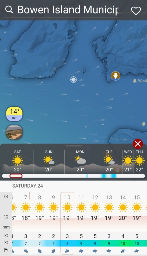
I also made sure to have the tides on hand, both to have a sense of the currents as well as wear to stow my gear on arrival at Little Flower Islet. At low tide, it would be connected to Hutt Island and the BC Marine Trails Map suggested landing on the southeastern shore of the isthmus or tombolo. Below are the tide predictions from the Water-Level App for Point Atkinson and Gibsons.


I set up a float plan including an itinerary. I made the itemized itinerary quite detailed both for myself to get a gauge of how long each leg would take as well as for my wife so that she would have some general waypoints for me in case something should go wrong. Plan for the worst and hope for the best.
SUP FLOAT PLAN: Spanish Banks to Bowen Island Circumnavigation
DATE: Saturday July 24, 2021
ROUTE: Spanish Banks to Bowen Island (Apodaca Park)
VESSEL: Teal Blackfin Model XL iSUP
EST. DEP. From Spanish Banks: 0530
EST. ARR. @ Hutt Island: 1320
EST. DEP. From Hutt Island: 0630
EST. ARR. @ Spanish Banks: 1320
Details:
Tides (Point Atkinson)
July 24
•0023 Low 3.5 m
•0501 High 4.3 m
•1230 Low 0.3 m
•2003 High 4.7 m
July25
•0115 Low 3.4 m
•0556 High 4.3 m
•1314 Low 0.4 m
•2040 High 4.7 m
Wind
Forecast: see Windy App
July 24
Morning
•Southeasterly (SE) 2-3 kt (7 kt wind gusts)
Afternoon
•Westerly to Southwesterly (W, SW) 3-5 kt (9-10 kt wind gusts)
Evening
•Westerly to Southwesterly (W, SW) 3-5 kt (9-10 kt wind gusts)
Daylight: 0534 – 2102 hours
Civil Twilight: 0455 – 0534; 2102 – 2141
Nautical Twilight: 0402 – 0455, 2141 -2234
Paddle Distance: ~59 km
Paddle Time: ~19 hrs
Personal Info
TRAVELLERS: 1 (Mon Jef Peeters)
VEHICLE: Evo Car Share (one-way rental)
PHONE: xxx-xxx-xxxx
Itemized Itinerary
July 24, 2021
05:00 🚗 ↗️ Home
05:15 🚗 ↘️ Spanish Banks East Concession
05:30 🏄🏽♂️ ↗️ Span. Banks East Concession (7 km)
07:00 🏄🏽♂️ ↘️ Point Atkinson
07:15 🏄🏽♂️ ↗️ Point Atkinson (3.5 km)
08:00 🏄🏽♂️ ↘️ Passage Island
08:15 🏄🏽♂️ ↗️ Passage Island (3.3 km)
09:00 🏄🏽♂️ ↘️ Apodaca Park, Bowen Island
09:10 🚶🏾♂️at Apodaca Park
09:45 🏄🏽♂️ ↗️ Apodaca Park (4.6 km Snug Cove)
10:45 🏄🏽♂️ ↔️ Snug Cove
11:05-11:25 🏄🏽♂️ ↘️ CatesBeach/Hood Point (5.5-6.1 km)
11:15-11:35 🥘 at Hood Point (Cates Beach?)
13:30 🏄🏽♂️ ↗️ CatesBeach/Hood Point (5.2 – 5.8 km)
14:30 🏄🏽♂️ ↘️ Hutt Island (total ~26 km)
16:00 🏄🏽♂️ ↗️ Hutt Island for Circumnavigation
16:45 🏄🏽♂️ ↘️ Hutt Island
[Hutt Island Circumnavigation: 2.5 km]
July 25, 2021
06:00 🏄🏽♂️ ↗️ Hutt Island (4.4 km)
06:50 🏄🏽♂️ ↘️ Crayola Beach
07:00 🏄🏽♂️ ↗️ Crayola Beach (4.7 km)
08:15 🏄🏽♂️ ↘️ Cape Roger Curtis
08:25 🚶🏾♂️at Cape Roger Curtis
08:55 🏄🏽♂️ ↗️ Cape Roger Curtis (8.4 km)
10:40 🏄🏽♂️ ↘️ Apodaca Cove
10:50 🏄🏽♂️ ↗️ Apodaca Cove (3.3 km)
11:35 🏄🏽♂️ ↘️ Passage Island
11:45 🥘 at Passage Island
12:45 🏄🏽♂️ ↗️ Passage Island (3.5 km)
13:30 🏄🏽♂️ ↘️ Point Atkinson
13:35 🏄🏽♂️ ↗️ Point Atkinson (7 km)
15:15 🏄🏽♂️ ↘️ Spanish Banks
15:45 🚗 ↗️ Home
16:05 🚗 ↘️ Home (total ~31 km)
I had some technical difficulties at the end of my paddle getting my GPS data. So I resorted to using Google Maps and Google Earth Studio to re-create a virtual tour of my SUP route. Below is the overview of Day 1 in Google Earth Studio.
Below is the Google Map version of my paddle.
I also had a packing list that I had created to use as a checklist to ensure that I did not forget anything. I have included it here as a reference tool. It is an all-encompassing list for any SUP camping trip that I use as a template that I can then tailor to the conditions. For this trip, I brought all the items with an asterisk.
SUP Camping Checklist
•PFD* or Inflatable PFD
•Leash
•Coiled* [Blackfin leash]
•Straight
•Spare Fin(s)*
Spare Paddle*
Portable Pump*
Patch Kit*
Rope*
Tape
•Electrical Tape*
•Duct tape (tight roll)*
Multi-tool*
Blunt Tip Paddling Knife*
Knife*
Folding Saw
Axe
Clothing
•Paddling Gloves
•Booties
•Down Jacket hoodie*
•Fleece Hoodie
•Rain Jacket*
•Dry-suit (or Wet-suit) [Kokatat Endurance Semi Dry Suit]
•Board Shorts*
•T-shirt*
•Tank Top
•Long Sleeve* or Long Sleeve Base Layer
•Long Pants Base*
•Cap*
•Neoprene Beanie
•Wool toque
Toiletries
•Toothbrush*
•Toothpaste*
•Floss*
•Contacts*
•Contact solution*
•Toilet paper*
•Wet wipes
Sunscreen*
Sunglasses*
Glasses*
Waterproof bags
•Cellphone Lanyard
•Electronics Bag*
•Roll down
•5 L*
•10 L*
•20 L*
•20 L*
•Duffle-style Deck Bag – 30 L*
•Dry-Liner Bag – x 2*
•Waist Pack*
Towel*
Wet clothes bag
Survival kit/First Aid Kit*
Food
•Water
•Water filtration
•QuenchSea
•Grayl Geopress*
•Hydration Pack*
•Water container – hang sack*
•Dehydrated Meals*
•Snacks
•Bars*
•Nuts*
•Trail-mix*
•Dried fruit*
Sleeping System
•Tent*
•Tarp
•Sleeping bag/liner*
•Air mattress*
•Travel Pillow*
Solar Lantern*
Headlamp (waterproof)*
MSR burner*
Lighter*
Fuel*
Pots/Utensils*
Wash Basin*
Camp Soap*
Wash Rag
Drying cloth*
Garbage bags
•Small*
•Medium
Seat cushion
Navigation
•Map*
•Compass*
•GPS (phone)*
Communication
•Marine VHF Radio*
•Satellite Communication Device
•Cellphone*
Snorkel Mask
Snorkel fins
Electronics
•e-Reader*
•Reading light*
•Extra batteries*
•Cellphone*
•Cables*
•Camera phone
•Tripod
•Power Pack/Solar Charger*
That list looks like a lot now that I see it written out. But the image below shows what I took for this trip, all laid out ready to be packed.

I found two great resources that I found helpful in planning/preparing for this trip. The first was this four-part SUP Touring series by SUPBoarder. The second was this video tutorial on Sup Touring: Equipment for Overnight Trips & Expeditions from Norm Hann with Norm Hann Expeditions and James Retty with Escape Route.
Once all-packed, my gear was all that is in the image below. I also had a 2-litre hydration bladder backpack (see the picture above) and PFD that I would be wearing. In the end, I decided not to weigh myself down with the hydration backpack and just fastened it on top of my dry bags.

After an early morning Evo Car Share ride down to Spanish Banks East Concession, I was ready to get my kit in order. I had a single-chamber pump that I used to inflate my board. Wil had given it to me after it arrived with a cracked pressure gauge, and he was warrantied a replacement pump. It took a bit longer than my regular double-chamber pump but eventually did the job. In the future, I may look into getting a better pump for touring trips.

And here I am ready to embark. Well, almost ready I still needed to attach my fin. I figured it would be better to get my board into the water before putting on the fin with all that extra weight on board. The nice thing with the 2020 and newer Blackfin models is that they have flip-lock fins. They are super easy to attach and detach, which was convenient for this trip. I decided to use the centre fin and not the side thruster fins. I do think my tracking suffered, and that wasn’t offset by reduced drag as I had hoped. But, it was quick and easy for landing and launching.

And the weather was spectacular setting out. Clear skies and calm waters as I made my way across səl̓ilw̓ət (Burrard Inlet). Before leaving, I did check for large-vessel traffic on the Marine Traffic site. The coast was clear.
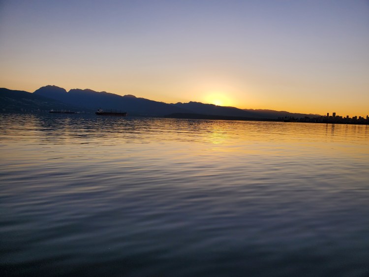
Below is the view northeast, with the sun rising over some of the North Shore Mountains.
And the view west out towards Point Grey. Very glassy, though I knew the conditions weren’t going to stay this way.

I made my way out past some of the moored freighters in səl̓ilw̓ət (Burrard Inlet). I could see the eastern side of Bowen Island far-off in the distance. A straight line would be faster, but I would be crossing a deep-sea transit route, so I wanted to cross perpendicularly to minimize my time in the pathway. I did another visual check for vessels and a digital check on the Marine Traffic site. Still clear, so I made my way across the inlet, quickening my pace.
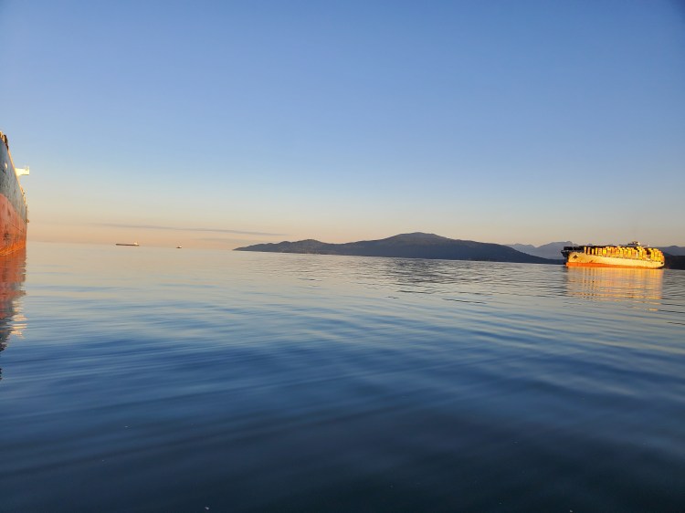
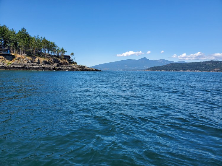
Here is the view from a bit further out in the inlet with my first three destinations on site. The Point Atkinson Lighthouse is on the right, Mi’tlmetle’lte (Passage Island) is in the centre foreground, and Bowen Island is behind it. Already the water is getting more textured as the day goes on, and I am more exposed to the open water.
On the other side of the inlet, the waters are calmer again.
The sun was now out in full view and showing off its true star nature.

I had planned to land at Point Atkinson and get off of my board to stretch my legs. But when I arrived I felt pretty good. Plus, now that I was there finding a suitable rock ledge to dock at seemed more daunting. I knelt on my board for a snack and some water. And it proved to be a fortuitous decision. In the quiet, I heard a blow behind me and turned around to see the short dorsal fin of a cetacean as it dove into the water. It did a few more and I scrambled to get my camera out. I just caught it briefly before it dove for a more prolonged period. Later it would surface again but after I had already put my camera away in preparation for the next leg of my voyage. After a little research after getting home I figure this was a harbour porpoise.
Next stop? Passage Island.
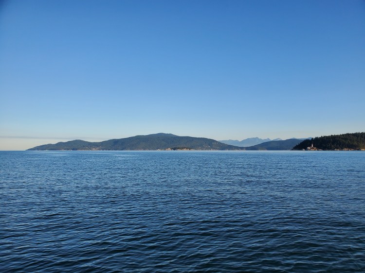
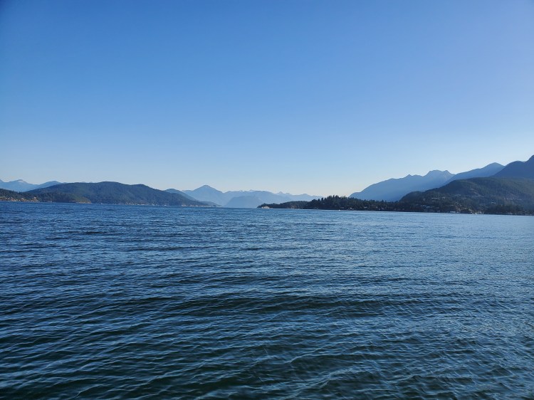
Below is the view northward into the sound. Horseshoe Bay is on the right with Whytecliff Point/Park and Whyte Islet visible. Gambier Island and the northern tip of Passage Island are on the left.
I made it to the east side of Passage Island and again felt good, so I decided to push on without landing. I wasn’t sure if I could pass in between the two sections of the island, so not wanting to backtrack, I played it safe and rounded the southern tip.
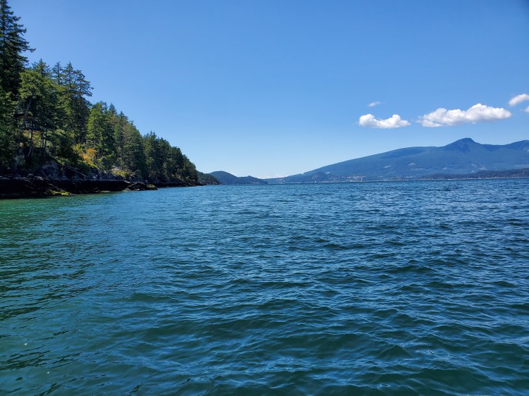
I was then into the Queen Charlotte Channel on the west side of Passage Island. The waters here changed again, and in one section, I almost came off my board with the mixing currents. With Bowyer Island off in the distance, I couldn’t resist taking a quick photo. Bowyer was my first island circumnavigation, so it was a nostalgic moment as I set off on this quest.

Unfortunately, my timing resulted in me crossing the channel at essentially the maximum ebbing current. It was a challenge to get across to Apodaca Cove. The current pushed me further south than I wanted to be, and I had to paddle up current to get to the cove at the mouth of Emerald Creek. I was happy to take a rest here and get off of my board for a bit.

Below is the view back toward Passage Island and Vancouver from Apodaca Provincial Park.

I clambered around on the shoreline for a bit investigating whether there was a suitable campsite. On the cliffs in the image below on the north side of the cove you could for sure put up a tent. The south side where I am standing to take the photo is at the boundary of the park and there is a house not far from there. So how welcoming the neighbours are would need to be factored into your decision to camp here.

After a short rest and re-fuelling, I surveyed the waters to see if the currents had settled. The water looked calmer. I also took some time to move my front bungee cords back closer to the centre of the board. The nose of my board had felt heavy since the departure and I thought I would take a tip from the tutorial by Norm and James.
My board felt better in the water with the nose riding higher and I didn’t feel that I had lost and foot space. I made my way north up the island taking note that it was mainly steep cliffs with a minimal place to easily land.

Here is the view from Dorman Bay of Dorman Point with Whytecliff Park on the right, Bowyer Island in the background behind the point, and the Langdale Ferry in the distance.
As I rounded the point, I confirmed both visually and digitally that I had enough time to cross the mouth of Snug Cove without the threat of the ferry. I power paddle through before settling into a more casual pace to traverse the rest of Mannion Bay/Deep Bay.
I was now approaching the northeastern coast of Bowen Island. I guess I am more nostalgic than I think because here is yet another image of Bowyer Island.

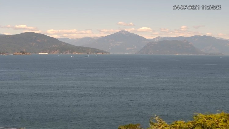
As I reached Cates Bay and Finisterre Island, I wondered if I would be visible on the Howe-sound.ca webcam? I sent a message to my in-laws’ family chat group to see if they could see me. I thought the boys would get a kick out of it. Unfortunately, they were off on their adventure and didn’t see my message until later. I did, however, try to get a screenshot myself to see if I was visible. It is not great, but it worked out better than my last attempt. This time I think I am actually in the photo.
It is nearly impossible to see, but (I think) I am the teal-ish coloured vessel barely visible in the left of the image below. I am the blur to the left of the small white boat in the left of the picture.
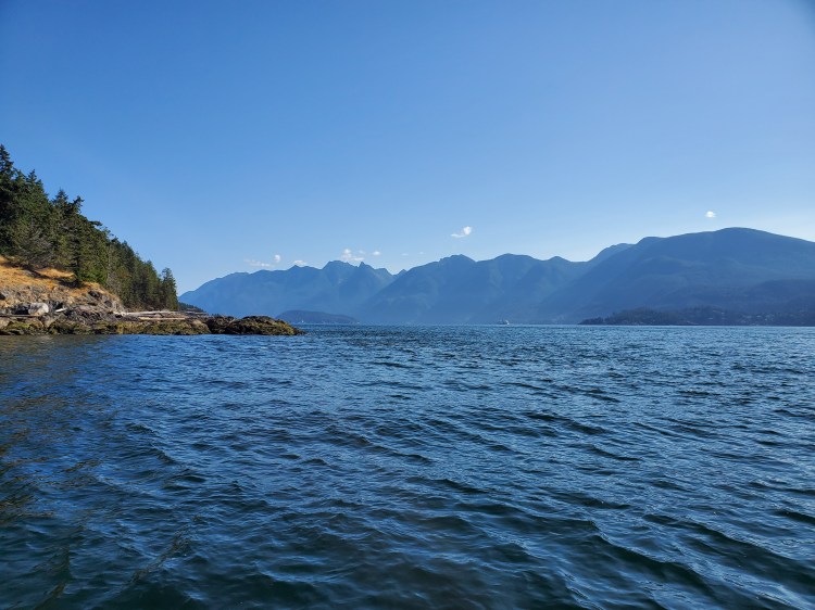
I rounded Finisterre Island and passed Montevista and Enchanta Bay before rounding Hood Point, as seen in the photo below. The Hope Point peninsula of Gambier Island is on the right. At this point, I was in search of a lunch spot.
I landed at Underhill/Sole Beach in Smugglers Cove for a rest and lunch. My first hot meal of the trip. On the menu was Nomad Nutrition Ukrainian Borscht which I had picked up at MEC along with some trail mix, an apple, and dried mangoes. Below is the view from Underhill Beach looking into the sound. Gambier Island is on the left of the image, and both Halkett Point and Bay are visible.

After lunch, I decided to make one more modification to my board setup. I brought my rear bungee cords forward. I wasn’t planning on doing it, but this way if I needed to I could set back over the top of my kit to do a step back/pivot turn if required. I had less room to manoeuvre but the weight on my board was more centred.
Below is the view west along the northern coast of Bowen Island. You can see a sailboat and the ferry in the distance and the southwest peninsula of Gambier Island.

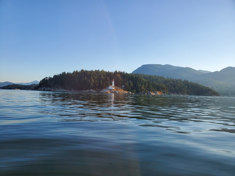
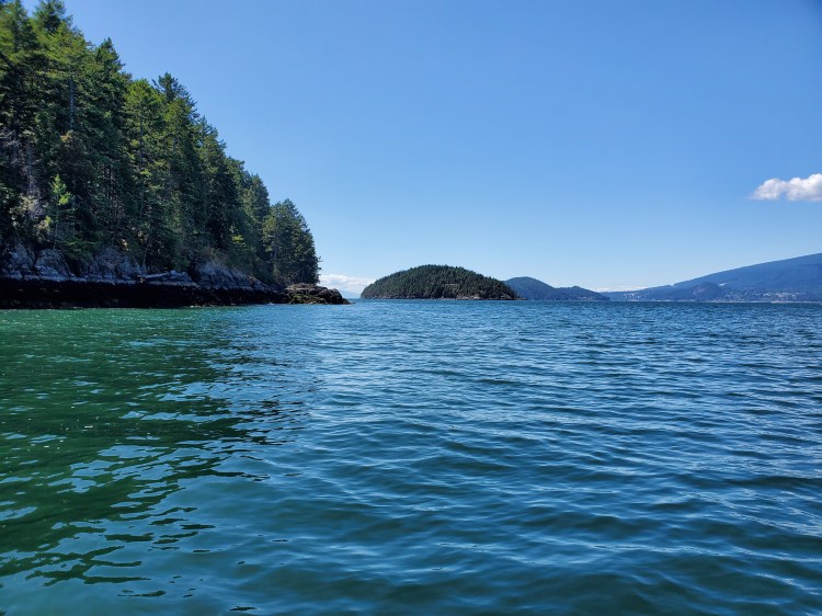
And a bit further along, I could see Hutt Island in the distance. In the photo below, there is Bowen Island, then the tip of Hutt Island, then behind that is Keats Island, and then the mainland of the Sunshine Coast.
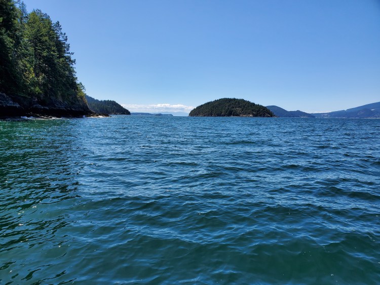
And here is Hutt Island in full view. Little Flower Islet, my camping destination, is just in front of Hutt Island.
But as I approached the northeastern corner of Bowen Island and could see down Collingwood Channel, there was a strong southerly wind. It was going to be a tough last leg.
After a mix of head-down paddling, Connor Baxter’s “Choke Stroke“, and some kneeling paddling to reduce my windage, I was within striking distance of Little Flower Islet. The BC Marine Trails site suggests landing on the southeastern side of the tombolo connecting Hutt to Little Flower Islet, particularly at low tide. It is a shell-based landing with the path to Little Flower Islet lined with mussels.
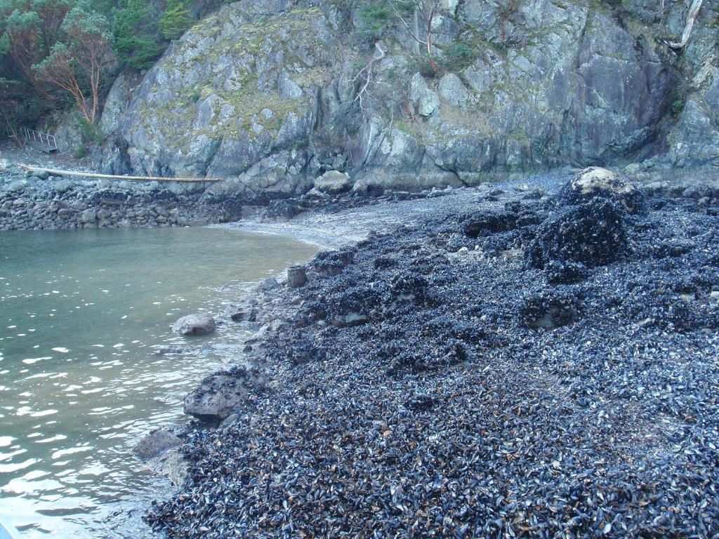
Source: https://www.bcmarinetrails.org/map_site/10048/

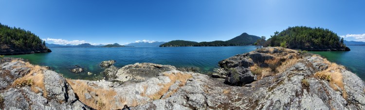
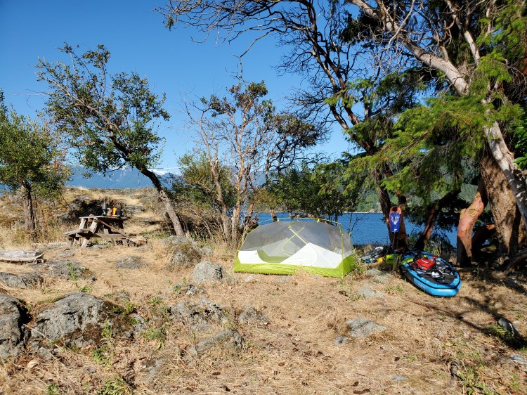
Once on land, I surveyed the landscape, trying to determine where to stow my board overnight for the tidal shift. I made my way to the northern tip of the island to take the panoramic photos below. Hutt Island is visible on both the right and left of the image (there is a slight overlap), with Gambier Island in the centre and the Sunshine Coast in the distant background.
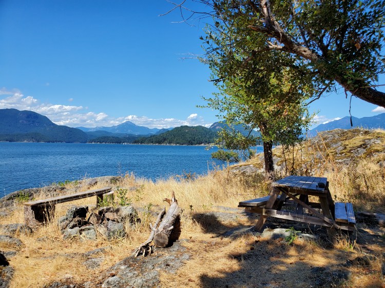
I was happy to find the picnic table shown in an image from the BC Marine Trails website still there. Though, it seemed to have been repositioned. I was happy to have it in a more shady area. There were also two benches and a rock campfire pit.
I unloaded my gear and had a short rest. Then I decided to do a pass around Hutt Island before setting up camp and making dinner.
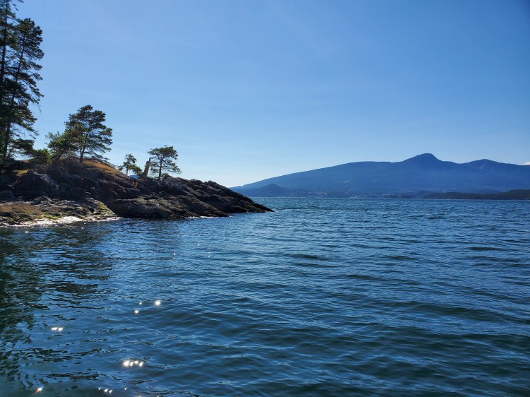
The image below is the northern tip of Hutt Island.
And this image shows the clouds forming over the top of the Coastal Mountains. Mount Wrottesley is the peak on the right with Panther Peak, Tetrahedron Peak, and Mount Varley to the left of Gambier.

After rounding Hutt Island, I decided to stow my board up at the campsite. No issue with tide here, and my board was light without any gear loaded. With my camp set up, it was time for dinner.
It was another dehydrated meal for dinner. This time Sweet and Sour Pork by Mountain House. Funnily, when I had first purchased these meals, one of our kittens did some investigating and had punctured the bag. I had quickly removed the bags from the kitten’s reach and then put them aside where they couldn’t access them. And when it came time to pack, remembering this, I tried to find which food pack had punctured. But I couldn’t find any holes. I found them quickly as soon as I pour the boiling water into this packet. The top left corner in the image below is where I sprung a leak. Luckily, there was no harm done with the hot water.
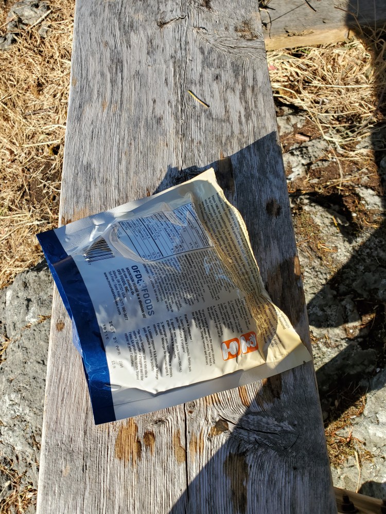
Fortunately, I had duct tape, which I used to seal off my SUP pump for the voyage over. I patched up my pork package, and it was perfect for my primal pig-out.

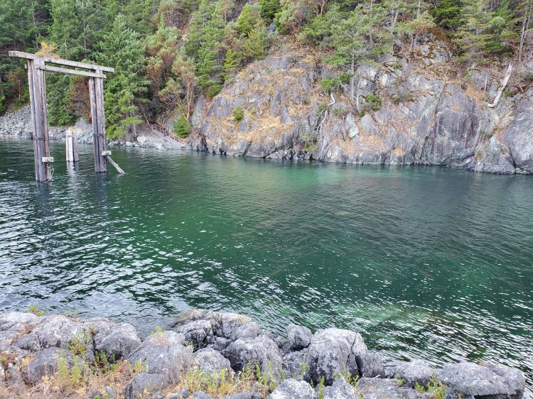
I missed taking a photo of the tombolo when it was low tide. But I was glad to have brought my board up before high tide. Earlier in the day, I had landed on the seashell shoreline that is the light colouration beneath the water.
Before calling it a night, I did need to answer nature’s call. I vaguely remembered reading something on the BC Marine Trails site about leaving no trace. And from memory, that included no digging, which posed a dilemma. Fortunately, we had some doggy-doo bags leftover from our children’s diaper days that I had packed to use as garbage bags for this trip. Wrapping up your child’s waste in an airtight bag until you could find a proper disposal place was a trick my sister-in-law had shown us. I put a similar rendition of it into play here. But that was something that I failed to take into consideration before embarking on this trip. A small island with no outhouse and a leave-no-trace directive puts you in a bit of a pickle.
Below is the Code of Conduct from the BC Marine Trails site. I wasn’t far off in my recollection of the rules (see the third bullet point).
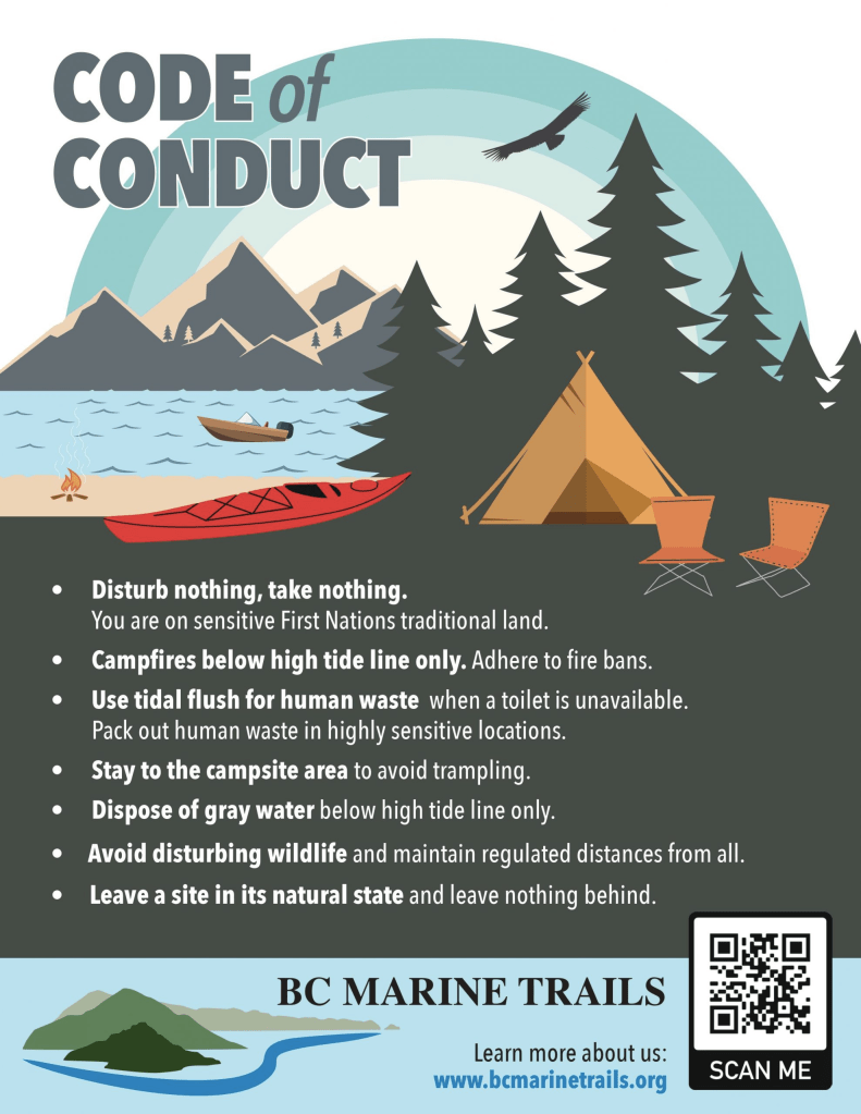
Source: https://www.bcmarinetrails.org/code-of-conduct/
For day two and the rest of the adventure stay tuned (or check here). . . .
Addendum
It seems that the pseudo-rules around camping on Nex̱wlélex̱m (Bowen Island) have changed. There is now an official BC Parks campsite at Apodaca Park, though it did not come without controversy.

5 thoughts on “Shh…Hutt Island: Bowen Island Circumnavigation”