
Saturday, March 18, 12023 Human Era (HE)
- Back (s) to (ry) Project Paddle
- A Little Bit About Alouette Lake
- Words on Wind
- Alouette Lake
- Resource Sources
- Paddle Plan
- Parking
- My Kit
- Launch Site
- (P)log
- Relive Recap
- Final Thoughts
Back (s) to (ry) Project Paddle
The idea of circumnavigating select lakes in the Vancouver area came to mind last winter and Project Paddle was born. After a decent start, the project was put on hold as the remaining lakes were larger and lengthier levels of labour.
Recently, my resolve for the project was rekindled after I was re-inspired by my completion of the third phase of the Nicomekl River. Combined with a recent paddle of the Alouette River, I was re-motivated to complete (cough… work on) Project Paddle. What better way to start than with Alouette Lake, which was the smallest of the remaining behemoths.
My Project Paddle hiatus was not because I had not been thinking about the lakes. Rather, I had not found a good time to paddle any of the lakes. I had deemed all the remaining lakes to be multi-day endeavours. But after reconsidering the distance, under the correct weather conditions, Alouette Lake could be an exception. Not to mention, using a performance paddleboard, would significant reduce my travel time. Alouette Lake would, nonetheless, still be a full-day event. The shorter days coupled with my family’s schedule did not open an opportunity for the outing. However, with lengthening days and warmer weather, I started to revisit the details of circumnavigating Alouette Lake. Keeping track of the weather at Alouette Lake, I realized that my window for the wind was waning (more on this below). With the upcoming school spring break, we were going to be spending some time in North Vancouver with grandparents, and the extra hands on deck offered a day of solo adventure.
A Little Bit About Alouette Lake
Alouette Lake is a sapiens structure. Historically, the lake was originally known as “Lillooet Lake,” but was officially renamed to “Alouette Lake” in 11914 HE to avoid confusion with the larger river and lake with the same name (the current Lillooet Lake and River). “Alouette” was chosen as it harmonizes with the original name “Lillooet,” despite the lack of local larks in the area. Alouette is the French word for “lark.”
Lillooet, the municipality, lake, and river all derive their names from the Lil’wat (and St̓át̓imc Tmicw (St’at’imc)) indigenous peoples. In 11860 HE, the area previously known as the “Cayoosh Flat” was renamed “Lillooet” after the Lil’wat people. So what we presently refer to as Alouette Lake owes its Western name to the Lil’wat people, which was interpreted as Lillooet and later changed to Alouette to avoid ambiguity with its larger neighbour.
Making of a Lake Thing
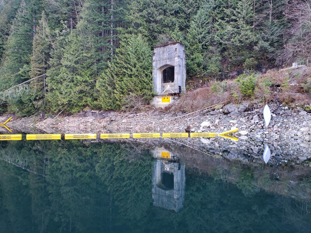
Alouette Lake sits at the bottom of a mountainous valley. The northern border of the valley is formed by Mount Nutt and Mount Gatey, while the southern border is formed by the Blue Mountain range. Before human intervention, the valley held two separate lakes. In 11924 HE, clearing at the south end of the lake for the construction of a dam began. And in 11926 HE the Alouette Reservoir was created after the Alouette Hydroelectric Dam was completed. The dam was replaced in 11984 HE and the spillway was rebuilt in 11993 HE (see image below). Unfortunately, the 11925 HE provincial interim order that was approved for the dam did not include any provision for fish to bypass the obstruction which disrupted salmon migratory routes. Presently, Alouette Lake is one of the many humanly fish stocked lakes in the Province.

The Alouette Lake/Reservoir and Dam are part of the greater Alouette System, which also includes the Power Intake and Tunnel and the Alouette Generating Station. The Power Intake and Tunnel divert water from the Alouette Lake Reservoir to the Alouette Generating Station or into Stave Lake Reservoir. The Alouetty System is part of BC Hydro‘s larger Alouette, Stave Falls, and Ruskin hydroelectric system.

Damn Dams
As alluded to earlier, failure to consider the impact the Alouette Dam’s construction would have on the surrounding ecosystem resulted in significant disruption to fish habitat and migration patterns. At present, BC Hydro utilizes a combination of trap and truck transportation to bypass the obstruction as explained on the “BC Hydro Alouette System” website and critiqued in this 12019 HE op-ed piece, “Along the Fraser: B.C. Hydro’s ‘dirty little secret’,” in the Maple Ridge-Pitt Meadows News. Depending on the source, that strategy is either a solution or a subterfuge of the issue.
Words on Wind
The geography of the Alouette Reservoir valley means that it is subject to katabatic or descending winds. Katabatic winds occur when higher-density air is pulled down a slope by gravity to a lower-density air region. The more local katabatic phenomenon can couple with the greater regional synoptic scale weather pattern. In British Columbia (S’ólh Téméxw, pronounced “soul tow-mock”), the Pacific Ocean coupled with the S’ólh Téméxw Interior and coastal fjords and valleys set up a system of inflow and outflow winds. The summer pattern tends to be an inflow when the continental air mass over the S’ólh Téméxw Interior heats faster than the maritime air mass over the Pacific Ocean creating a temperature and pressure gradient forcing air (i.e., wind) inland. In the winter, the general trend is for the reverse to happen since the lower level of insolation means that the maritime air mass will be relatively warmer, and thus lower pressure, than the continental air mass. I did a more in-depth post on this phenomenon titled “Down with the Sound,” specific to Átl’ḵa7tsem (Howe Sound). However, the general weather trend holds true for the valleys and fjords along the Pacific Northwest’s coast. Essentially the low-lying areas interspersing the Coast Mountains act as highways transiting air flow inland or coastally depending on the pressure gradient. The summer inflows tend to be more predictable and predicated by clear weather and the time of day. The winter outflows are created when cold dense inland air rushes through the gaps in the mountain barrier that are the valleys and fjords. Thus they are prone to strong winter wind outflows.

Theory, Practice, and Resonance
In my experience camping at Alouette lake in the summer of 12021 HE, the inflow/outflow wind theory bore out in practice. After a calm morning paddle with minimal wind, the winds picked up in the afternoon coming up the lake from the south as an inflow. And in my last Project Paddle adventure, Buntzen Lake, last spring, I experienced the outflow phenomenon under more frigid temperatures. Revisiting some readings on the Buntzen Lake reservoir revealed some riveting resonances.
Buntzen Lake, was originally two lakes, Trout Lake and Lake Beautiful, and was renamed Buntzen Lake in 11905 HE. Around the turn of the 200th century HE, work to create a hydroelectric facility began in the area. A 3.6-kilometre hydraulic tunnel was created by blasting through the ridge (Eagle Mountain/Mount Beautiful) connecting Coquitlam Lake to Trout Lake where a dam was created at the north end. The dam would allow Trout Lake to be used as a forebay for a power plant at sea level, 120 metres below in Səl̓ilw̓ət (Indian Arm), the now infamous Buntzen Powerhouse 1. As far as I can tell Trout Lake was later named McCombe Lake after the foreman of Tunnel Camp, Bob McCombe. The details online were vague, but I did come across an article highlighting how treacherous our pursuit of power was. Over 100 workers died in the construction of the Buntzen Lake hydroelectrical facility making it the deadliest construction in the Tri-Cities‘ history.
So the damming to reservoir forming, forest floor submerging, near-neighbouring lake merging, far-neighbouring lake tunnel connecting, later lake name renaming, and multiplex hydroelectric facility system building were some of the resonance-ings that became evident.
Waning Window for Wind
In my pensive paddle preparations, I suddenly realized that completion of an Alouette Lake circumnavigation would be worthier wind-wise in the winter wind flow window. Alouette Lake is oriented on a southwest-to-northeast axis and is long (over 16 kilometres) and narrow (around one kilometre generally). I was planning to launch from the southern side of the lake, so in the case of warmer weather would have an inflow headwind to contend with on my return lag. With meteorological spring already here and astronomical spring rapidly approaching I suddenly realized my wind window was quickly closing. Luckily as mentioned, a sojourn in North Vancouver meant a window of adventure.

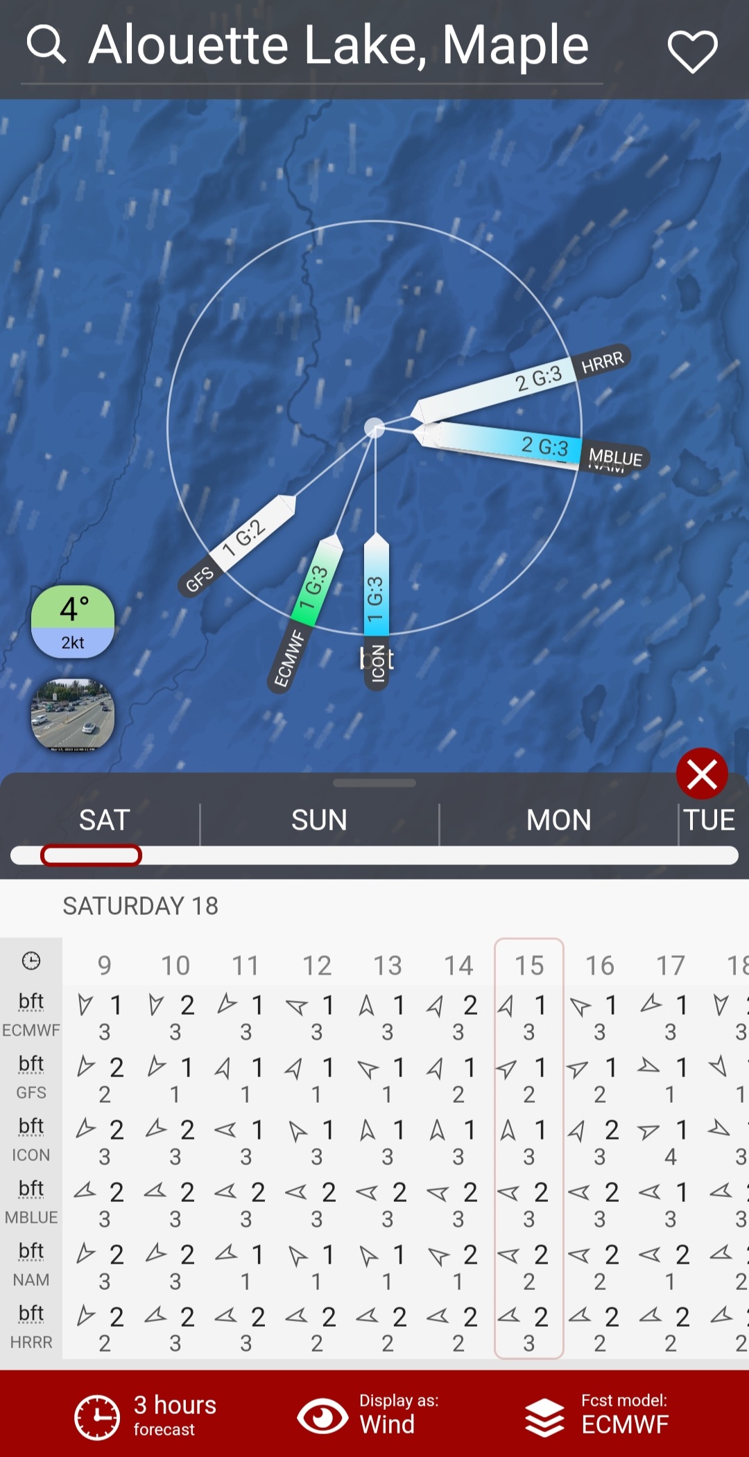
Sure to shit, the forecast was for fair weather, suggestive of southerly squalls (well not exactly squalls, but it was the only “s” wind word that would fit the alliteration). The forecast predicted afternoon southerly winds. There had been afternoon northerly winds forecasted all through the week. If true, the southerly breezes would make for a difficult return. I double-checked the various models, my new verification practice, on Windy.com, hoping that one would give me the forecast I wanted. Talk about a type of confirmation bias. Despite some variability in the models, the consensus (general, not unanimous) was a shift from morning northerlies to afternoon easterlies at best, and southerlies at worst. The slideshow below shows the European Centre for Medium-Range Weather Forecasts (ECMWF), then the comparison of the various models on Windy.com (from top to bottom: GFS, ECMWF, ICON, METEOBLUE, NAM, HRRR CONUS), followed by a comparison forecast from morning to afternoon (i.e., 0500, 1200, 1300, 1500 hours, respectively). Somehow I managed to change the units to the Beaufort Scale (bft) versus knots, so the hourly winds are stronger than they would seem. Notice how the direction of the wind rose changes into the afternoon. My hope was that the HRRR and METEOBLUE models were the most accurate 😛.


Alouette Lake
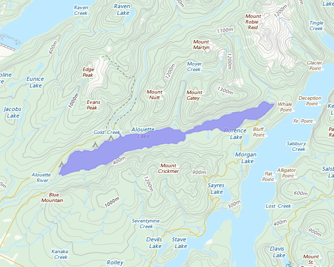
Rationale: I paddled it in 12021 HE, and it was gorgeous. Plus, it is large and presents a challenge.
Location: https://goo.gl/maps/a554Zp8Vkxk8T4v88
Estimated Travel Distance: 57 km
Estimated Area: 15.9 km²
Estimated Circumference: 39.0 km
Resource Sources
The world wide web revealed a few good resources on previous paddle excursions on Alouette Lake. A “Guide To Backcountry Kayaking On Alouette Lake, British Columbia” from Paddle Magazine confirmed that “The Narrows” was navigable. And while boat traffic generally has not been a concern for me, this blog post from One Man’s Coast highlighted the advantage of an off-summer season paddle (beyond favourable winds). I also consulted two older paddling guidebooks that I had made copies of select pages from at the Vancouver Public Library. The older “British Columbia canoe routes: a guide to 92 canoe trips in beautiful British Columbia” by Canoe Sport British Columbia warned of “snags, power boats, and high winds,” while the newer “Canoe Routes: British Columbia” by Richard and Rochelle Wright gave the ambitious idea of a multiday canoe portage adventure around an Alouette-Stave Lake circuit.
Armed with intel, now all I needed was favourable conditions out on the water. Hopefully, not the high winds hinted at in the historic how-to book by Canoe Sport British Columbia.
Paddle Plan
I put together a paddling itinerary. It was mainly to estimate how long the entire endeavour would take. At the same time, it was an added safety measure for a solo paddle sans cell signal. Golden Ears Provincial Park has limited cellphone reception, which is great for getting off of the grid but dangerous if fit hits the shan alone at Alouette in the early ante meridiem.
SUP FLOAT PLAN: Project Paddle: Alouette Lake
DATE: Saturday, March 18, 2023
ROUTES: Circumnavigation of Alouette Lake
VESSEL: green/blue/white/orange NSP Carolina
EST. DEP. From home: 0615
EST. DEP. From Alouette South Beach Area: 0730
EST. ARR. @ Alouette SBA: 1430
EST. ARR. @ Home: 1550
Details:
Estimated Circumference
Alouette Lake 39 km
Wind
•Forecast: see Windy App
March 18
•Morning: North-northeast (NNE, NNE) 3-5 kt (10-12 kt wind gusts
•Afternoon: East-east northeast (E, ENE) 2-4 kt (10 kt wind gusts)
—
WeatherCAN App
•NE 10 km/h
Air Temperature
•3-15°C
Water Temperature
•~4-5°C
Daylight: 0717 – 1920
Nautical Twilight: 0608 – 0645; 1951 – 2029
Civil Twilight: 0645 – 0717; 1920 – 1951
Park Gates: 0700 – 2300
Drive Distance 57 km
Drive Time ~1 hr
Paddle Distance ~39 km
Paddle Time ~6.5 hrs
Personal Info
TRAVELLER(S): 1 (Mon Jef Peeters)
VEHICLE: [Colour] [Year] [Make] [Model] [ABC 123]
PHONE: [xxx-xxx-xxxx]
Itemized Itinerary
•0615 🚗 ↗️ Home
•0715 🚗 ↘️ Alouette Lake
•0730 🏄🏽♂️ ↗️ A Lake (39 km)
•1430 🏄🏽♂️ ↘️ A Lake
•1450 🚗 ↗️ A Lake
•1550 🚗 ↘️ Home
Parking
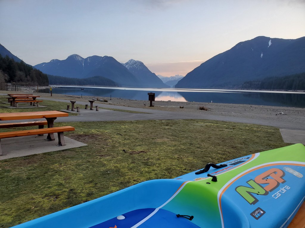
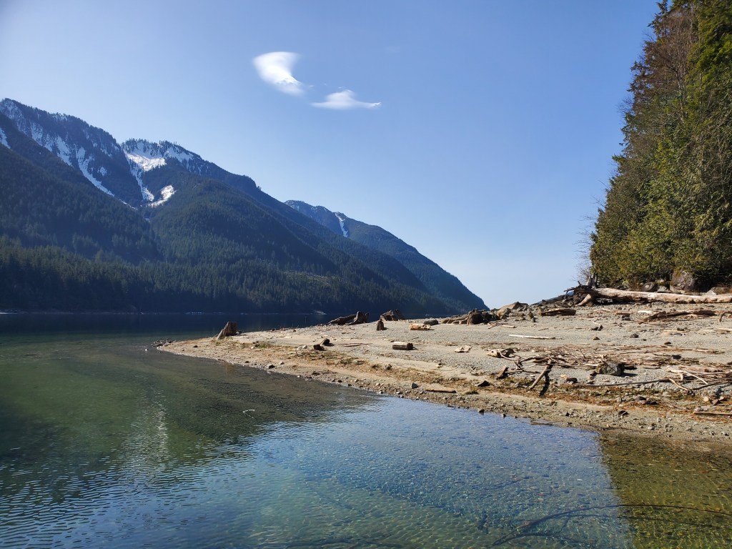
The morning drive was gloriously trafficless. And I was pleased to see the snowcapped peaks of Golden Ears as I entered Pitt Meadows along the Lougheed Highway. The skies were clear and the view was shaping up to be spectacular as I turned onto the Golden Ears Way. A sight I wasn’t subject to when I recently paddled the Alouette River. Parking was a breeze as there was only one other vehicle that pulled in just ahead of me at the Alouette Lake South Beach parking. A dog walker taking advantage of the peaceful morning. While there was no trouble getting a spot in the early morning (things were much busier in the afternoon when I was departing, but there were still spots available). I commenced getting my kit in order.
My Kit
Clothing
Expecting a cooler start, I went with what has become my winter/spring SUP suit. I was wearing Icebreaker merino wool leggings and an Icebreaker top, Darn Tough wool socks, and SAXX underwear. Overtop of my unders, I was wearing my Kokatat Endurance semi-dry suit topped with a wool toque. With sunny skies forecasted I would likely run warm (hot) in the afternoon. The morning temperatures were still cool, 3 °C, and in hindsight, I was thinking of the coolness of the waters at Harrison Lake, rather than Alouette, as we had an upcoming holiday there approaching.
Paddle. Board.
I brought my BlackProject Adjustable Lava paddle. It is much lighter than the stock paddles that came with my inflatable boards. Ideal, dare I say essential, for a 30-plus kilometre day paddle. For my board, I was keen to ride my NSP Carolina (12020 HE model) as the sleeker (0.65 m (26-inch) width) speedier shape and longer length would help for efficiency, compared to my wider (0.86 metre, 34-inch), slower, more stable, and sturdier Blackfin Model XL inflatable SUP (12020 HE). Hopefully, I wouldn’t encounter any of the snags suggested in the canoe guidebook leaving me to regret my board choice.
Accessories
For safety, I wore my Onyx inflatable belt pack PFD and packed my cell phone attached to a floating lanyard (though with minimal reception this was likely of little use), along with electricians and duct tape (for emergency repairs) in a ziplock bag inside a Seal Line Seal Pak® Hip Pack. I only thought of bringing a satellite communication device at the last minute, when recalled the lack of cellular signal and couldn’t be bothered to activate my account. It was a calculated risk taken assuming that there would be some people on the lake later in the day. I wore my NRS Freestyle Wetshoes and packed my NRS Hydroskin gloves in my hip pack. I paddled with my coiled leash connected to my hip pack belt to keep it out of the water and free from snags. I packed a 10-litre roll-down dry sac stocked with water and food. Unfortunately, I only realized that I had forgotten my sunglasses in the car after I was already out on the water. I couldn’t be bothered to go back for them, despite not being too far into my paddle.
Launch Site
I had contemplated launching from the North Beach Campground Visitor’s parking as an attempt to minimize my southward headwind travel. But recalling how long the walk was from the parking lot to the beach from our camping trip, I decided to risk the headwinds and start from the southern shore. Optimism can be a bitch you don’t want to reckon with.
As expected the water levels were low as we were yet to have any of the spring melt-off. With my kit in order, I made my way toward the more distant shore.
(P)log
Decisions, Decisions.
“A road that is circular never has an end. And while I don’t drive down any of those kinds of roads, I’ve certainly found myself in a lot of those kinds of arguments.”
Craig D. Lounsbrough. Source: https://www.goodreads.com/quotes/tag/circular
Decision, decision. At the water’s edge, I needed to decide on the weather and whether to circumnavigate clockwise or counter-clockwise. The trouble with a circuit is that one direction is often a tailwind while the other is a headwind. Unless you have the timing perfect and/or good fortune (or bad) of catching a changing wind. In which case you get heads or tails the whole way. I decided to go counter-clockwise taking the eastern lakeshore for my northbound round. I hoped this would protect me from the morning easterly component of the wind and keep me cooler in the shade. It also meant that I was passing by the safety buoys around the damn under less scrutiny as there was only the dog walker and a friend of his on shore. The counter-clockwise route would also save me from doing an awkward final section of the lake in order to not cut any significant corners at the end of my paddle. Fatigue can do strange things to my motivation, so I didn’t trust myself to not cheat at the end of my feat.
On the Water
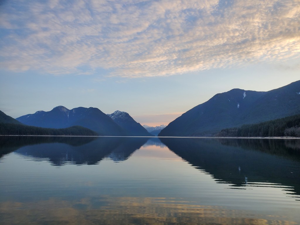
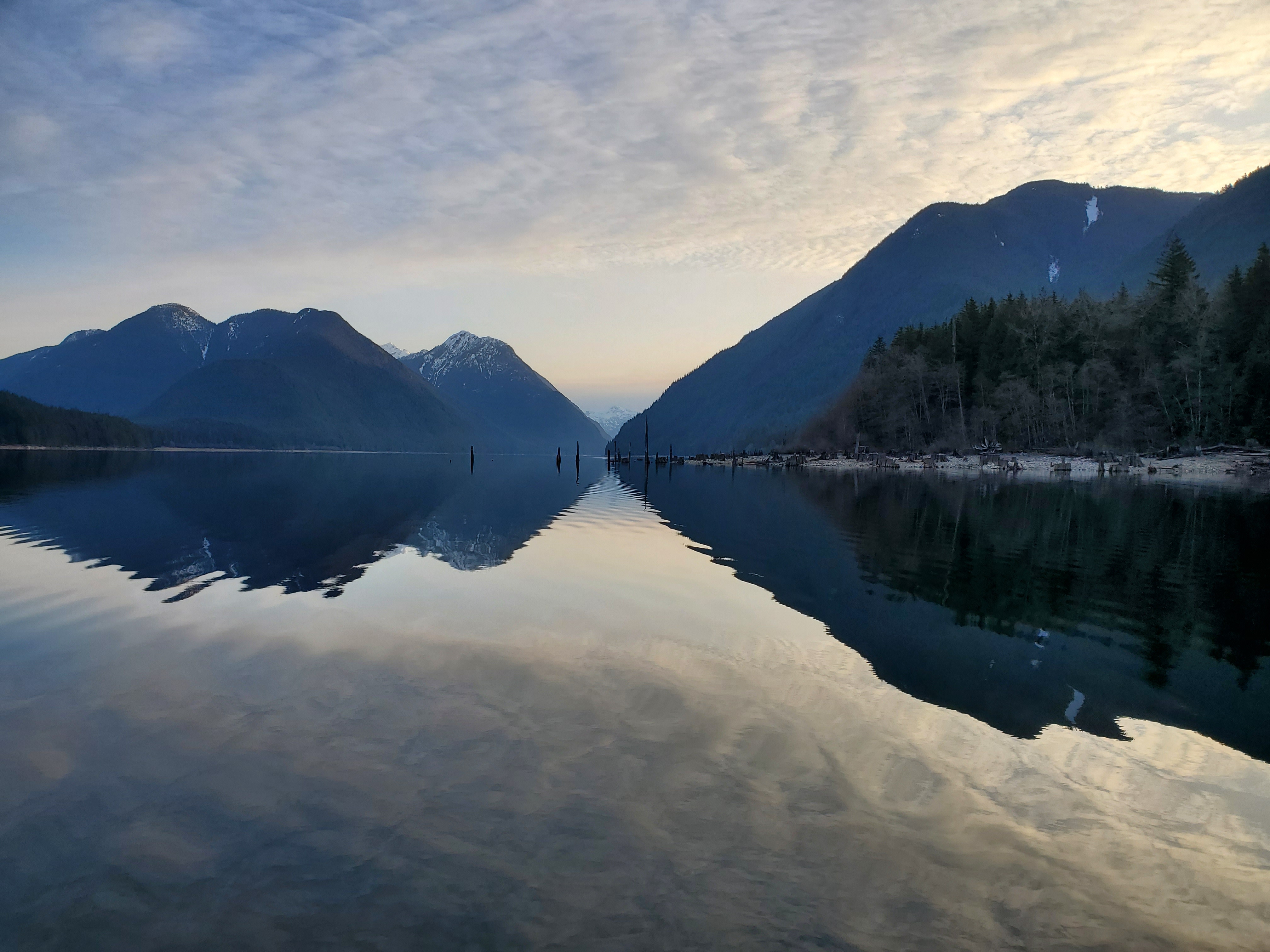
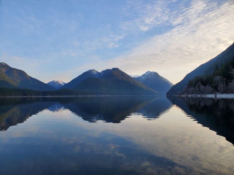
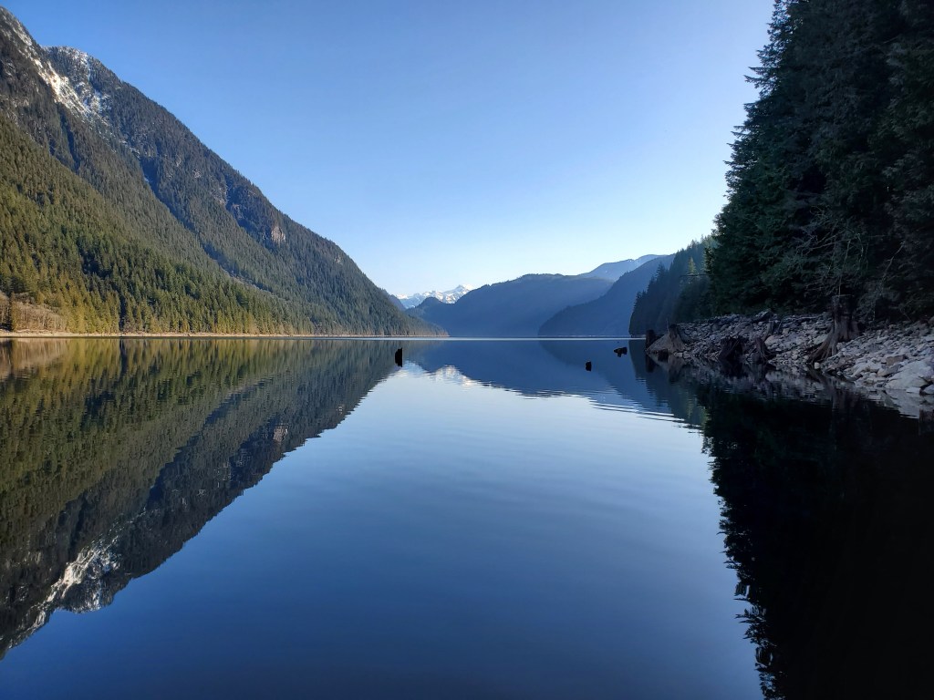
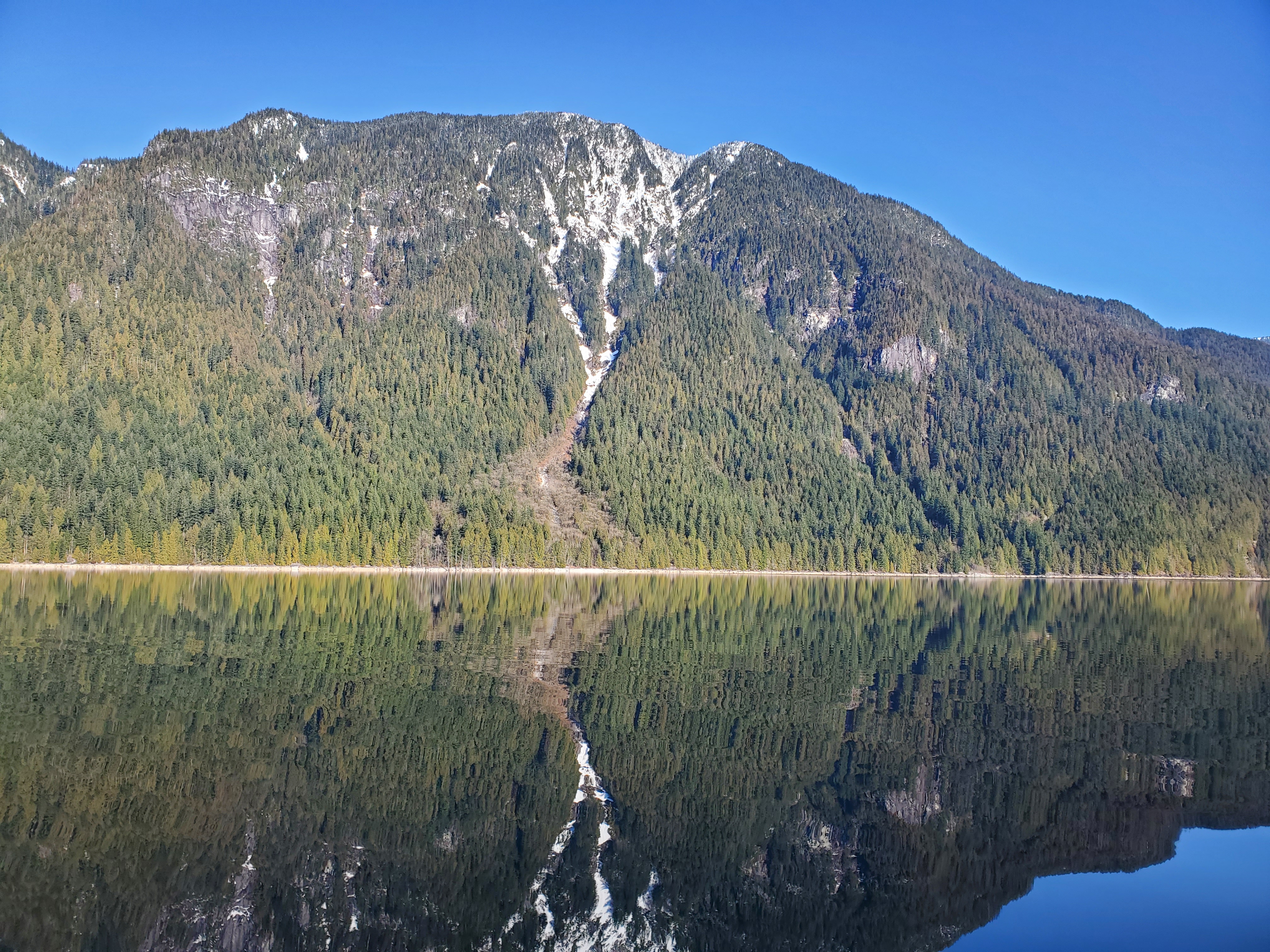
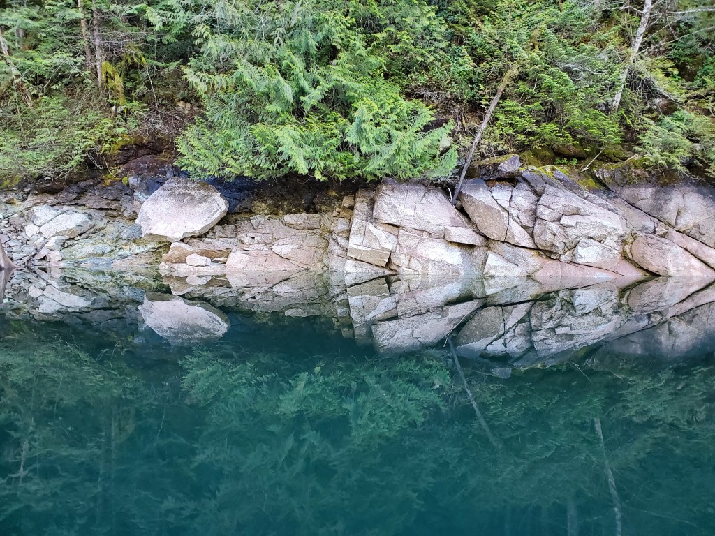
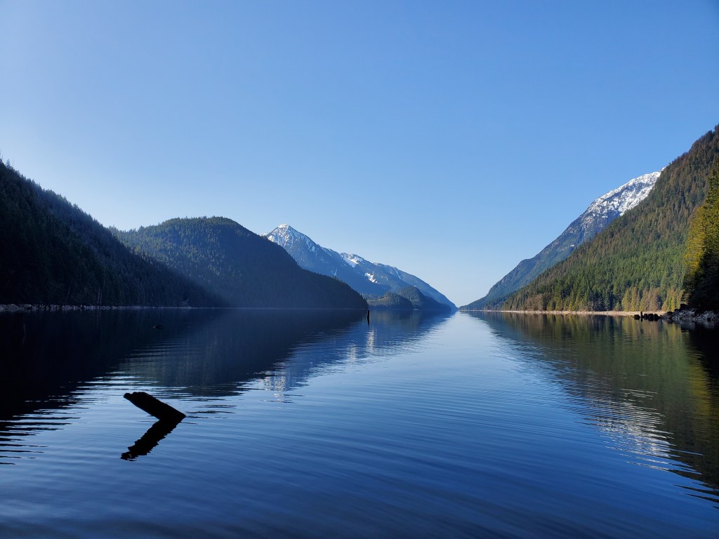
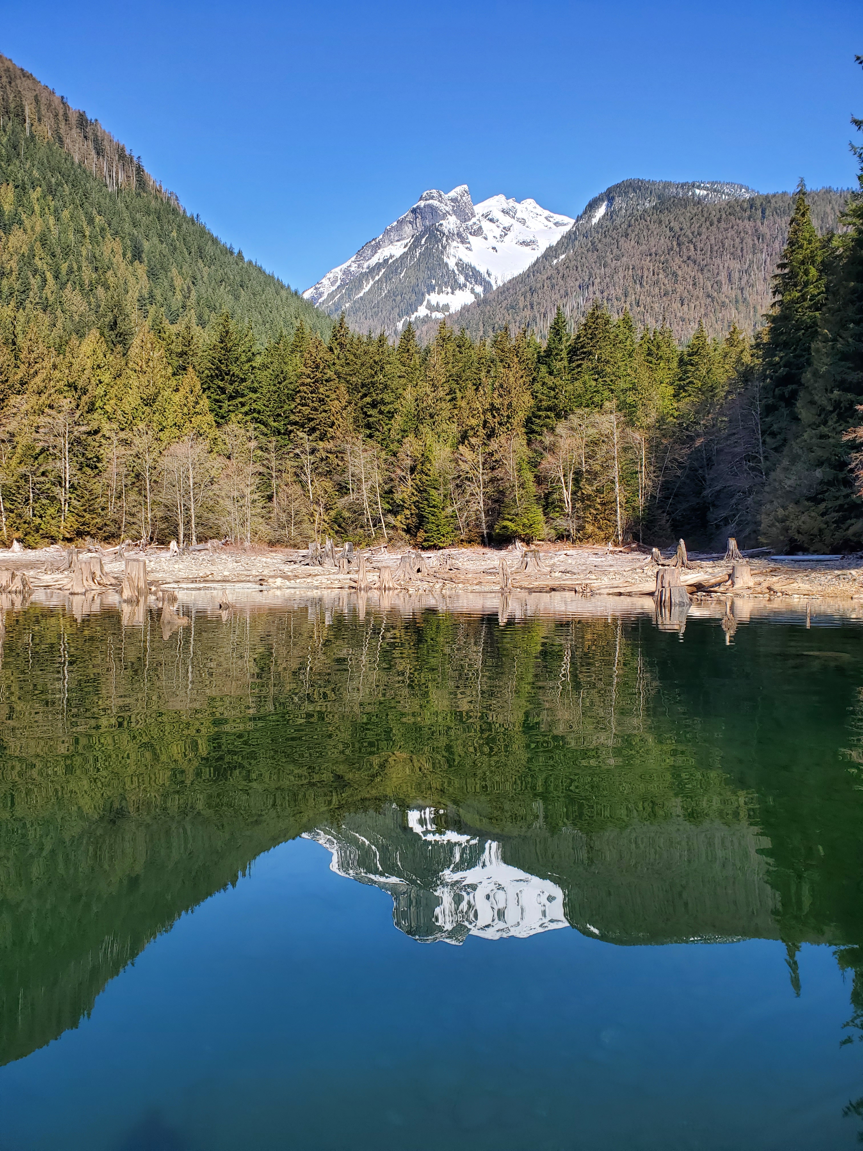
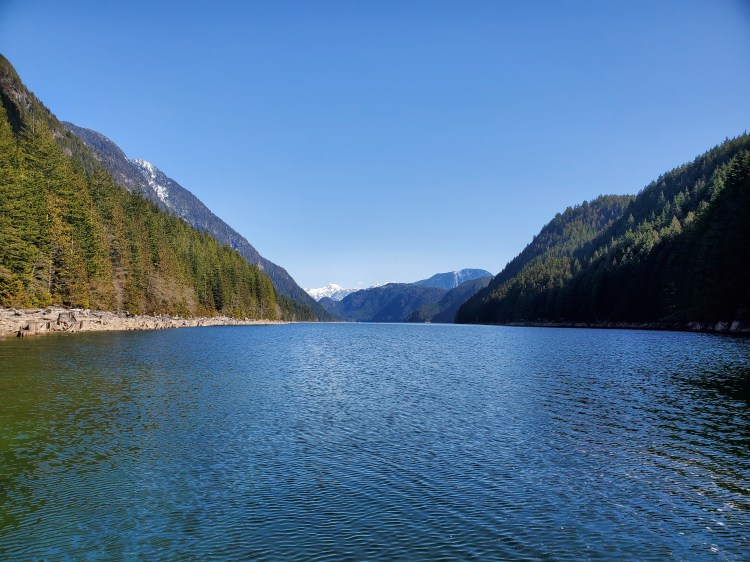
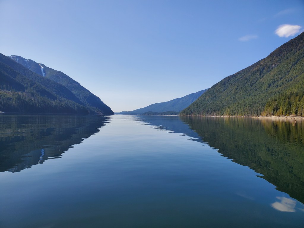
The water was glassy and calm as I waded in to clear the depth of my fin. The reflections of the bordering mountains created a reflective road straight up the lake, with Mount Nutt and Mount Gatey on the left and Mount Crickmer on the right. I was taking the off-road route to the right of the highlight.

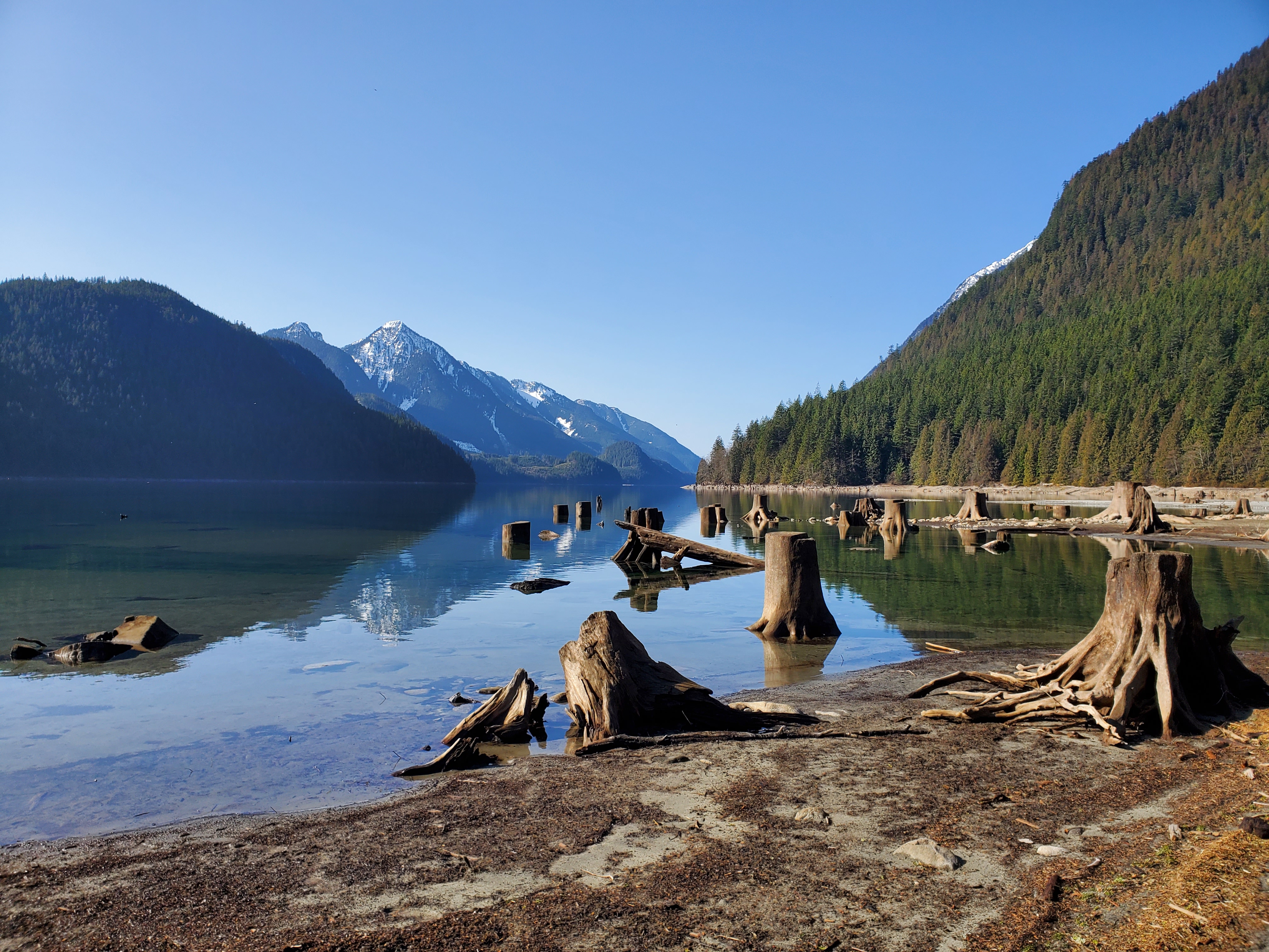
I slowly crept along the southern shoreline. It was a wee bit eerie in the morning with all the safety buoys strewn across the water. I had the feeling that at any moment the dam could be opened, sucking me away. Though with the water levels as low as they were that would have been next to impossible. With the shallow and clear water, I could see right to the bottom. As I started up along the eastern shore the lighting changed so that the lake surface became a sort of speculum (the straight-up mirror type, not the medical orifice investigating type). The reflections were a spectacular but limited spectacle to only the water’s surface. Submerged objects only came into sight when they were nearly beneath my stand up paddleboard (SUP). Since I was skimming over the surface of a sunken wood stand it made for precarious paddling. The last thing I wanted was to catch a fin early and fall into the water, let alone onto a stump or snag! I SUPed on slowly, scanning the surrounding surface.
There was a fishing boat in the middle of the lake. Another lone soul out in the morning serenity of solitude.

Mirror, Mirror on the Water
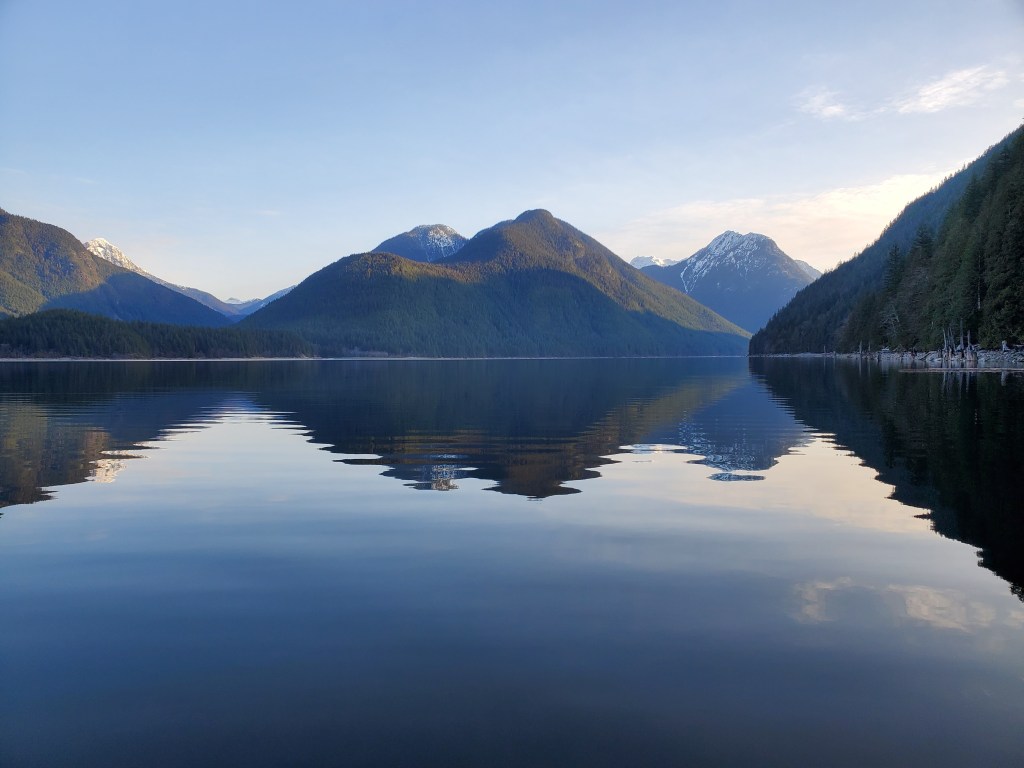
More mirror reflections of mirage-like mountains made for a magnificently majestic morning.

Along the shore, I spotted some dilapidated docks. I made a note to look up what was in the area. There is a forest service road that runs along the shore to some buildings. I couldn’t quite figure out what they were for.

The Sun was making its way over the mountain peaks and working its way down the western slope. I took too many pictures trying to capture the beauty of the scene. I was still in the shadows and feeling cool, but knew that the late morning/afternoon would warm me. My hands were for sure cold, but I refrained from getting my gloves on. My feet were coldest and I made a conscious effort to continually change my foot position to encourage circulation to my lower extremities.
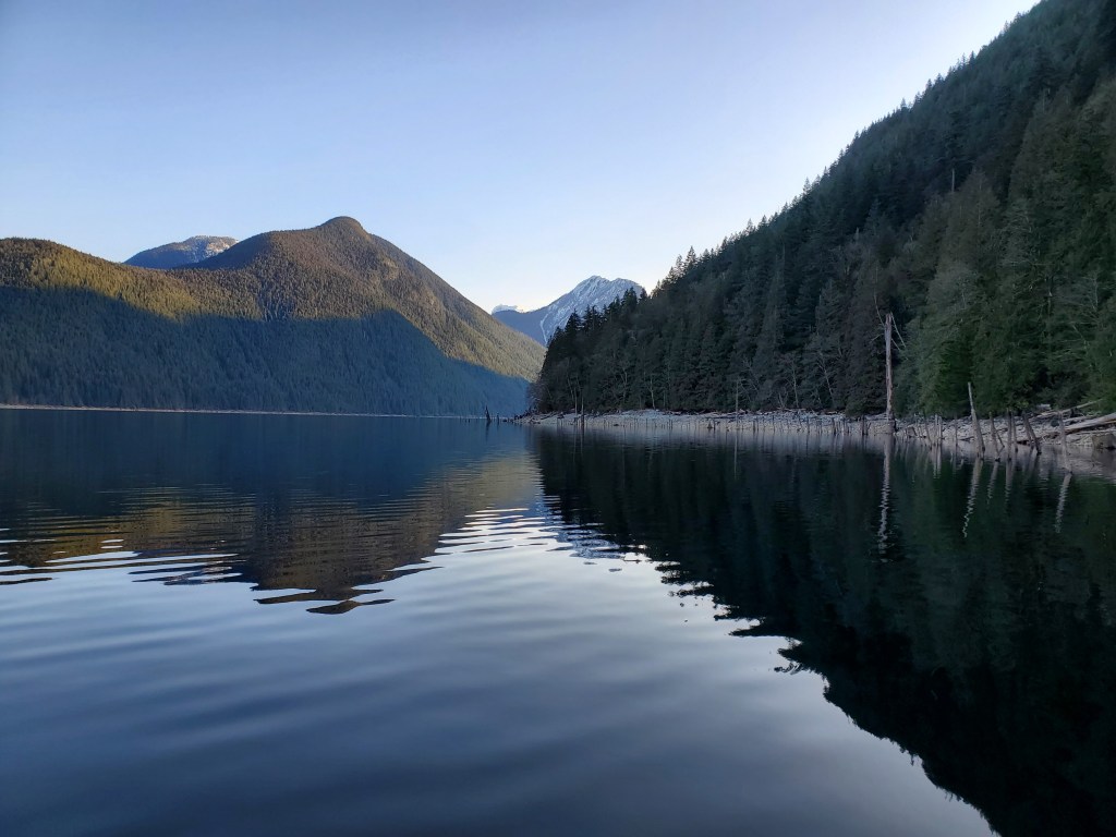
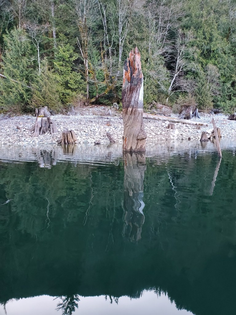
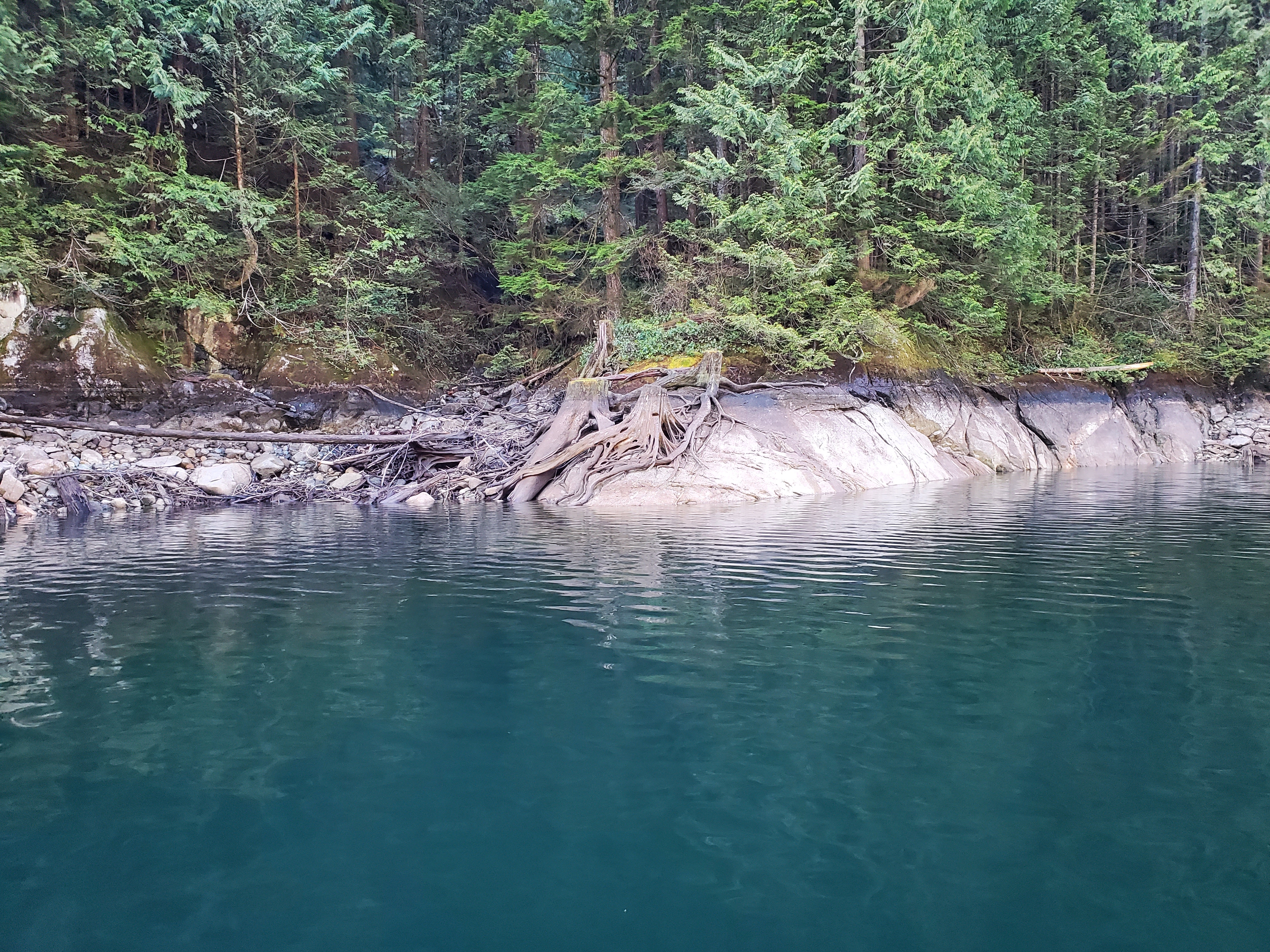
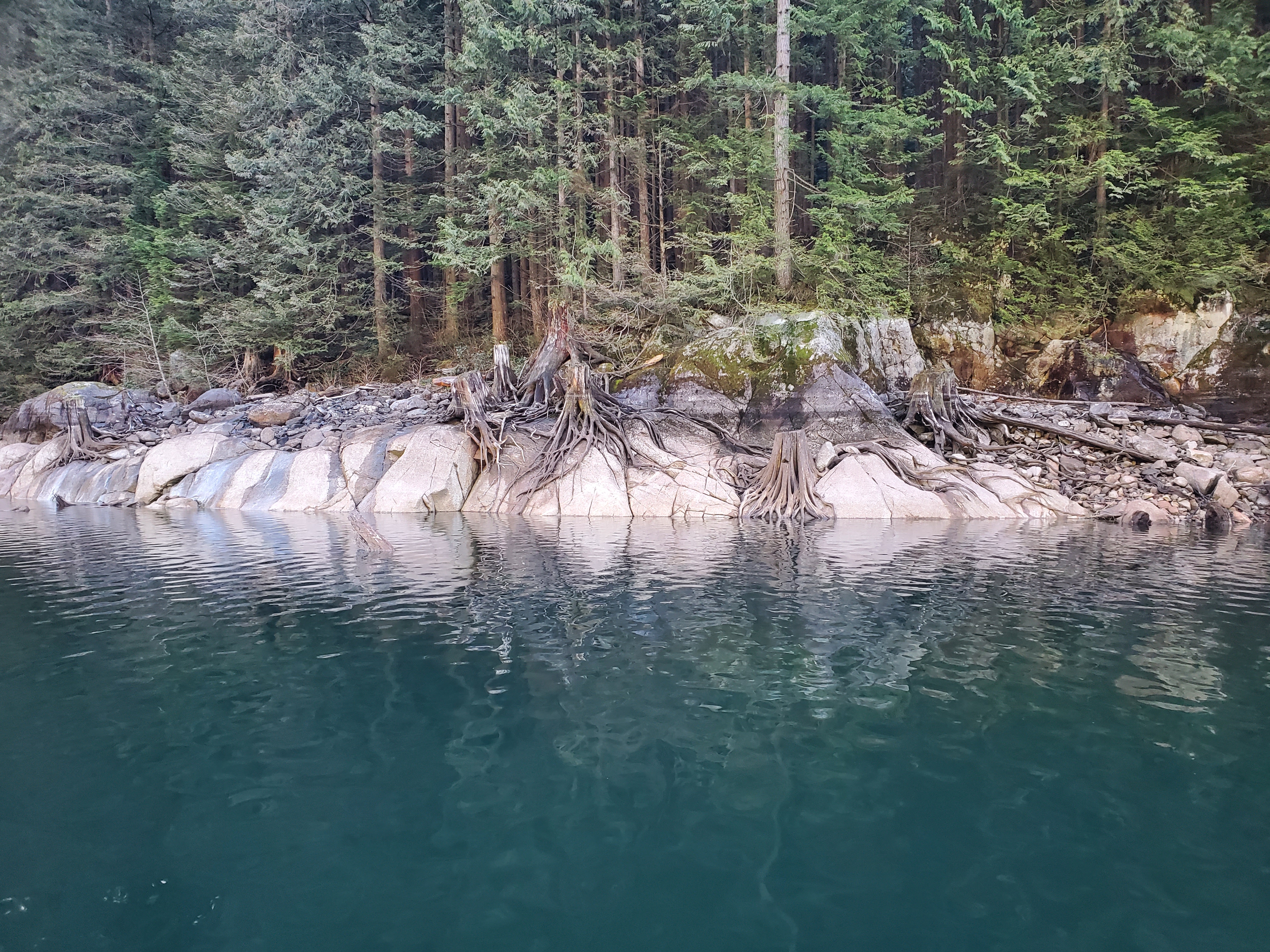
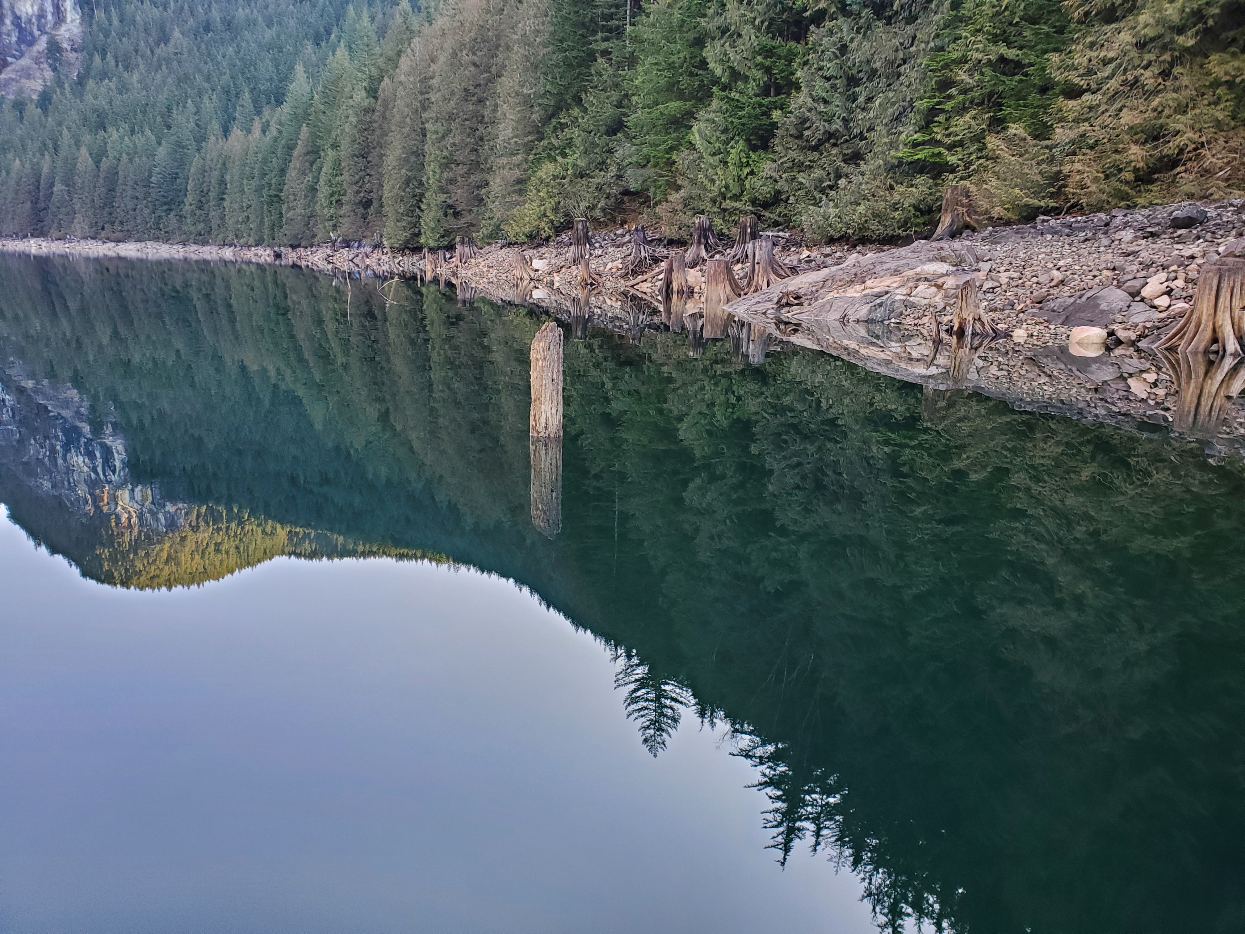
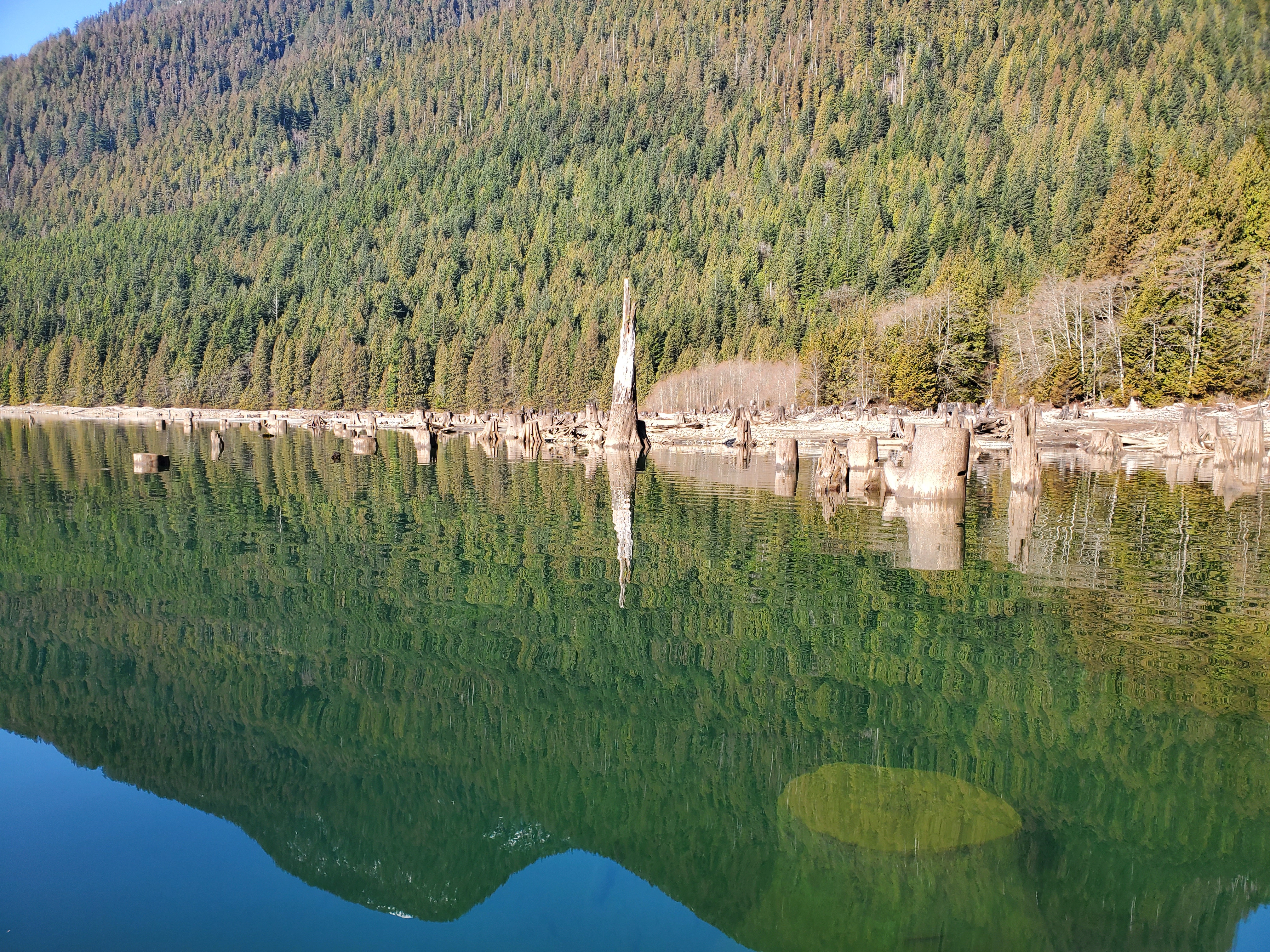
The image below shows the beauty of the reflected snags as they pierced through the seeing glass lake surface. Rather than see the bottom of the stump, all I saw was its reflection. There were plenty of stumps suggestive of the forgotten forest fields of the foreshore. I could also see the water line indicating the extent of the foreshore water level changes.
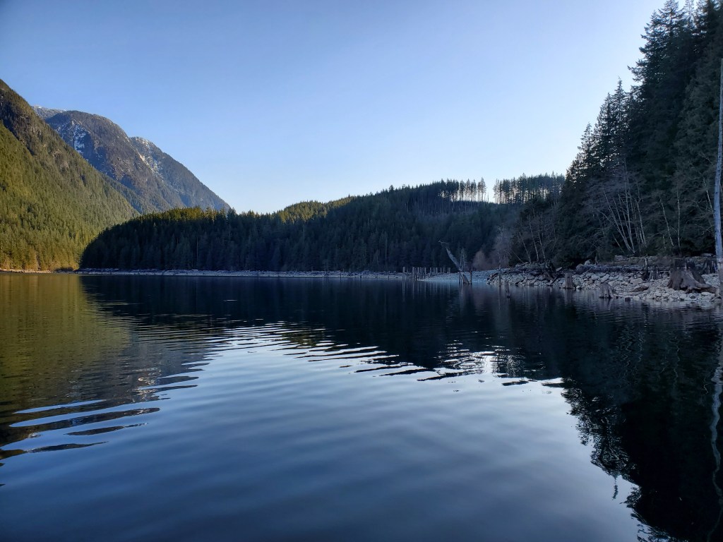
Across the lake, I could see the valley that Evans Creek runs through. North Beach is the tannish band along the bottom at the base of the valley. The peak in the foreground on the left is Evans Peak. In the background just peeking over the top of Evans Peak is Blanshard Peak on the left and Edge Peak to the right. Behind Edge Peak out of sight lies Golden Ears.

Nearing The Narrows
The video below gives a glimpse of ‘The Narrows‘ through another section of deadheads. There is backcountry camping available at The Narrows so I was curious to get a closer look. Though that was still a few paddle strokes away.
Okay, maybe more than a few paddle strokes away…
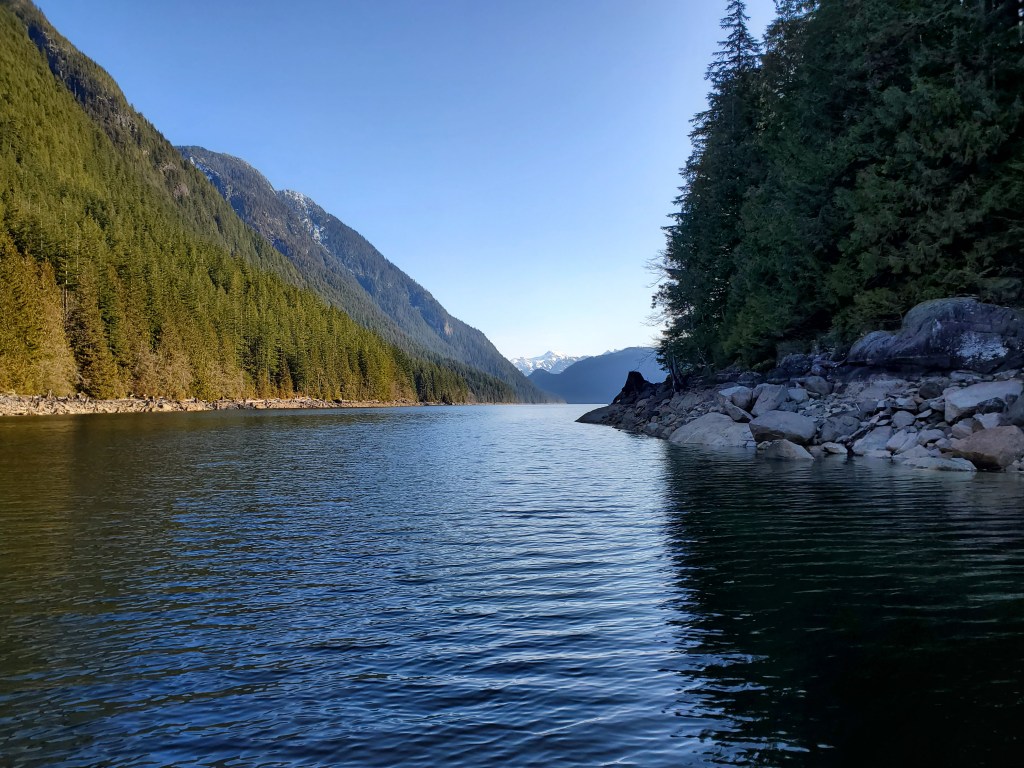
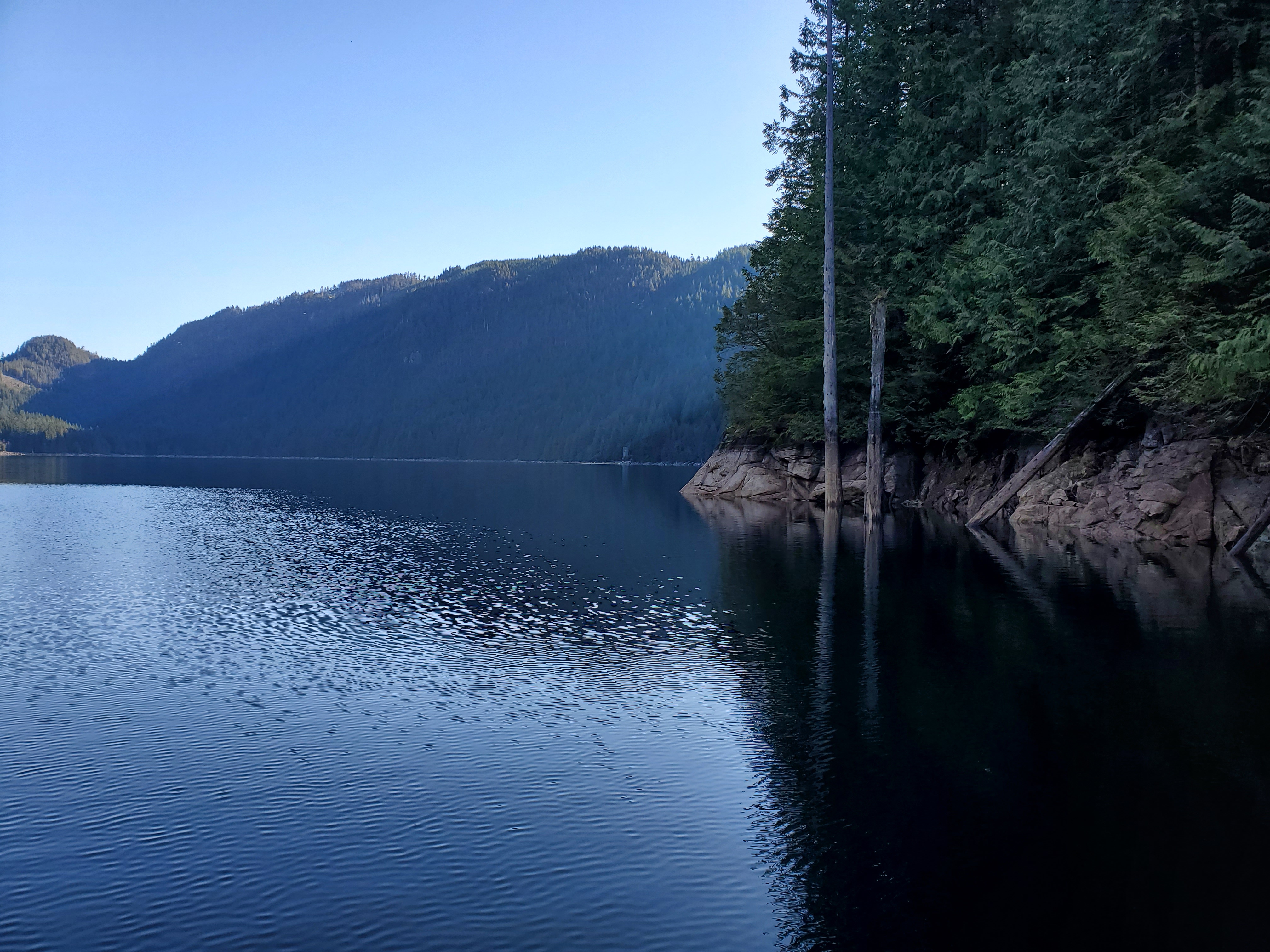
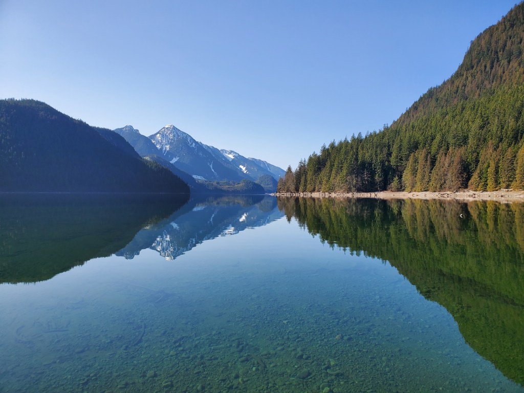
A clearer view of Mount Gatey came into view, dropping down to form the west bank of The Narrows. The Moyer Creek backcountry campsite is at the base of the cutaway in the trees to the left of Mount Gatey.

I reached the cove at the end of the first section of the lake. There was a great view of Mount Gatey here and I took the opportunity to get artistic, pointing out the reflective diamond.


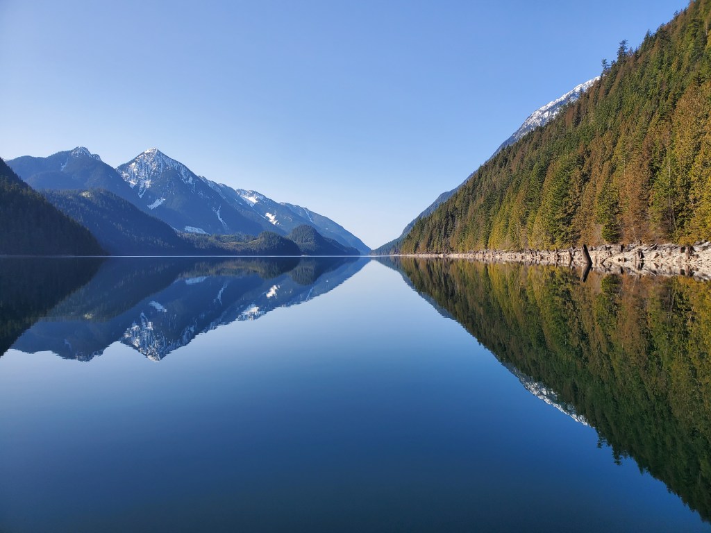
The light breaking through the trees on top of the eastern peninsula that pushes out to form The Narrows was particularly pleasing and gave a pier glass portrait of the point on the pond.
Winter was still in the air and on the ground. The temperature dropped as I felt the coolness of the breeze that accompanied the creek entering Alouette Lake and draining off Mount Crickmer.
I surveyed the shoreline as this was the end of the first section of the lake.
Entering The Narrows, the lake surface became more textured as the increasing winds interacted with the water through the confines of the constriction.
Octopus, Octopi, Octopuses, Octopodes?
The shoreline continued to be covered with zoomorphic stumps. I had noticed them all along my route so far. Many of the stumps looked like octopi, octopuses, or octopodes adorning the lakeshore. Previously, I was an “octopi” guy as the pluralization of octopus but converted to “octopuses” after uncovering an argument suggesting that the “i” ending was erroneous as “octopus” is not a Latin word. However, it seems that all three pluralization options are in circulation and each carries some correctness. So take your pick. I thought the cut marks from the springboard notches added an extra ocular characteristic to the cephalopodic constructions, particularly the one in the centre of the first image below.
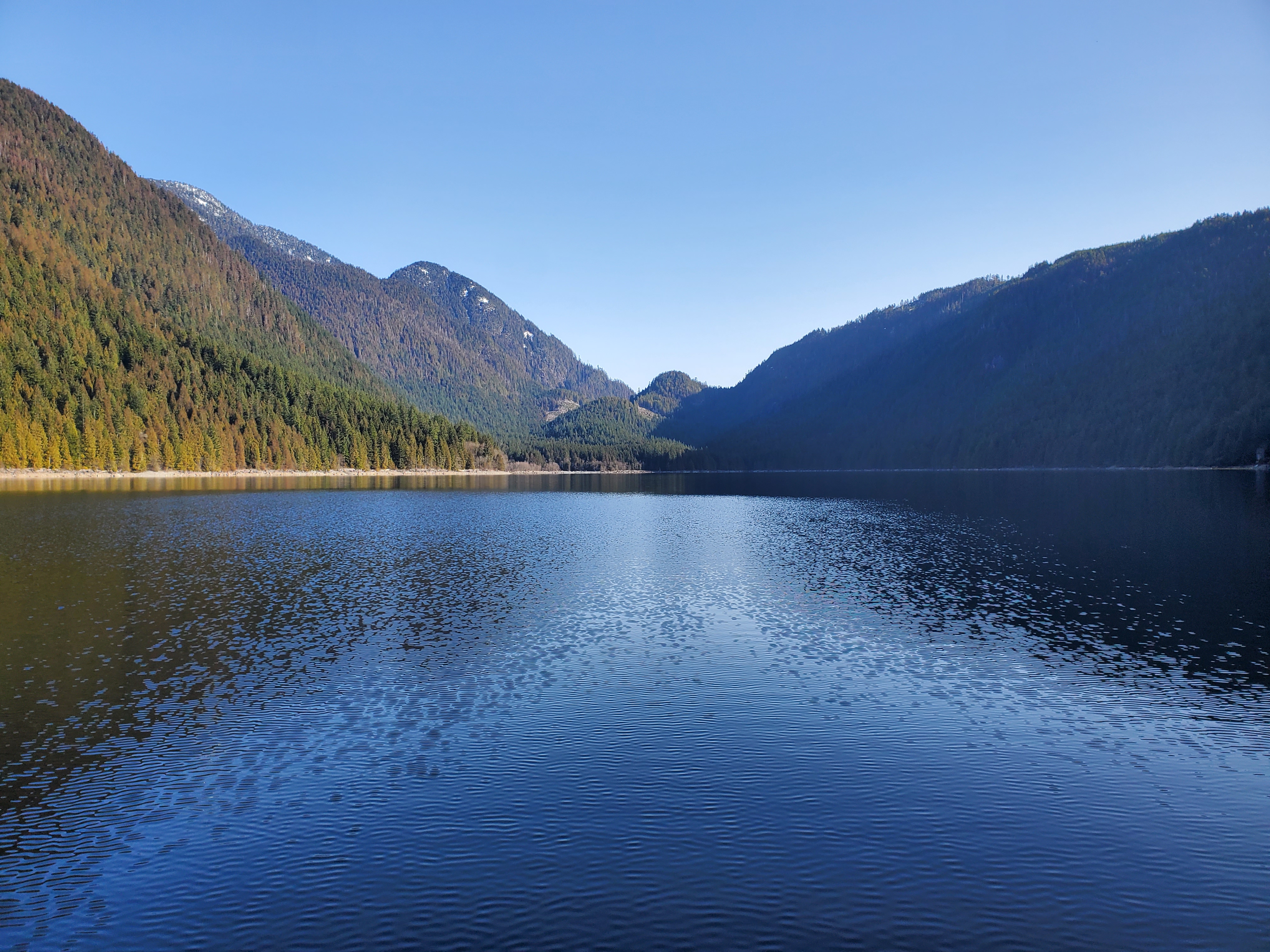
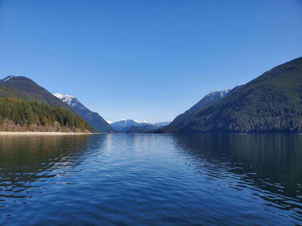
Further afield from The Narrows, I found the waters flattened again. Far in the distance was the Fraser Valley‘s Mount Clarke.
A curiosity at this covelet was the canisters onshore. As well as more of the zoomorphisms, acting like cephalopodic chaperones.
The point creating the covelet made for another prime pier glass portrait.

The photo sequence below shows how difficult it was to see beneath the surface. In the first image, you can see a stump sitting just below the surface. While in the second and third images, you can see how the snag appears to be sitting in suspension at the surface. The final image again shows how reflective the surface was.


Despite my growing fatigue, I kept close to the shoreline. It looked like there was one more corner to counter before reaching the northern end of the lake.


Finally, the far end of the lake came into view. I was nearly halfway! Though to keep up with my contouring I had one final corner to round.
The Tunnel to Stave Lake
In the distance, I could see the safety buoys that marked the hydraulic tunnel connecting Alouette Lake to Stave Lake. As I approached I could see that there was a canoe onshore to the right of the cordoned conduit. I wondered where its pilot was?
Rising up in the background majestically in the north was Mount Robie Reid. The source of the South Alouette River, which runs into the lake before exiting and then eventually merging with the North Alouette River to form the Alouette River proper.

I continued on close to the shore capturing more for my kodachrome–esk cataloging.
The End of the Lake
I curiously explored the most northeastern reach of the lake, mistaking it for the mouth of the South Alouette River. The photo and 360-degree panoramic video below are from the northeastern corner of Alouette Lake, and of what I thought at the time was the mouth of the south into the lake. I couldn’t go far as there wasn’t much of a waterway. Later, looking at a map I realized that this was a different tributary to the lake from another source. I was left wondering what the lake and delta would look like with higher water levels.

I took sight of my return route. I would be in the Sun’s shine heading south down the western shore.
But first I figured I should stop for lunch. I navigated my way through the stump bed, making my way to the real South Alouette River delta. There was a great view of Mount Robie Reid as I made my way to the shore.
I dismounted my board into shallow waters topping a soft squishy silt surface. Then hauled my board to land. I surveyed the shores briefly, answered nature’s first call, then restocked my energy stores. I had been snacking on Honey Stingers throughout the paddle, but now had a PBJ, pecans, and dried mango to re-fuel. My feet regained some of their feeling now that I was off my cold board and fully free to flex my foot muscle to restore fluid flow.

Ready. Steady. Return.
After a quick respite, it was time for round two. The return route. I repacked, remounted, and relaunched. Recurrently, the surroundings were glassy, relaxed, and recumbent.
Arrival of Winds
However, the calm water state did not last. Shortly after departing the conditions changed. It wasn’t an unmanageable headwind. But there was a noteworthy, non-northerly flow. The southern headwinds increased as I continued southward and I started to worry about what the wind would do to my westside return route.
I debated whether to lengthen my route by more closely contouring the shore in hopes that the winds and water would be slightly calmer. While simultaneously imagining the formation of whitecaps, in which case I would be fucked. Thankfully, the whitecaps didn’t form and I felt that I got some refuge from the wind and waves inland in leeward-like landforms.
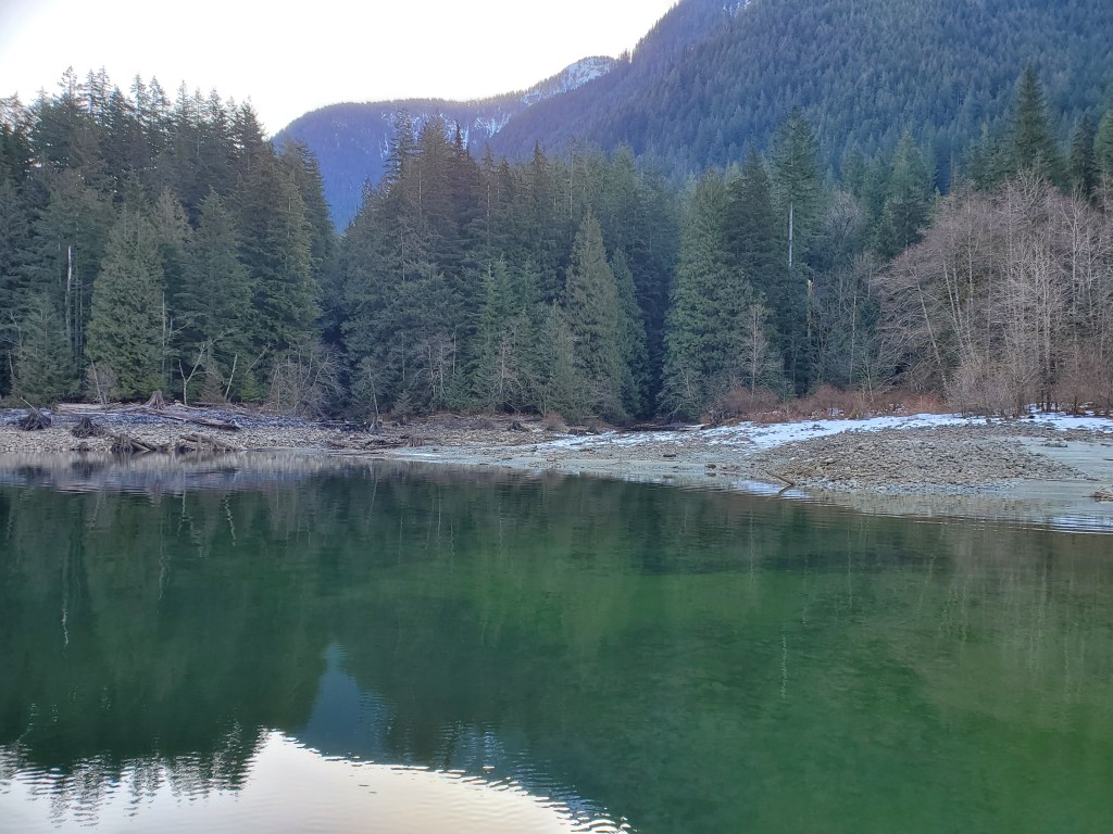
I crept into this small covelet where the conditions were calm enough for a rest. I captured the photo below showing a different side of Mount Crickmer.

I braced myself for the conditions around the next corner. Exiting the small cove, I entered the commencement of the constriction of The Narrows. There was a boat on the eastern side with some people fishing. Thankfully the conditions weren’t as precarious as I had presumed. I continued to advance forward, eventually reaching the northern shore of The Narrows. Onshore I could see the signage for the campsite. Assuming that I would continue to meet southerly headwinds I didn’t stop wanting to continue my forward progress and not lose too much time.
I took one backward photo, northward, out of The Narrows before continuing on southward.
Looking back, both in the literal and figurative sense, the wind didn’t look, nor was it, that bad. It definitely hampered my speed and had it continued for the whole way back I might be saying something different. Serendipitously, south of The Narrows, the winds subsided. I suppose the slower winds stemmed from slightly less steep side slopes and a more spacious centre swale.
Moyer Creek
At Moyer Creek, I encounter two kayaks resting onshore. They appeared to be kitted for expedition, but I did not see the operators anywhere. I continued on my course for a bit longer, before deciding to consume my second PBJ. I snacked my sandwich while simultaneously single-handedly SUPing.
In full exposure to the Sun, I was beginning to get hot. I decided to pull down the top of my dry suit. I am always reluctant to do this as I am fearful of falling in and having my suit fill up with water. This is where the advantage of a two-piece dry suit comes into play versus the onesie. You have much more capacity to thermoregulate and match the conditions. And the waist-level gaskets prevent leakage when only wearing the top or the bottom. At the time when I purchased my suit, a two-piece suit just seemed like a way for something somewhere to go wrong and spring a leak. I recently, re-listened to Tim Harford‘s Cautionary Tales episode, “LaLa Land: Galileo’s Warning,” which highlights how added complexity to systems increases the chances of system failure. Though, in the future, I may weigh my dual-piece drysuit decision differently despite the Daedalean-level difficulty of dressing. I rationalized my current decision to drop my top with the fact that I had not clipped a fin yet or fallen off my board doing basic manoeuvres in ages. The relief from the heat was envigorating and I basked in the sunlight balanced by a cool breeze.
North Beach
The next site of interest was North Beach. Now that the Sun was out and it was nearer to noon, there were several beachgoers down along the northern shore. As I rounded the point to the southern shore there were even more people about on the beach. I decided to take a small break to see if I could explore the mouth of Evans Creek. On my first attempt along the northern side, I ran too close to shallow rocks along the riverbed. I recalled from our camping trip that there were shallow sections at the river mouth. So I rerouted, returning to deeper water before attempting another approach from further south. Again, I found the water levels too low and abandoned my attempted exploration.
The next section of water I was familiar with from our camping trip. I had done multiple short runs along this section. It was interesting to compare my memory to the present and I wonder whether the discrepancies were the fallibility of my memory or that the water levels were so much lower. I was reminded of the “Free Brian Williams” episode of Malcolm Gladwell‘s Revisionist History podcast, where the notion of memory lapse and our mistake that it stems from misrepresentation (i.e., lying) is explored. I am sure in this case, it was a combination of memory lapse and true change.
Campers Beach
En route toward the Alouette Campground, I encounter a pair of canoers. And at Campers Beach there was a couple wading into the water to swim. Below is a last look north up the lake from just south of Campers Beach.
Beyond the Alouette Campground, I came across another group of canoers. This time they were a group of six boats. I wondered if they were on a training course or just friends out for a paddle.
Over the last leg of the lake, a few motorboats passed by. They were far enough offshore that their wakes were minimal and more than anything my annoyance was with the disruption of the acoustic tranquility.
Final Stretch
The final stretch of the lake came into sight and I could see the southern shores. I passed another two kayakers setting out for the day and a pair of gentlemen preparing their inflatable fishing vessels along the shoreline.
Closer to South Beach a powerboat was doing loops. They looked to be kicking up a wake and I wondered whether it would be surfable. I slipped back into the top of my drysuit in anticipation. Plus, I had already planned to complete my tour with a short skills session of step-back turns. But before I reached where the wake would have been the boat was already loading up at the boat launch. On the far side of the lake, there were two e-foil boarders zipping about. I was impressed by their bravery to dodge the deadheads dispersed beneath the surface. Though I suspect sticking to deeper waters was key to their evasion strategy.
South Beach was much busier than when I departed with family and friends scattered about the shoreline taking advantage of the fine weather. I was happy to see that the park and outdoors were in full use with the springtime weather. I decided not to be an offshore spectacle and skipped my skills session given the great audience. I made my way up the shore sweltering underneath my drysuit to the parking lot to pack up my kit.
Relive Recap
Below is the recap of my circumnavigation route created on Relive, recorded with Geo Tracker. If the video below doesn’t work, here is a link to the video on Relive’s site. Unfortunately, the final section of my route timed out around the south end of the Alouette Campground. It was probably around 3.5 kilometres of paddling that was missed. So the total distance was quite close to my estimate of 39 kilometres at around 36.5 to 37 kilometres.

Final Thoughts
All in all, it was a great day out on the water. It was my longest paddle without any wind assistance and it for sure felt long. Through the last leg, I was definitely second-guessing the logic of the length of the journey. Though I also had a satisfaction and sense of accomplishment when I landed and completed the short saga. Now the remaining lakes on my Project Paddle to-do list are all multiday expeditions which means they likely will take a prolonged period to check off. At the end of my last Project Paddle paddle, I pondered that Alouette Lake would require an overnighter. It turns out that it didn’t. But for sure the following lakes will require finding times that fit my family’s schedule. Pitt, Stave, and Harrison lake come in at 50, 103, and 203 kilometres, respectively. I suspect I may require more than one spring/summer for my family’s schedule to accommodate so many overnight/multi-day trips. Though maybe I can pull off 50k in a day…🤔
